
Category Archives: Air Pollution

Why is Trafford pushing ahead with the most harmful route option for the Carrington Relief Road?

By Lorraine Eagling

This summer, we have watched the effects of climate change across the UK, Europe and the rest of the world in horror.  Wildfires, flooding, extreme heat and crop failure is sadly a reality.  The scientists have said that things will only get worse if we don’t act now by cutting carbon emissions and protecting natures carbon capturing forests and mosses.

This is why we can-not understand why Trafford Council is so determined to destroy Carrington Moss (which Natural England confirms is a restorable irreplaceable habitat), constructing 4 major new roads on, across and around it, turning the Green Belt into Grey Belt and enabling yet more development in an area that is now saturated by ever increasing traffic, congestion and health threatening levels of pollution.  At a time when the Council should be following the advice of the scientists by restoring carbon capturing peat mosses (that also act as flood defences) and investing in public transport, they are capitulating to the wishes of the developers and spending £ millions of public monies on unsustainable road solutions.

The graphic below, taken from the latest Transport Assessment for the Carrington Relief Road (CRR), shows the predicted average daily traffic flows once the Carrington Relief Road, the Southern Link Road, the Eastern link road and the Sale West Link Road have been built. 
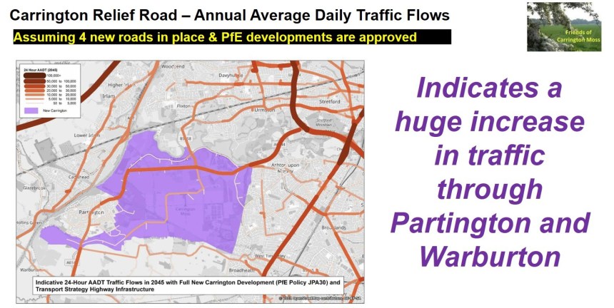
Trafford has stated that the CRR will ‘draw’ significant levels of traffic from the M60, the M56, the M6 and the A56.  Furthermore, in a recently issued Induced Traffic Technical Note, it states ‘The new trips associated with New Carrington development, plus normal growth of existing trips, will occupy almost all the available Masterplan transport capacity by around 2040’.  Effectively, this confirms that over £132million (minimum) will be spent on a new road that will be at capacity in less than 14 years.  This is NOT a good use of public money, especially given the significantly negative impact it will have on local communities as described below.

The Friends of Carrington Moss has been doing our own traffic counts for many years.  Here we compare the current average daily traffic flows taken from our data with the figures in the graphic above.

Currently the average daily traffic flow on the A6144 between Broadway and Lock Lane in Partington is 7,300 vehicles.  In the graphic, it shows that by 2045 the predicted average daily number of vehicles at the same location will be between 20,000 and 30,000.

Also, the average daily traffic flow on the A6144 at the Junction of Warburton Lane and Moss Lane is currently 5,000 vehicles.  In the graphic, it shows that by 2045 the predicted average daily number of vehicles at the same location will be between 20,000 and 30,000.

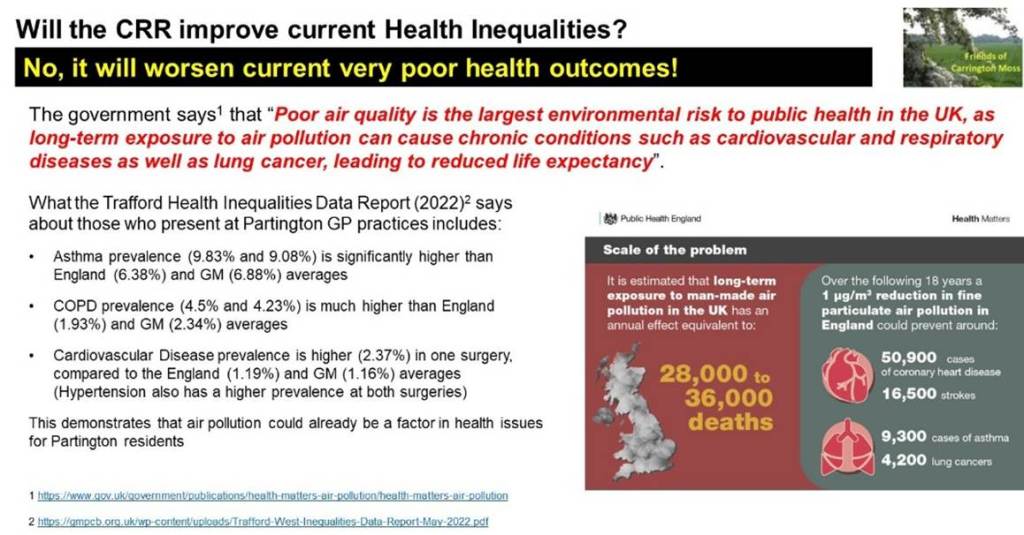
The implications for residents of Partington and Warburton are very concerning.  The significant increase in air, noise, light, vibration, dust and water pollution (to say nothing of carbon emissions) will not only have a detrimental effect on their wellbeing but will result in increased prevalence of long-term chronic health conditions, such as asthma, CPOD and cardiovascular disease.  These conditions are already a factor for Partington residents, with the Health Inequalities Report (2022) showing significantly higher incidence than the averages for England or Greater Manchester.

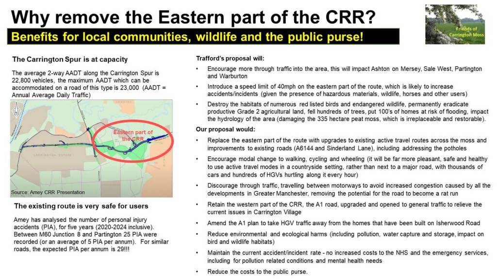
Currently, the average daily traffic flow on the Carrington Spur is 25,000 vehicles.  By 2045 it is predicted to be anything between 30,000 and 50,000.  That means that potentially there will be double the amount of traffic on a road that is already at capacity.  Referring to the Junction of the Carrington Spur and Banky Lane, the latest CRR Transport Assessment August 2026 (3.4.41) states ‘it can be concluded that the junction is operating near its absolute capacity with no spare capacity to accommodate additional traffic demands in the peak periods’.

Currently, the average daily traffic flow on Carrington Lane between the Carrington Spur and Flixton Road is 18,000.  By 2045 it is predicted to be between 25,000 and 35,000 taking the CRR and the A6144 figures into account.  Again, this is almost double the amount of traffic on the local road network which demonstrates that the CRR will reassign traffic onto local roads.

Currently, the average daily traffic flow on Carrington Lane heading towards Sale West is 21,000.  By 2045, however, the graphic shows a flow between 10,000 and 20,000.  This is unlikely when you consider this figure should include the traffic associated with the development of around 1,500 new homes in Sale West.  We will question the source of the figures for the current traffic flows to/from Sale West and Ashton on Mersey as the CRR Project Team appear to have considerably underestimated the volume of traffic.

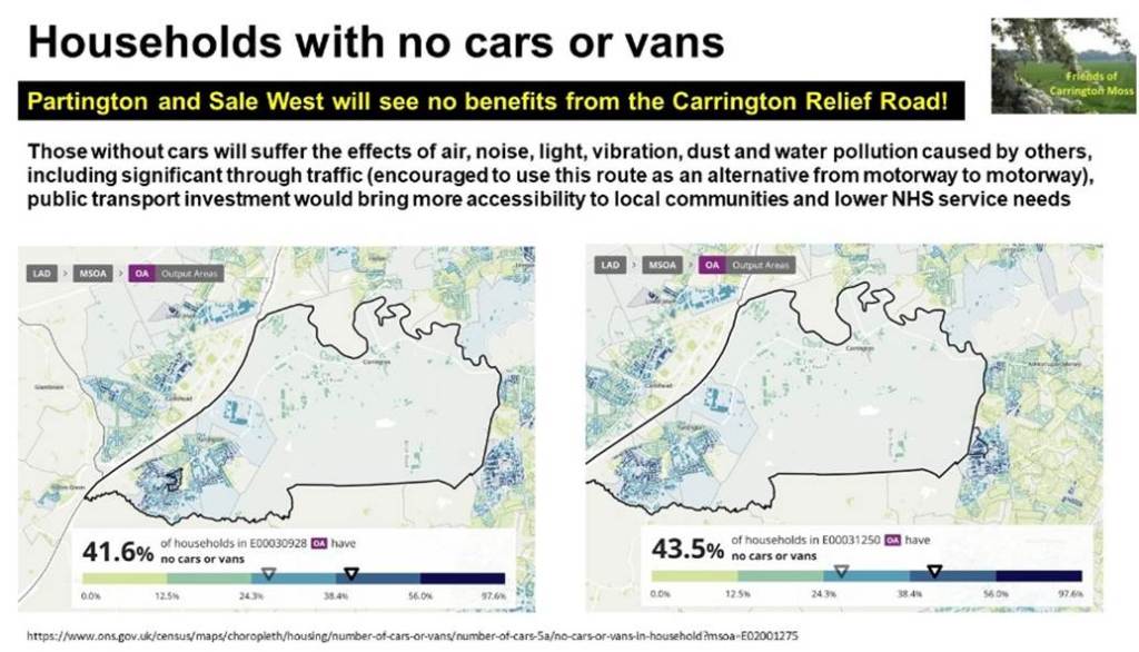
The community put forward an alternative solution back in 2021.  Our option would not result in induced or reassigned traffic because it does not involve building new road capacity.  That alternative solution enables much more of the allocated funding to be directed at public transport (very important, given that over 40% of households in parts of Partington and Sale West do not have access to a car, according to ONS data).  

The community alternative option, which was created following discussions between FOCM, Parish Councils and other community groups, has been repeatedly presented to Trafford, and, in summary, comprises the following:

  • open the existing A1 route to bypass Carrington Village for improved traffic flow and to reduce congestion during peak hours, ensuring a smoother journey for all commuters.
  • create a short link (running parallel with Isherwood Road between the A1 junction with Isherwood Road and Carrington Lane) to bypass the new homes on Isherwood Road
  • provide upgrades to the existing A6144 (resurfacing, removing potholes, improving signage)
  • improve the public rights of way and permitted routes on, across and around Carrington Moss (including resurfacing, low-level wildlife-friendly lighting and better signage), leading to much greater levels of modal shift, encouraging residents to walk, cycle or horse ride using pleasant, healthy and safe alternatives to the road network (peaceful routes with no harmful pollution).

In addition, our community alternative is considerably less environmentally and ecologically harmful than the route currently proposed by Trafford (which causes ‘County-scale’ decline to red listed birds, will remove 40 hectares of Grade 2 agricultural land from food production, is likely to result in flooding of existing and new homes and, as a consequence of changes in hydrology, could cause permanent harm to the 335-hectare peat moss).

Furthermore, we have looked at other initiatives, such as reopening the former railway line and constructing a bridge across the Manchester Ship Canal (something that is now being considered by Trafford elsewhere in the borough).

Sadly, Trafford has repeatedly ignored our alternative option and has chosen the most environmentally damaging option against the advice of Natural England.  We have recently discovered that the traffic numbers in the option appraisal which led to the decision about the route of the road were unreliable and that Trafford had dismissed our alternative option because they misunderstood TfGM’s standards for active travel routes.

Given the now very visible impact of climate change, Trafford should be focused on climate mitigation and nature’s recovery, minimising the destruction of, or harms to, the area’s vital natural capital assets!  That is why we have formally requested that Trafford Council reconsider the community alternative option in a fair and balanced way.
Trafford is making us sick – but do they care???

Local, regional and national policy highlights the importance of ensuring new development does not impact the health and wellbeing of both human and wildlife species.  Whilst this has been partially recognised in the planning application, we do not believe Trafford’s assessments acknowledge the serious impacts that will be incurred by local residents and conservation areas.  This is particularly the case given the flawed approach to calculating the anticipated traffic volumes (many of the expected journeys have been excluded from the numbers and comparisons have been made with districts that have access to wide-ranging public transport services, including railway stations).

The National Planning Policy Framework (NPPF) suggests at paragraph 96 that planning policies and decisions should aim to achieve healthy, inclusive and safe places which (c) “enable and support healthy lives, through both promoting good health and preventing ill-health, especially where this would address identified local health and well-being needs and reduce health inequalities between the most and least deprived communities”.

The Carrington Relief Road (CRR) certainly does not comply with this policy.  It will generate huge increases in traffic, not only along the road itself, but also along the east and west-bound A6144.  This will lead to similarly huge increases in air, noise, light, vibration, dust and water pollution (including from road run-off).  The risks and the impact have been substantially understated, the road will cause ill-health, it will increase health inequalities, and it will affect our financial, mental and physical wellbeing.

The public transport improvements promised for Carrington, Partington and Sale West in the 2006 Unitary Development Plan and the 2012 Core Strategy were never delivered (in fact, bus services have been severely depleted over the past 10 or more years) and the more sustainable solutions set out in those plans were never actioned.

Whilst we can draw on lots of research, including, for example, this Public Health briefing, which suggests that less affluent areas “have a higher density of main roads, leading to poorer air quality, higher noise levels and higher collision rates”, the concerns that have been repeatedly raised about the road are not reflected in the Environmental Assessment.  The research goes on to highlight that health inequalities are further exacerbated because “residents of deprived communities tend to travel less than the better off but feel the impact of other people’s travel.  In short, increasing car dependency has led to increasing unfairness” (our emphasis).  

The vision for New Carrington is a clear example of this, with ONS data showing that around 40% of those living in Partington and Sale West do not have access to a car. 

And don’t let anyone kid you, whilst electric vehicles may reduce air pollution somewhat, there will be no radical reduction in particulate matter (PM2.5s), caused by brakes, tyres and dust, and for which there is no safe level.  Yet it does not appear that local monitoring of existing PM2.5 and PM10 has taken place and, as there is no separate count of HGV traffic (despite it being a Planning Practice Guidance requirement), there is no indication of whether the anticipated increase in HGV numbers (and the associated increase in emissions) have been taken into consideration in the Environmental Assessment.

Trafford should be very concerned about increasing our exposure to these pollutants.  These particles will continue to contribute to prevalence of respiratory diseases, cardiovascular issues, and cancer and the huge increase in traffic caused by the CRR will aggravate and accelerate symptoms.

That same Public Health report suggests that “it has been estimated that half of the UK’s £10bn cost per annum of air pollution comes from road transport”, meaning that the new road will add substantial costs to the public purse, whereas the alternative, more sustainable solutions would reduce pollution and would also reduce those costs.

The Environmental Assessment found no significant effects of air pollution on human or ecological receptors either during the construction or operation of this road and the documentation suggests that the PM2.5 modelling results were ‘negligible’.  This is not a credible outcome given the number of cars and HGVs that will be using the road.  There appears to have been no assessment of the impact on vulnerable residents, including in relation to children on journeys to and from schools. 

It is astounding that significant levels of traffic can be “drawn from” the M60, the M6, the M56, the A56 and other roads, along with the additional traffic due to new developments (the Trafford Green Hydrogen development will result in an additional 700 HGV movements a day, for example, with more from Voltage Park and other proposed developments in the area), causing considerable congestion, and yet, Trafford says the impact of pollutants will be ‘insignificant’!

It certainly will not be ‘insignificant’ for the vulnerable communities at either side of the scheme.  Trafford’s Health Inequalities Data Report (2022) suggests that Partington residents, for example, are already suffering from the effects of air pollution, with those presenting at the two general practices having a significantly higher prevalence of pollution-related conditions than elsewhere in Greater Manchester or in England as a whole. 

The Environmental Assessment incorrectly suggests that any change in the prevalence of Cardio-Respiratory Conditions, for example, will be temporary.  The traffic levels, dust, congestion, and pollutants will permanently increase the risks, particularly for vulnerable residents.  

Those living close to junctions, such as at Isherwood Road and Banky Lane are likely to suffer significant adverse effects of pollutants but to be clear, so will residents all along the east and west-bound A6144.

But, the report does not identify the huge level of adverse effects for affected communities and does not demonstrate that these extensive effects are neutralised by the mitigation measures proposed. 

Active travel users, including horse riders, will be substantially affected by emissions both during construction and once the road is in operation.  Current recorded and unrecorded public rights of way will also be severely harmed because there is almost zero motor vehicle traffic on those routes today.

As mentioned above, there are no ‘safe’ levels of PM2.5 emissions.  Repeated tropes about the benefits of the proposed introduction of active travel routes are meaningless.  Walking or cycling adjacent to a major road, which has a minimum of 30,000 cars and over 3,000 HGVs a day travelling along it will not be healthy, safe or pleasant.  Just breathing in the PM2.5 emissions alone will cause significant increases in respiratory-related health episodes. 

With particulate matter lodging itself in various organs, air pollution has been linked to many health problems, far beyond the lungs, including in the brain and for babies still in the womb.  At the other end of life, components of air pollution also seem to be ‘accelerating the process’ of dementia.

The seriousness of air pollution related health problems has been highlighted in this recent article, which confirms dirty air harms the organs in our body, affecting blood vessels, making heart attacks and strokes more likely.  Inflammation in the lungs has caused deadly tumours, with around one in 10 lung cancers thought to be caused by air pollution in the UK.  A report by the Royal College of Physicians estimates there are around 30,000 deaths a year attributable to air pollution.

The health impact of air pollution appears to be consistently devalued in the various planning application documents, which state, for example, that the impact of air pollution on users of sports facilities is ‘not significant’.  Yet recent research (Air Pollution and Its Impact on Health and Performance in Football Players) suggests that “Even short-term spikes in air pollution have been shown to impair performance, increase respiratory symptoms, and delay recovery in athletes”.

A recent study related to improvements to air quality in the Bradford Clean Air Zone found that air pollution was a contributing factor for 35% of GP visits for breathing issues and 49% of A&E visits for conditions including asthma and chronic obstructive pulmonary disease.  The introduction of the clean air zone resulted in a drop of almost 600 GP appointments a month, including 134 fewer GP visits a month for people with problems with their cardiovascular health.

The Full Business Case for the road should, therefore, include the costs associated with additional primary and secondary healthcare service requirements. 

Air pollution also affects ecological sites, yet the impact on these was also dismissed as ‘not significant’ (assuming mitigation measures are implemented).  Again, we are concerned that the traffic numbers need to be revisited, along with the cumulative impact of all construction in the area. 

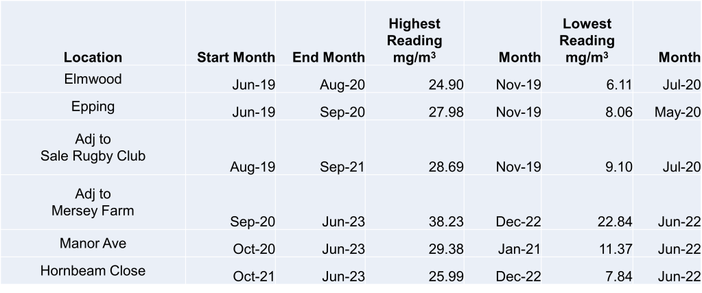
The Friends of Carrington Moss has undertaken air quality monitoring (NO2) at several locations in the area, over a number of years, using diffusion tubes that were sent to an official laboratory.  The readings will be a useful comparison in determining the level of increased emissions if the road is approved. 

We are aware that Carrington Parish Council has invested in an air quality monitor, which covers a range of pollutants, but sadly the readings are not up to date on the website. 

So, who will benefit from the road?

Whilst it is clear that those citizens living in the around 40% of households with no cars will not benefit, we should ask ourselves how much of an advantage it will be for any resident to be at a much greater risk of suffering the extensive health and wellbeing impacts of air, noise, light, vibration, dust and other pollutants, caused by the sheer volume of traffic that will be using this road.