
Why is Trafford pushing ahead with the most harmful route option for the Carrington Relief Road?
By Lorraine Eagling
This summer, we have watched the effects of climate change across the UK, Europe and the rest of the world in horror. Wildfires, flooding, extreme heat and crop failure is sadly a reality. The scientists have said that things will only get worse if we don’t act now by cutting carbon emissions and protecting natures carbon capturing forests and mosses.
This is why we can-not understand why Trafford Council is so determined to destroy Carrington Moss (which Natural England confirms is a restorable irreplaceable habitat), constructing 4 major new roads on, across and around it, turning the Green Belt into Grey Belt and enabling yet more development in an area that is now saturated by ever increasing traffic, congestion and health threatening levels of pollution. At a time when the Council should be following the advice of the scientists by restoring carbon capturing peat mosses (that also act as flood defences) and investing in public transport, they are capitulating to the wishes of the developers and spending £ millions of public monies on unsustainable road solutions.
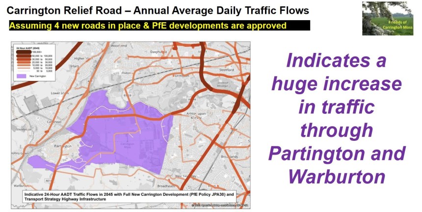
The graphic below, taken from the latest Transport Assessment for the Carrington Relief Road (CRR), shows the predicted average daily traffic flows once the Carrington Relief Road, the Southern Link Road, the Eastern link road and the Sale West Link Road have been built.
Trafford has stated that the CRR will ‘draw’ significant levels of traffic from the M60, the M56, the M6 and the A56. Furthermore, in a recently issued Induced Traffic Technical Note, it states ‘The new trips associated with New Carrington development, plus normal growth of existing trips, will occupy almost all the available Masterplan transport capacity by around 2040’. Effectively, this confirms that over £132million (minimum) will be spent on a new road that will be at capacity in less than 14 years. This is NOT a good use of public money, especially given the significantly negative impact it will have on local communities as described below.
The Friends of Carrington Moss has been doing our own traffic counts for many years. Here we compare the current average daily traffic flows taken from our data with the figures in the graphic above.
Currently the average daily traffic flow on the A6144 between Broadway and Lock Lane in Partington is 7,300 vehicles. In the graphic, it shows that by 2045 the predicted average daily number of vehicles at the same location will be between 20,000 and 30,000.
Also, the average daily traffic flow on the A6144 at the Junction of Warburton Lane and Moss Lane is currently 5,000 vehicles. In the graphic, it shows that by 2045 the predicted average daily number of vehicles at the same location will be between 20,000 and 30,000.
The implications for residents of Partington and Warburton are very concerning. The significant increase in air, noise, light, vibration, dust and water pollution (to say nothing of carbon emissions) will not only have a detrimental effect on their wellbeing but will result in increased prevalence of long-term chronic health conditions, such as asthma, CPOD and cardiovascular disease. These conditions are already a factor for Partington residents, with the Health Inequalities Report (2022) showing significantly higher incidence than the averages for England or Greater Manchester.
Currently, the average daily traffic flow on the Carrington Spur is 25,000 vehicles. By 2045 it is predicted to be anything between 30,000 and 50,000. That means that potentially there will be double the amount of traffic on a road that is already at capacity. Referring to the Junction of the Carrington Spur and Banky Lane, the latest CRR Transport Assessment August 2026 (3.4.41) states ‘it can be concluded that the junction is operating near its absolute capacity with no spare capacity to accommodate additional traffic demands in the peak periods’.
Currently, the average daily traffic flow on Carrington Lane between the Carrington Spur and Flixton Road is 18,000. By 2045 it is predicted to be between 25,000 and 35,000 taking the CRR and the A6144 figures into account. Again, this is almost double the amount of traffic on the local road network which demonstrates that the CRR will reassign traffic onto local roads.
Currently, the average daily traffic flow on Carrington Lane heading towards Sale West is 21,000. By 2045, however, the graphic shows a flow between 10,000 and 20,000. This is unlikely when you consider this figure should include the traffic associated with the development of around 1,500 new homes in Sale West. We will question the source of the figures for the current traffic flows to/from Sale West and Ashton on Mersey as the CRR Project Team appear to have considerably underestimated the volume of traffic.
The community put forward an alternative solution back in 2021. Our option would not result in induced or reassigned traffic because it does not involve building new road capacity. That alternative solution enables much more of the allocated funding to be directed at public transport (very important, given that over 40% of households in parts of Partington and Sale West do not have access to a car, according to ONS data).
The community alternative option, which was created following discussions between FOCM, Parish Councils and other community groups, has been repeatedly presented to Trafford, and, in summary, comprises the following:
- open the existing A1 route to bypass Carrington Village for improved traffic flow and to reduce congestion during peak hours, ensuring a smoother journey for all commuters.
- create a short link (running parallel with Isherwood Road between the A1 junction with Isherwood Road and Carrington Lane) to bypass the new homes on Isherwood Road
- provide upgrades to the existing A6144 (resurfacing, removing potholes, improving signage)
- improve the public rights of way and permitted routes on, across and around Carrington Moss (including resurfacing, low-level wildlife-friendly lighting and better signage), leading to much greater levels of modal shift, encouraging residents to walk, cycle or horse ride using pleasant, healthy and safe alternatives to the road network (peaceful routes with no harmful pollution).
In addition, our community alternative is considerably less environmentally and ecologically harmful than the route currently proposed by Trafford (which causes ‘County-scale’ decline to red listed birds, will remove 40 hectares of Grade 2 agricultural land from food production, is likely to result in flooding of existing and new homes and, as a consequence of changes in hydrology, could cause permanent harm to the 335-hectare peat moss).
Furthermore, we have looked at other initiatives, such as reopening the former railway line and constructing a bridge across the Manchester Ship Canal (something that is now being considered by Trafford elsewhere in the borough).
Sadly, Trafford has repeatedly ignored our alternative option and has chosen the most environmentally damaging option against the advice of Natural England. We have recently discovered that the traffic numbers in the option appraisal which led to the decision about the route of the road were unreliable and that Trafford had dismissed our alternative option because they misunderstood TfGM’s standards for active travel routes.
Given the now very visible impact of climate change, Trafford should be focused on climate mitigation and nature’s recovery, minimising the destruction of, or harms to, the area’s vital natural capital assets! That is why we have formally requested that Trafford Council reconsider the community alternative option in a fair and balanced way.


You must be logged in to post a comment.