There have been numerous concerns raised about the route of the Carrington ‘Relief’ Road across Carrington Moss, as it will cause significant harms to both human and wildlife populations and several of our members have suggested that there is a significant lack of awareness shown by those making the decisions about this proposal.
With this in mind, we hope you will all join us on a walk along the public rights of way near to the Carrington Moss part of the route for the new road. We plan to meet on Dainewell Park on Saturday 8th February at 2pm.
We’d like you to invite your Councillors and your MP to join us on the walk, so we can share our concerns. If you are not sure who your Councillors or your MP are, click on this link to find out. You just need to put in your post code and, hey presto, the information is there. When the details come up, you will see a link at the right-hand side which says “Write to all your Councillors”. You can drop them a note and invite them to come along. If you click on your MP’s name, you can also send an email to him inviting him to come along and hear your concerns about the road. The more invitations the politicians receive, the more likely they are to join us on the walk.
As we mentioned in our previous blog (Call for Action 1 Respond to the Consultation), the Friends of Carrington Moss welcome the long-awaited opening of the A1 route through the employment area of Carrington, but all HGVs should be required to use that route, rather than travelling along the A6144 through Carrington Village. The CRR consultation confirms that “HGVs will not be banned on the A6144” but this should be challenged in consultation responses.
It is disgraceful that Trafford Council have enabled the current situation being experienced by Trafford residents living in Carrington, including the air, noise, light and vibration pollution they are suffering day and night. During the past more than 10 years of planning for unviable and unsustainable growth here, Trafford Council has not identified and/or committed funding for sustainable passenger and freight transport solutions for the area. This is particularly shocking given the anticipated number of HGVs using local roads each day, including those that will carry hazardous materials. There are various alternative options Trafford could have considered, including using the former railway lines, the Manchester Ship Canal and the potential to deploy pipelines (there are several of these in the area already)!
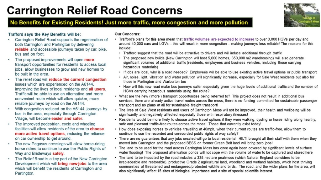
We do, though, have major concerns about the part of the route which runs across Carrington Moss. Not just because of the impact it will cause to Sale West residents and the lack of benefits to surrounding communities, but also because of the harm it will cause to the 335-hectare peat moss (described by Natural England as irreplaceable and restorable), the productive Grade 2 agricultural land, the extensive woodland and the wetland habitats. All of which are essential to a sustainable future for our children and grandchildren. The road, and the wider plans for New Carrington, will also significantly impact 15 sites of biological importance and a site of special scientific significance.
Click here to join our online public meeting on 28th January at 6pm to discuss these issues further. All are welcome.
Finally, despite highlighting previous inaccurate, incomplete or misleading information in CRR materials, the consultation resources (letters and website) have yet more examples. We will be requesting a further Call for Action from local communities. Look out for our next blog for more information on this.
As the first Carrington Relief Road (CRR) consultation goes live today (20th January 2025), we are issuing our first Call for Action to local communities. Please take the time to respond and encourage friends and family to participate too.
The consultation period includes some face-to-face sessions, and we hope you will be able to attend one of these. Just a reminder that the current CRR team are NOT responsible for the decisions made in the past and that they have been directed to give a very limited scope to the consultation, which is only based on the design of the road!
The inadequacies of this consultation have been determined by Trafford Council, and they have repeatedly rejected our requests for communities to be able to influence the wider aspects of transport solutions for the area – our next Call for Action will address this failure (see below).
This consultation ends on 28th February. Your inputs are extremely important, so do click on this link to read Trafford’s materials and submit your own response. We will be discussing this consultation at our next online public meeting on 28th January (6pm),the link to the meeting is hereand all are very welcome to join us.
At the meeting, we will highlight some of the key points to consider, which include the following:
there are two parts to the Carrington Relief Road (CRR):
we are totally supportive of the upgrading of the A1 route in Carrington (this runs through the employment zone from Isherwood Road to the A6144 near Saica Paper), all HGVs should be encouraged to use this road, rather than the A6144 through Carrington Village – this could have come forward years ago without any objections!
we are totally against the development of the road across Carrington Moss and have been proposing our alternative to Trafford for the last 4 years, without success – they are only interested in promoting the CRR, despite its escalating costs – it is a commitment to support development – not a solution aimed at benefiting existing communities
how the current design ‘benefits’ communities:
Carrington residents will only benefit from this new road if through-traffic and HGVs are unable to use the A6144 through the village, with appropriate traffic calming mechanisms put in place (otherwise, residents here will just be surrounded by constant traffic and the associated pollutant impacts)
Partington and Warburton residents will, sadly, not benefit from the scheme – Trafford has acknowledged that the road will induce additional traffic, much of which is likely to continue through Partington and Warburton, seeking an alternative route to the motorways, furthermore, given the low levels of car ownership in Partington, a new road will not reduce the isolation of this community (unlike a tram/train connection)
Sale West residents will be the most negatively affected by the scheme, they will suffer from huge increases to air, noise, light, vibration and water pollution, a significant, intensified and more frequent risk of local flooding, and the loss of the current safe, healthy and pleasant traffic-free recreational routes – we recognise that the recorded and unrecorded public rights of way will still be there, but, with the road solution, residents will be walking, cycling and horse riding next to the over 40,000 motor vehicles expected to use the road each day (including over 3,000 HGVs) – the number of vehicles will significantly increase from the current traffic numbers due to the proposed developments in the area and the induced traffic using the road as a ‘rat-run’!
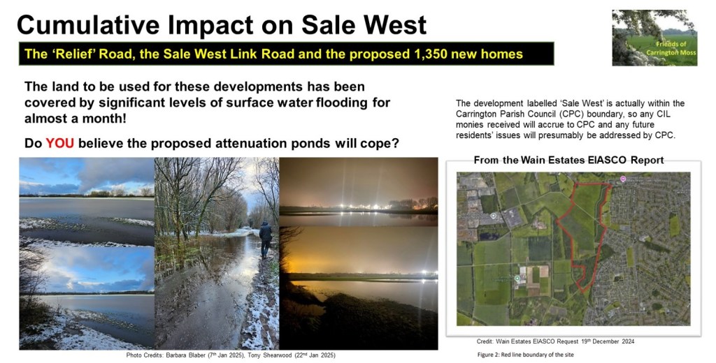
Urmston residents will not benefit from the scheme either, but they are also likely to see an increase in traffic on their local roads and the risk of local flooding will increase due to the loss of water capture and storage on Carrington Moss (we do not believe the proposed attenuation ponds will be sufficient to replace the capacity lost when the road is built)
how the design ‘mitigates and compensates for the impact on the natural environment’:
the part of the road that cuts across Carrington Moss will severely impact red listed birds (including, for example, the skylark, which is prevalent along the route of the road) and protected/endangered species – we are very saddened by the thought of yet more roadkill!
the road will fracture the corridors used by wildlife and birds to access food and water sources – this will result in further depletion of their species
the road will also damage the peat moss (a restorable 335-hectare irreplaceable habitat according to Natural England) and the sites of biological importance/site of special scientific interest, even where these are not directly impacted – this is because of the changes to hydrology that will be required to keep the road water-free
it is likely that Trafford will consider that the attenuation ponds will replace the immense water capture and storage functionality of the moss – we think they underestimate the level of water captured here and this could lead to huge risks for local communities
Trafford is also likely to assume that these pond areas will create biodiversity gains, but what must be considered is that the losses will be experienced immediately, whereas any gains could take years to deliver, and, in that time, species will be lost to the area forever
the road will also impact the potential opportunities to support the Local Nature Recovery Strategy
the loss of productive Grade 2 agricultural land will impact future food security as this cannot be replaced elsewhere in Trafford
how the design constrains the development of the New Carrington Masterplan which is currently under development and covers the whole allocation area:
the CRR will significantly restrict and constrain what is possible in terms of recreational, ecological and natural capital benefits for the Sale West area, considerably increasing the inequities of access to green space for residents
the Natural Infrastructure Strategy underpinning the Masterplan has not yet even been discussed – this should determine the approach to mitigation and compensation for environmental and ecological harms to be caused across the allocation area (including the cumulative harms) – such issues should not be addressed as piecemeal solutions for individual developments, including the CRR.
Whilst we are keen for residents to respond as constructively as possible to this consultation, we also need to recognise that Trafford has not given communities the opportunity to influence either:
the choice of transport options for this area (why weren’t we asked if we wanted trams or trains, given the size and scale of the developments they are proposing, the number of years this has been under consideration, and the sheer common sense that we should make full use of the former railway lines running through the allocation area and the proximity of the Manchester Ship Canal?), or
the route options for the road.
You might want to mention this in the final section of the response questionnaire (headed “Further Comments / Queries), but with these things in mind, there will be a future Call for Action from local communities to address the total lack of previous consultation about the CRR.
Look out for our next blog for more community action on the Carrington Relief Road Consultation.
Whilst we await the consultation for the Carrington Relief Road (CRR), we continue to collect data and scrutinise the traffic flows in our locality. Our analysis is very revealing! So, why are we worried about the impact of the CRR? Read on to understand our concerns. Contact your Councillors if you are concerned too (details of your Councillors can be found here).
Trafford Council has acknowledged that the construction of this £76million road is not for the benefit of existing residents (as stated in their Carrington Relief Road Environmental Impact Scoping Report)
“1.2. The key objective of the new Carrington Relief Road is to provide sufficient capacity within the transport network to deliver growth of housing and employment in the wider New Carrington masterplan area, and realise the socio-economic benefits of the future development. The redevelopment of this Site provides an opportunity to deliver a new link road for Trafford that will facilitate future phased development of c.5,000 new homes and 360,000sqm employment floorspace”.
Unfortunately, existing residents will be adversely affected by the new road as demonstrated below. Yet, if monies were invested in public transport infrastructure, as previously promised in the local plan, there would be far greater health, economic and social benefits for both existing and new residents, not to mention the preservation of an area that supports climate mitigation, nature’s recovery and future food security.
So, why are there no plans to invest in train/tram infrastructure in what is the largest development in the Places for Everyone Plan? It is described as the single largest regeneration scheme in the North West by Andrew Western, MP for Stretford and Urmston in his comment supporting the Wain Estates Case Study here.
Trafford Council’s Local Plan 2012 proposed to deliver “significant improvements to public transport infrastructure by improving access to Partington, the Regional Centre and Altrincham with links to the Metrolink system”. The New Carrington Masterplan presents the perfect opportunity to deliver these much-needed improvements by directing the funding into schemes that already had the backing of the local businesses, Councils and the community, such as reopening the Cadishead Viaduct. More information on that initiative can be found here.
Whilst we understand that funding is an issue and the Council are reliant on contributions from developers and the government, these types of schemes are long-term, sustainable solutions to the inequalities that exist in Partington, Carrington and Sale West and are a much better use of public money. It is well documented that roads are short-term, unsustainable options.
We are already experiencing the impact of climate change, with erratic weather patterns leading to localised flooding and crop failure. The proposals for New Carrington are contrary to Trafford’s declaration of a climate emergency in 2018 and its aims to be net zero by 2038. The lack of funded sustainable transport options also conflicts with the Greater Manchester Transport Strategy 2040, which has a vision for 50% of trips to be made by sustainable modes, and states (page 8) that “Achieving the Right Mix is expected to lead to zero net growth in motor vehicle traffic in Greater Manchester between 2017 and 2040”).
How will they meet these targets?
Whilst we acknowledge active travel forms part of the transport intervention in New Carrington, any progress made in getting people to choose active modes will be heavily outweighed by the significant increase in road traffic as described in their scoping report. Walking cycling or horse riding next to over 3,000 HGVs a day will not be pleasant, safe or healthy!
The Proposed Road
The western end of the Carrington Relief Road starts opposite the Saica Paper Factory and will run along the existing A1 Road behind Carrington Village. This road is to be upgraded as part of the scheme. The eastern end of the Relief Road will be constructed across Carrington Moss, from Isherwood Road to the junction of the Spur Road and Banky Lane.
The cost of the overall scheme is currently estimated at £76 million but could rise due to the increased cost of materials, the need to address contamination and the complexity of building on or near to a 335 hectare peatmoss (hydrology issues will need to be tackled – depending on the final route).
In responding to Trafford’s ‘engagement event’ (which took place in 2021), in advance of the release of the CRR route options report, we put forward a proposal that would reduce HGV traffic through Carrington Village and negate the need to construct an expensive road across Grade 2 agricultural land, woodland and wetland habitats.
We proposed that the existing A1 Road be upgraded and opened up to all heavy goods vehicles to resolve the issue of hundreds of HGVs passing through Carrington Village every day. We proposed upgrading the existing A6144 between Isherwood Road and the Carrington Spur, which is not at capacity, and reducing speed limits. We also proposed upgrading the existing active travel routes across Carrington Moss.
Unfortunately, our suggestions (and those of Natural England – a national organisation that advises the government on all issues related to the natural environment), were ignored. So, we have continued to collect traffic data and here is a summary of our findings:
Induced Traffic
Our most recent surveys focused on the pattern of traffic travelling from the west of Partington towards the M60.
During term time, the total number of cars travelling from Warburton, Warrington and Lymm into Partington is 69% of the total number of cars recorded leaving Partington in the direction of Carrington. During school holidays, this figure is 63%. This shows that the majority of the traffic travelling through Partington towards Carrington is coming from outside the area. The volume of this induced traffic will increase (as described in Trafford’s own Environmental Scoping Report – “Traffic flows are likely to increase due to the improved desirability of the route” paragraph 14.46)
What proportion of traffic will benefit from the new road
At the Manchester Road/Isherwood Road and Carrington Spur/Banky Lane junctions term time figures have been used, when traffic is highest. Full details of our surveys can be found here and here.
During term time 37% of the traffic coming from the M60 is headed towards Carrington.
During term time 40% of the traffic from Sale West is headed towards Carrington
During term time 53% of the traffic from M60 or Sale West is headed towards Flixton.
The traffic headed towards Flixton would not use the relief road, so ……
….. only 18.1% (an average of 47% of 37% and 47% of 40%) of the traffic from the M60 and Sale West would use the new relief road.
Furthermore – during term time ……
….. only 32%of the traffic from Partington and Carrington heading towards the M60 would use the new road, as the rest of the traffic is headed towards Flixton.
Let’s think about that – only 18.1% of the traffic from the M60 and Sale West and only 32% of the traffic from Partington and Carrington would use the CRR – yet the Council is proposing to spend £76m on an outdated, unsustainable road-based solution!
Remember:
Congestion in Partington will increase significantly and will have a major impact on existing residents. Not only will there be increased induced traffic as described earlier, but the construction of approximately 3600* houses in central Partington, Partington East (which is really Carrington South) and Warburton will put extreme pressure on the road network – note that these numbers do not include the additional homes recently constructed or still to be built in other parts of Partington (Lock Lane, Oak Lane, Hall Lane).
Congestion from Sale West to the M60 at the Banky Lane Junction is the heaviest of all routes during peak times. This will increase significantly due to induced traffic from the relief and the construction of 1450* houses in Sale West.
If you wish to express your opinion regarding this matter, the public consultation for the Carrington Relief Road is due to commence in the coming weeks. You can also join the discussions at our monthly online public meetings – you will find the link to the next meeting here. As mentioned above, you can also email your local Councillors to outline your concerns.
Committee member, Lorraine Eagling, reviews the agenda item relating to the plan for the Carrington Relief Road, which was discussed at Trafford’s Scrutiny Committee on 13th March 2024. A link to the recording (from 47:49 minutes) can be found here and the report is available here.
The new part of the relief road will be constructed across farmland, parallel to the A6144 between Isherwood Road and the Carrington Spur. In the presentation to the Scrutiny Committee the new road was described as ‘not a big road’ (despite previous suggestions that it would be a dual carriageway). The main carriageway that carries motor traffic will be 7.3 metres wide and there will be 5 metres on either side for active travel (2.5m for pedestrians and 2.5m for cyclists), so a total of 17.3 metres wide.
This field, which grew potatoes last year, will be sacrificed for the road and for housing
It is really encouraging to see that pedestrians and cyclists are given so much consideration, but would residents want to walk, let alone cycle beside a major road that carries over 3,000 heavy goods vehicles a day, along with a huge number of cars?
Would an active travel corridor that runs parallel to the existing road be a better option? We think it would!
And what about horse riders, we have over 1,000 horses stabled on and around Carrington Moss! We have repeatedly raised their needs with Trafford and yet they still don’t even get a mention in this presentation! At least one of the stables provides services to children with special educational needs. Those children will not be able to ride near to the thousands of motor vehicles that will be travelling along the Carrington Relief Road every day, the noise alone will be an issue. They currently have lots of options for circular routes along the very safe and very quiet public rights of way, short circuits or longer rides. The road is going to fracture their routes and reduce the opportunities for these very vulnerable members of our community.
The Scrutiny Committee were given a presentation on the history of New Carrington, which showed that since the closure of the railway line in the 1980’s, Partington and Carrington have become increasingly isolated and car dependant. Several Councillors raised the question of why sustainable options aren’t being re-introduced like re-opening the old railway bridge to allow for a light rail or full rail link between Irlam and Timperley. Councillor Holden explained that this idea has been around for some considerable time because a bridge was built in Broadheath so that this train line would remain viable. We know that former MP, Kate Green, with the backing of the residents of Partington and Carrington, lobbied Parliament about re-opening the line, so it is not new to Government.
Now that HS2 has been scrapped, shouldn’t this be something the GMCA and Trafford Council actively pursues? Especially when New Carrington is the largest development in the Greater Manchester Spatial Framework (frustratingly, New Carrington is described by executive members as ‘one of the largest brownfield sites in Greater Manchester’, which is highly misleading given the majority of the brownfield land already has planning approval and 169 hectares of greenbelt will be released for the development of housing, warehousing and roads, affecting a 335 hectare peatmoss, Grade 2 agricultural land, woodland and wetland habitats).
Interestingly, Stockport Council, which pulled out of GMCA’s Places for Everyone (PfE) Plan in order to protect its greenbelt, is now in talks with TfGM and GMCA to have the Metrolink extended to their new transport interchange.
So, as the largest site in the PfE Plan, why isn’t New Carrington being prioritised for such sustainable transport investment, especially when it is described as the ‘Western Gateway’?
In a recent traffic survey, carried out by Friends of Carrington Moss, during peak times we recorded approximately 50% of the traffic coming from the M60 going towards Carrington and less than 50% of the traffic from Carrington headed towards the M60. In fact, approximately 50% of the traffic coming from the M60 is headed towards Sale West and over 60% of the traffic from Carrington and Partington headed towards Flixton. Full details of our survey can be found in my previous blog here.
During term time, peak time traffic increased by approximately 500% and there was significant traffic queuing from the M60 to Sale West and from Sale West to the M60. There was no queuing traffic in other directions or at other junctions.
In essence, only half of the traffic surveyed used the existing A6144, which the new road aims to relieve! It is evident that the main cause of congestion is school traffic which could be reduced by reviewing Trafford’s school admissions policy and providing school buses. Shouldn’t the Council tackle this issue instead of spending £76.5 million on a road that only 50% of existing traffic will use and that will offer no relief to the residents of Partington and Sale West as explained in my previous blog?
At the Scrutiny meeting, Councillors also raised the issue of how the Council will raise in excess of £54 million of public money for the relief road. The Council’s Director of Growth & Regulatory Services, Adrian Fisher, acknowledged the risks and explained that when the planning committee addressed all of the infrastructure needs of New Carrington, which includes all roads, schools, playing fields etc, they decided that in theory there is enough funding from developers to meet needs. He explained that the main issue is with the sequencing of the funding, that where the main risks arise is getting the first bit of infrastructure up and running.
Sequencing is definitely an issue, as it’s the chicken or the egg scenario. Developers’ contributions are based on all development completed, but they won’t develop all sites unless the relief road is built! Mr Fisher describes the site as the biggest in Greater Manchester and it will not able to deliver houses unless the road is built!
So, at what point will the developers make their contribution? Trafford have recently had their fingers burnt when it comes to developers Section 106 contribution. Also, as mentioned in the meeting, the developer contributions are not only for this road, but for other roads that will be needed for this huge site, for schools and other community facilities. Will the developer contributions be enough for all this infrastructure? The answer is a definite NO!
Councillor Carter asked how the new road would impact the peat land to the south of the proposed carriageway, in particular relating to drainage. Mr Fisher acknowledged that there is significant peat in the south part of the site and that this will be an issue when it comes to development in that area and will be an important consideration.
We know how important peat moss is, so much so that the Government is investing in peat restoration to fight climate change. With this in mind, why would Trafford Council give planning permission to build on this precious habitat? The answer is that they are wedded to building a road, rather than advancing more sustainable options and, if they don’t give planning permission, they will not get the developers’ contributions towards the costs of the road.
Councillor Holden raised the issue of extensive contamination, and now there is the recent discovery of PFAS (Per-and polyfluoroalkyl substances) on the site. Mr Fisher acknowledged that this will be addressed when building the new road and this is why the costs of the road has increased significantly. He explained that a separate drainage system is needed to avoid contamination of groundwater as a result of run off from the road. It was confirmed that the Council will be working with the land owner/developer and the Environment Agency to come up with a solution that avoids flushing out contaminants into local watercourses and environment. We know that this area is particularly sensitive for the water environment given its location above a principal aquifer and nearby surface waters including the River Mersey and Sinderland Brook, so it is vital any contamination risks are appropriately remediated.
So, what will the true cost of the Carrington Relief Road be? Not just in financial terms but in relation to the ecology and biodiversity of the area, in relation to the health and wellbeing of residents and in relation to climate mitigation issues that will impact future generations, our children and our grandchildren?
Lorraine Eagling looks at what the Strategy means to residents given today’s traffic volumes!
It’s without question that a transport strategy is desperately needed by the residents of Carrington, Partington, Sale West, Warburton and Ashton on Mersey even before the plans for New Carrington get underway, so it was encouraging when Trafford Council published The New Carrington Transport Strategy but very disappointing that no residents had been involved in its development.
The residents of these isolated and poorly served towns have long been promised and waited for a plan that provides the transport solutions they deserve, that are sustainable and will provide long term options for existing residents and for future generations.
The Strategy describes all the sustainable options (scenario 3) that would provide residents with regular and reliable connectivity to the rest of Manchester. Solutions that would provide the residents with access to trains and trams and reduce traffic on local roads. The Strategy goes on to explain, however, that these long-awaited public transport services are not an option because they are too expensive to implement and the only affordable option is a relief road, now expected to cost a minimum of £76.5m (and that is before any resident requirements such as additional junctions, crossings and traffic calming measures, for example are included in the design). Reminiscent of Bullseye’s infamous phrase ‘look at what you could have won!’, residents have once again been let down.
The proposed relief road will run along the existing A1 Road, which starts opposite the Saica paper factory, to Isherwood Road. From here a new road will be constructed adjacent to the peat moss and across the farmland to meet the Carrington Spur Road at the junction with Carrington Lane in Sale West. The new section of the road will have massive implications to the environment. More details about the impact of the CRR can be found at this link, where you can look at our many previous blogs about the Carrington Relief Road by scrolling down the web page.
It’s a very disappointing outcome and it is questionable when the following is taken into consideration:
There is no mention of HGV traffic anywhere in the report. As we know, the huge number of HGVs is the main concern for residents in Carrington Village and beyond.
The traffic data used in the report is taken from TfGM 2017 base year, which is outdated and pre-covid. Considering the implications of this Strategy, the data should be current. It is not clear whether any actual traffic monitoring has been done at key locations in order to access what road interventions would have the greatest benefit.
In addition to the outdated TfGM data, the Strategy interpreted daily travel modes from evidence of what it describes as ‘comparable brownfield’ development sites in South Gloucestershire, including areas of Stoke Gifford, Bradley Stoke, Patchway and Filton, on the northern edge of Bristol. These sites have their own train stations and are home to industries such as aerospace and hi-tech engineering. This is hardly comparable to New Carrington, Partington, Warburton and Sale West, where there are no train stations and the main industry is HGV intensive warehousing and logistics. Also, New Carrington is not just brownfield, it is green belt, comprising peatmoss, woodlands, wetlands and grade 2 agricultural land.
What about the traffic data?
We have been collecting our own traffic data at key junctions in Carrington and Sale West for several years, but to verify the figures in the report, we collected some specific data in February and March 2024. The results of our survey are as follows:
Cars and Vans
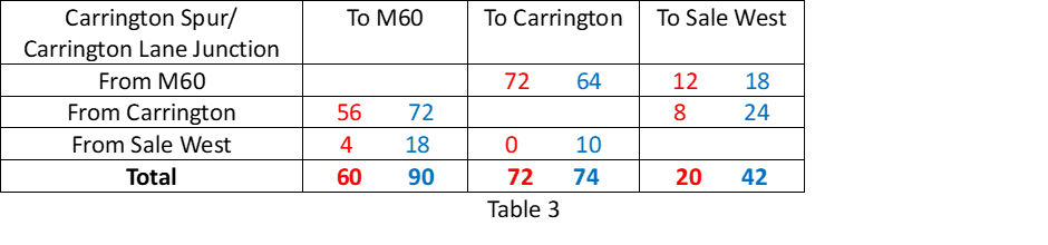
Table 1 shows the average number of cars per hour, during peak times, at the junction of the Carrington Spur and Carrington Lane in Sale West. The red data was recorded during school term time and the blue data was recorded during school holidays.
As expected, the number of cars increases around this junction during term time. The data shows during term time there are almost four times as many cars travelling from the M60 to Sale West. Also, the number of cars travelling from Carrington to Sale West is more than double during term time and the number of cars travelling from Sale West to Carrington is more than tripled.
On average, a total of 2,728 cars pass through this junction during peak times. During term time, 48% of the car traffic from the M60 is heading towards Sale West and 43% of the traffic heading towards the M60 is from Sale West. Additionally, 39% of the traffic from Carrington is heading towards Sale West and 47% of the traffic from Sale West is heading towards Carrington.
Other observations at this junction are:
Traffic queuing along the Carrington Spur Road from the M60.
Traffic queuing along Carrington Lane towards the M60.
Other routes were flowing freely.
2 buses maximum during the survey period.
Table 2 shows the average number of cars per hour during peak times at the junction of the A6144, Flixton Road and Isherwood Road in Carrington. The red data was recorded during school term time and the blue data was recorded during school holidays.
As expected, car traffic increases during term time, with the exception of those vehicles headed towards Isherwood Road. During term time the car traffic from Carrington to Flixton increases by almost five times. 62% of the car traffic from Carrington is headed towards Flixton. It is also interesting to see that 36% of the traffic headed towards the M60 is from Flixton.
Other observations at this junction are:
All traffic was flowing and there was no queuing at any junction.
Some traffic was travelling at excessive speeds, including HGVs.
3 buses maximum during the survey period.
According to the data in the Transport Strategy, 875 cars travel from Partington and Carrington to Urmston (the report does not mention Flixton) on a daily basis. We recorded 678 in one hour during one peak time and 282 and hour during non-peak time. It suggests that the data in the report is an underestimation for traffic moving in this direction.
The data in the transport strategy is not as specific as the data we collected but assuming the traffic from Carrington and Partington heading to ‘Sale West’ and ‘10km inside GM’ is the traffic headed towards M60, then their data suggests there are 10,587 cars per day travelling along the A6144 between Isherwood Road and the Carrington Spur Road. Our data shows 663 cars during peak time and 502 cars during non-peak time per hour. Assuming two peak times and 10 hours of non-peak traffic, that is a total of 6,346 cars travelling along this route. This time, the data in the report seems an over-estimation for cars travelling along this section of the A6144.
We will repeat our traffic count in the coming months, to test the validity of this result.
HGV Traffic
The data shows that during peak times there are approximately 152 heavy goods vehicles at the Carrington Spur junction and 213 at the Isherwood Road junction per hour. At non-peak times, there are 208 and 206 respectively. This suggests that HGV traffic is consistent irrespective of peak or non-peak times and is in excess of 2,000 per day. This figure will increase significantly as the proposed new warehousing is built.
Conclusions
Our data shows that:
The A6144 Carrington Lane in Sale West has as much car traffic as the A6144 in the direction of Carrington, as 48% of the traffic from the M60 turns towards Sale West during peak times.
The A6144 between Isherwood Road and the Carrington Spur has less car traffic than that suggested in the report.
There was no queuing traffic at the junction of the A6144 and Flixton Road during peak time. There was, however, significant queuing on the Carrington Spur and on Carrington Lane.
There is a massive increase in car traffic during term time indicating that there is insufficient public transport for students to get to school and a large proportion of students are travelling to schools from either outside the catchment area or from outside the borough.
Considering the findings of this data, how will the relief road reduce the traffic issues highlighted?
The biggest issue for the residents of Carrington Village has always been the large number of heavy goods vehicles that pass their front door every day. The existing A1 Road could be opened immediately to redirect HGVs away from the village. This would be a quick win (if the businesses in Carrington are willing to use that road).
Partington is experiencing housing development on a huge scale. The new developments on Lock Lane, Hall Lane, Oak Road, Heath Farm Lane and the Greyhound will create another 1,291 dwellings. Despite these developments increasing the number of houses in Partington by 38%, the routes in and out of Partington will remain the same. Only after the cars and buses have contended with the congestion in Partington itself, can they access the proposed relief road further along the A6144.
For residents in Sale West and Ashton on Mersey to benefit from the proposed relief road to Carrington, they will have to access it from Carrington Lane which is already heavily congested even before the new relief road joins this junction.
In essence, residents in Carrington Village will only benefit if HGV traffic moves onto the existing A1 Road. Residents in Partington, Sale West and Ashton on Mersey will have to queue in traffic in their towns before they can access the relief road. The new relief road, which will cost at least £76 million offers no relief to these residents who will see the population in their area increase significantly as a result of the Places for Everyone Plan. There will be an additional 2,260 houses in Partington and Warburton, 1,443 in Sale West (in addition to the 263 already with planning permission) and 603 in Carrington Village.
So how can this Transport Strategy justify such significant expenditure on a road that offers no solution to traffic issues that already exist?
There are other considerations here too:
Why hasn’t the A1 Road already been opened to HGV traffic to resolve the issues in Carrington Village?
Why are so many students being driven to school?
Do the school admissions policies in Trafford need reforming?
Does the Education authority or TfGM need to look at providing school buses?
The data shows that it is school traffic and heavy goods vehicles that create the congestion along the A6144. These are the issues that need addressing rather than spending £76 million on a scheme that will not solve the transport issues that have plagued this area for decades. This money could contribute towards the ‘scenario 3’ solution in the Transport Strategy and should be invested in long term, sustainable passenger and freight transport interventions.
There are several options that could be considered, such as:
opening the railway bridge between Irlam and Partington to give residents access to trains
opening up the ‘greenway’ and the former railway line from Partington to Altrincham to give residents access to trams
revisiting the 2012 Local Plan option to build a bridge from Carrington to Port Salford.
These are long term sustainable options that will reduce congestion and open up Greater Manchester and the rest of the UK to residents of these local areas.
What we need is a Transport Strategy that meets residents’ requirements, why isn’t Trafford talking to us about it?


You must be logged in to post a comment.