
New Carrington Transport Strategy
Lorraine Eagling looks at what the Strategy means to residents given today’s traffic volumes!
It’s without question that a transport strategy is desperately needed by the residents of Carrington, Partington, Sale West, Warburton and Ashton on Mersey even before the plans for New Carrington get underway, so it was encouraging when Trafford Council published The New Carrington Transport Strategy but very disappointing that no residents had been involved in its development.
The residents of these isolated and poorly served towns have long been promised and waited for a plan that provides the transport solutions they deserve, that are sustainable and will provide long term options for existing residents and for future generations.
The Strategy describes all the sustainable options (scenario 3) that would provide residents with regular and reliable connectivity to the rest of Manchester. Solutions that would provide the residents with access to trains and trams and reduce traffic on local roads. The Strategy goes on to explain, however, that these long-awaited public transport services are not an option because they are too expensive to implement and the only affordable option is a relief road, now expected to cost a minimum of £76.5m (and that is before any resident requirements such as additional junctions, crossings and traffic calming measures, for example are included in the design). Reminiscent of Bullseye’s infamous phrase ‘look at what you could have won!’, residents have once again been let down.
The proposed relief road will run along the existing A1 Road, which starts opposite the Saica paper factory, to Isherwood Road. From here a new road will be constructed adjacent to the peat moss and across the farmland to meet the Carrington Spur Road at the junction with Carrington Lane in Sale West. The new section of the road will have massive implications to the environment. More details about the impact of the CRR can be found at this link, where you can look at our many previous blogs about the Carrington Relief Road by scrolling down the web page.
It’s a very disappointing outcome and it is questionable when the following is taken into consideration:
- There is no mention of HGV traffic anywhere in the report. As we know, the huge number of HGVs is the main concern for residents in Carrington Village and beyond.
- The traffic data used in the report is taken from TfGM 2017 base year, which is outdated and pre-covid. Considering the implications of this Strategy, the data should be current. It is not clear whether any actual traffic monitoring has been done at key locations in order to access what road interventions would have the greatest benefit.
- In addition to the outdated TfGM data, the Strategy interpreted daily travel modes from evidence of what it describes as ‘comparable brownfield’ development sites in South Gloucestershire, including areas of Stoke Gifford, Bradley Stoke, Patchway and Filton, on the northern edge of Bristol. These sites have their own train stations and are home to industries such as aerospace and hi-tech engineering. This is hardly comparable to New Carrington, Partington, Warburton and Sale West, where there are no train stations and the main industry is HGV intensive warehousing and logistics. Also, New Carrington is not just brownfield, it is green belt, comprising peatmoss, woodlands, wetlands and grade 2 agricultural land.
What about the traffic data?
We have been collecting our own traffic data at key junctions in Carrington and Sale West for several years, but to verify the figures in the report, we collected some specific data in February and March 2024. The results of our survey are as follows:
Cars and Vans
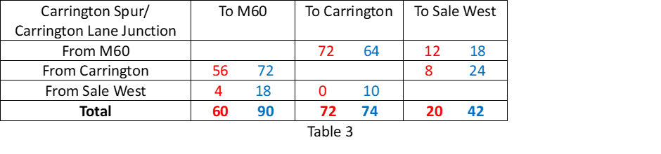
Table 1 shows the average number of cars per hour, during peak times, at the junction of the Carrington Spur and Carrington Lane in Sale West. The red data was recorded during school term time and the blue data was recorded during school holidays.

As expected, the number of cars increases around this junction during term time. The data shows during term time there are almost four times as many cars travelling from the M60 to Sale West. Also, the number of cars travelling from Carrington to Sale West is more than double during term time and the number of cars travelling from Sale West to Carrington is more than tripled.
On average, a total of 2,728 cars pass through this junction during peak times. During term time, 48% of the car traffic from the M60 is heading towards Sale West and 43% of the traffic heading towards the M60 is from Sale West. Additionally, 39% of the traffic from Carrington is heading towards Sale West and 47% of the traffic from Sale West is heading towards Carrington.
Other observations at this junction are:
- Traffic queuing along the Carrington Spur Road from the M60.
- Traffic queuing along Carrington Lane towards the M60.
- Other routes were flowing freely.
- 2 buses maximum during the survey period.
Table 2 shows the average number of cars per hour during peak times at the junction of the A6144, Flixton Road and Isherwood Road in Carrington. The red data was recorded during school term time and the blue data was recorded during school holidays.

As expected, car traffic increases during term time, with the exception of those vehicles headed towards Isherwood Road. During term time the car traffic from Carrington to Flixton increases by almost five times. 62% of the car traffic from Carrington is headed towards Flixton. It is also interesting to see that 36% of the traffic headed towards the M60 is from Flixton.
Other observations at this junction are:
- All traffic was flowing and there was no queuing at any junction.
- Some traffic was travelling at excessive speeds, including HGVs.
- 3 buses maximum during the survey period.
According to the data in the Transport Strategy, 875 cars travel from Partington and Carrington to Urmston (the report does not mention Flixton) on a daily basis. We recorded 678 in one hour during one peak time and 282 and hour during non-peak time. It suggests that the data in the report is an underestimation for traffic moving in this direction.
The data in the transport strategy is not as specific as the data we collected but assuming the traffic from Carrington and Partington heading to ‘Sale West’ and ‘10km inside GM’ is the traffic headed towards M60, then their data suggests there are 10,587 cars per day travelling along the A6144 between Isherwood Road and the Carrington Spur Road. Our data shows 663 cars during peak time and 502 cars during non-peak time per hour. Assuming two peak times and 10 hours of non-peak traffic, that is a total of 6,346 cars travelling along this route. This time, the data in the report seems an over-estimation for cars travelling along this section of the A6144.
We will repeat our traffic count in the coming months, to test the validity of this result.
HGV Traffic

The data shows that during peak times there are approximately 152 heavy goods vehicles at the Carrington Spur junction and 213 at the Isherwood Road junction per hour. At non-peak times, there are 208 and 206 respectively. This suggests that HGV traffic is consistent irrespective of peak or non-peak times and is in excess of 2,000 per day. This figure will increase significantly as the proposed new warehousing is built.
Conclusions
Our data shows that:
- The A6144 Carrington Lane in Sale West has as much car traffic as the A6144 in the direction of Carrington, as 48% of the traffic from the M60 turns towards Sale West during peak times.
- The A6144 between Isherwood Road and the Carrington Spur has less car traffic than that suggested in the report.
- There was no queuing traffic at the junction of the A6144 and Flixton Road during peak time. There was, however, significant queuing on the Carrington Spur and on Carrington Lane.
- There is a massive increase in car traffic during term time indicating that there is insufficient public transport for students to get to school and a large proportion of students are travelling to schools from either outside the catchment area or from outside the borough.
Considering the findings of this data, how will the relief road reduce the traffic issues highlighted?
The biggest issue for the residents of Carrington Village has always been the large number of heavy goods vehicles that pass their front door every day. The existing A1 Road could be opened immediately to redirect HGVs away from the village. This would be a quick win (if the businesses in Carrington are willing to use that road).
Partington is experiencing housing development on a huge scale. The new developments on Lock Lane, Hall Lane, Oak Road, Heath Farm Lane and the Greyhound will create another 1,291 dwellings. Despite these developments increasing the number of houses in Partington by 38%, the routes in and out of Partington will remain the same. Only after the cars and buses have contended with the congestion in Partington itself, can they access the proposed relief road further along the A6144.
For residents in Sale West and Ashton on Mersey to benefit from the proposed relief road to Carrington, they will have to access it from Carrington Lane which is already heavily congested even before the new relief road joins this junction.
In essence, residents in Carrington Village will only benefit if HGV traffic moves onto the existing A1 Road. Residents in Partington, Sale West and Ashton on Mersey will have to queue in traffic in their towns before they can access the relief road. The new relief road, which will cost at least £76 million offers no relief to these residents who will see the population in their area increase significantly as a result of the Places for Everyone Plan. There will be an additional 2,260 houses in Partington and Warburton, 1,443 in Sale West (in addition to the 263 already with planning permission) and 603 in Carrington Village.
So how can this Transport Strategy justify such significant expenditure on a road that offers no solution to traffic issues that already exist?
There are other considerations here too:
- Why hasn’t the A1 Road already been opened to HGV traffic to resolve the issues in Carrington Village?
- Why are so many students being driven to school?
- Do the school admissions policies in Trafford need reforming?
- Does the Education authority or TfGM need to look at providing school buses?
The data shows that it is school traffic and heavy goods vehicles that create the congestion along the A6144. These are the issues that need addressing rather than spending £76 million on a scheme that will not solve the transport issues that have plagued this area for decades. This money could contribute towards the ‘scenario 3’ solution in the Transport Strategy and should be invested in long term, sustainable passenger and freight transport interventions.
There are several options that could be considered, such as:
- opening the railway bridge between Irlam and Partington to give residents access to trains
- opening up the ‘greenway’ and the former railway line from Partington to Altrincham to give residents access to trams
- revisiting the 2012 Local Plan option to build a bridge from Carrington to Port Salford.
These are long term sustainable options that will reduce congestion and open up Greater Manchester and the rest of the UK to residents of these local areas.
What we need is a Transport Strategy that meets residents’ requirements, why isn’t Trafford talking to us about it?

Brilliant report. No doubt it has been sent to Trafford Council – does anyone there actually take notice? – and I would suggest sending it to The Manchester Mill, whose report on the Plan’s acceptance was very much a “Can we get on with it now please” response.
LikeLike
Exactly what Lorraine plans to do 🙂
LikeLiked by 1 person
Pingback: What will be the true cost of the Carrington Relief Road? | Friends of Carrington Moss
Pingback: Is the Carrington Relief Road really a relief road or just a green light to major development? | Friends of Carrington Moss
Pingback: Concerned about traffic? Email your Councillors about the Carrington Relief Road! | Friends of Carrington Moss