Unsustainable New Carrington – “Trapped Behind the Wheel”

by Lorraine Eagling

Where we live and how we get around are key to what shapes our everyday lives.  A recent New Economics Foundation (NEF) report ‘Trapped Behind the Wheel’ found that

far from moving our economy towards sustainability and improved wellbeing, England’s new homes in recent years have increasingly encouraged car-dependent lifestyles.

One factor in this change has been the outsized share of new homes being built in rural areas, which has risen continually across the country in recent years”.

New Carrington will be one of these car and HGV-dependent developments that will not be sustainable, nor will it deliver improved wellbeing for new and existing residents.  The majority of the housing and warehousing will be located on grade 2 agricultural land and part of a restorable 335 hectare peatmoss! 

Despite the proximity of New Carrington to Partington, Carrington and Sale West, there is currently a lack of adequate public transport and no committed funding for new public transport infrastructure.  In fact, there are no plans to connect New Carrington to the water, rail or tram network, despite the allocation being adjacent to the Manchester Ship Canal, having former railway lines running through the site and it being the largest development in Greater Manchester.

The Council are pushing ahead with this plan regardless of the experience of the past 15 years, which shows us that, without substantial changes and investment into new public transport infrastructure, there is a major risk of locking in increased car and HGV dependency for decades to come.

As a result, Trafford Council and the Government will not be able to deliver priorities such as

Bringing the cost of living down to more manageable levels, reducing spatial inequality and responding adequately to the climate emergency

In most cases, residents in New Carrington will face the higher costs of car dependent living. Their ability to enter paid employment or the training needed to secure a well-paid job is constrained by the availability of local public transport infrastructure.  

Although there are plans to improve bus services as part of the masterplan, Partington, Carrington and Sale West have seen bus services reduce significantly over recent years, so any increase in services provides no net gain overall. 

“A 2021 study demonstrated that in ‘left-behind’ neighbourhoods, which have high deprivation and poor social infrastructure provision, public transport is worse than average (74% have no railway station and bus journeys per capita have declined faster than the national average). Residents are less able to afford to compensate by owning a car (40% of households have no car, compared with 26% across England). These areas of the country typically have worse connectivity than the English average but rely more than other parts of the country on their local bus service”. (Emmet Kiberd, Benedikt Straňák, NEF, November 2024)

So, why is there no commitment to invest in new public transport infrastructure such as reopening the rail line between Irlam and Timperley?  Part of the answer may lie in the following figures.

“The public transport system in wealthier parts of the country, such as London and the south-east, is much more effective and gives residents there far more access to jobs than the equivalents in the north-west, Yorkshire, and parts of the Midlands. Despite this, public investment in transport has tended to overlook the parts of the country where it is most needed. The north of England would have received an additional £51bn in public investment in transport if it had matched the per capita level seen in London from 2014/15 to 2019/20. Similarly, investment in active travel infrastructure between 2016 and 2021 was £24 per person in London but only £10 per person in the rest of England. (Emmet Kiberd, Benedikt Straňák, NEF, November 2024)”

Regardless of the lack in funding in the north for public transport, Trafford Council plan to build a relief road (the name is misleading), with a current cost of £76million, which is very likely to rise! 

Why isn’t this money being used for new public transport infrastructure? If the Government is to deliver on its priorities, when there is a ‘black hole’ in public finances, surely public transport must take priority over road building.

Then, there is another question, why is Trafford pushing ahead with this development when there are other available sites and enough windfall sites over the past four years to provide 40% of the housing target for New Carrington? 

Emmet Kiberd and Benedikt Straňák (NEF, November 2024) suggest the reasons behind these questions are

  • “Favour cheaper greenfield land in a profit-driven housing development system.
  • Relatively lower levels of local political opposition to new developments in more remote areas.
  • A lack of early, integrated planning of transport, housing, and development sites, reinforced by substantial underfunding of public planning departments.

The provision of public transport and active travel for new homes is affected by:

  • The insufficiency of Section 106 funds to cover the public transport needed, together with the lack of negotiating power for councils tends to see transport provision lose out in a trade-off against social housing, community facilities, and other items.
  • The use of large amounts of public funding on expensive road infrastructure alongside new developments, encouraged by a lack of advance transport planning and car-centred approaches.
  • The provision of public transport and active travel for new homes, which is affected by poor public transport and active travel provision in adjacent neighbourhoods, due to congestion and a lack of safe walking and cycling routes”.

Clearly, there is a need for ambitious policies and brave decisions in relation to the New Carrington Masterplan because the second-best solutions that present themselves are unlikely to solve the problems and deliver the priorities that will bring the cost of living down to more manageable levels, reduce spatial inequality and respond adequately to the climate emergency.

Trafford has available sites for affordable housing, so why are they not being built?

by Lorraine Eagling

The New Carrington Masterplan will result in the loss of a 335-hectare peat moss, Grade 2 agricultural land, woodlands and wetlands which will have dire consequences for local biodiversity and Trafford Council’s ability to be net zero by 2038.  These important habitats are to be concreted over and replaced with 5,000 houses and 350,000sqm of warehousing.

There is no doubt that there is a crisis in the availability of genuinely affordable housing (that is social/council housing) but Trafford and Greater Manchester appear to be planning to continue to build for investors, second home owners and airbnbs!

Building on a peat moss is not the solution to the affordable housing crisis.  Research from CPRE has shown that there are enough ‘shovel-ready’ brownfield sites in the UK for 1.2 million new homes, which will make a significant contribution to Labour’s goal of 1.5 million homes.

The Labour Government recently published five golden rules for house building which were articulated in their proposals for the updated National Planning Policy Framework.  They propose a sequential test which makes it clear that schemes must look to brownfield first, prioritising the development of previously used land wherever possible.

There are numerous suitable, local, brownfield sites, some of which are Council owned, that could be developed in advance of concreting over land that contributes to climate mitigation, nature’s recovery and our future food security.  These brownfield sites could provide much needed social housing, which is not what is proposed for the former Green Belt land on Carrington Moss. 

Here are some examples of such Council-owned sites, that are ready to be developed and are in locations that are serviced by good public transport links and local amenities (unlike the isolated area that is Carrington Moss, which the Council acknowledges is poorly served by public transport).

  • The former Depot on Higher Road, Urmston – this site has been lying empty for a number of years.  Following a freedom of information request, Trafford Council confirm this site was sold to a private developer.  To date, there have been no planning applications submitted for this site. 
  • The former Woodsend Primary School, Flixton – this site has been lying empty for a number of years.  Following a freedom of information request, Trafford Council confirm that they are looking at options to deliver homes on this site and would expect to make a decision within the next 12 months. 
  • Sale Magistrates Court, Sale – this building was demolished a number of years ago and the land sold to a private developer who submitted a planning application in December 2020.  To date, no building work has commenced.

In addition to these Council-owned sites, there are many other brownfield sites in Trafford awaiting development, as identified in the Council’s own Strategic Housing Land Availability Assessment (known as a SHLAA for short).

In response to our freedom of information request Trafford Council said

‘Delivery of homes including affordable homes is a priority for the Council. The Council is prioritising the delivery of homes at Council owned sites including Tamworth (Old Trafford), Former Sale Magistrates Court, Chapel Road (Sale) and Stretford Town Centre.

We also have a need to invest in other assets and services that benefit our communities. For example the Council is investing in its leisure portfolio which includes improvements at Urmston, Altrincham and Partington Leisure Centres. The receipts from land sales such as Higher Road Depot are part of the funding for these activities.’

We await progress with interest but, given that planning applications are already coming forward on former Green Belt and greenfield land, there is no doubt that the Brownfield First policy is NOT what is being pursued in Trafford!

Concerned about traffic? Email your Councillors about the Carrington Relief Road!

Whilst we await the consultation for the Carrington Relief Road (CRR), we continue to collect data and scrutinise the traffic flows in our locality.  Our analysis is very revealing! So, why are we worried about the impact of the CRR? Read on to understand our concerns.  Contact your Councillors if you are concerned too (details of your Councillors can be found here).

Trafford Council has acknowledged that the construction of this £76million road is not for the benefit of existing residents (as stated in their Carrington Relief Road Environmental Impact Scoping Report)

1.2. The key objective of the new Carrington Relief Road is to provide sufficient capacity within the transport network to deliver growth of housing and employment in the wider New Carrington masterplan area, and realise the socio-economic benefits of the future development. The redevelopment of this Site provides an opportunity to deliver a new link road for Trafford that will facilitate future phased development of c.5,000 new homes and 360,000sqm employment floorspace”.

Unfortunately, existing residents will be adversely affected by the new road as demonstrated below.  Yet, if monies were invested in public transport infrastructure, as previously promised in the local plan, there would be far greater health, economic and social benefits for both existing and new residents, not to mention the preservation of an area that supports climate mitigation, nature’s recovery and future food security.

So, why are there no plans to invest in train/tram infrastructure in what is the largest development in the Places for Everyone Plan?  It is described as the single largest regeneration scheme in the North West by Andrew Western, MP for Stretford and Urmston in his comment supporting the Wain Estates Case Study here.

Trafford Council’s Local Plan 2012 proposed to deliver “significant improvements to public transport infrastructure by improving access to Partington, the Regional Centre and Altrincham with links to the Metrolink system”.   The New Carrington Masterplan presents the perfect opportunity to deliver these much-needed improvements by directing the funding into schemes that already had the backing of the local businesses, Councils and the community, such as reopening the Cadishead Viaduct.  More information on that initiative can be found here.

Whilst we understand that funding is an issue and the Council are reliant on contributions from developers and the government, these types of schemes are long-term, sustainable solutions to the inequalities that exist in Partington, Carrington and Sale West and are a much better use of public money.  It is well documented that roads are short-term, unsustainable options.

We are already experiencing the impact of climate change, with erratic weather patterns leading to localised flooding and crop failure.  The proposals for New Carrington are contrary to Trafford’s declaration of a climate emergency in 2018 and its aims to be net zero by 2038.  The lack of funded sustainable transport options also conflicts with the Greater Manchester Transport Strategy 2040, which has a vision for 50% of trips to be made by sustainable modes, and states (page 8) that “Achieving the Right Mix is expected to lead to zero net growth in motor vehicle traffic in Greater Manchester between 2017 and 2040”). 

How will they meet these targets?

Whilst we acknowledge active travel forms part of the transport intervention in New Carrington, any progress made in getting people to choose active modes will be heavily outweighed by the significant increase in road traffic as described in their scoping report.  Walking cycling or horse riding next to over 3,000 HGVs a day will not be pleasant, safe or healthy!

The Proposed Road  

The western end of the Carrington Relief Road starts opposite the Saica Paper Factory and will run along the existing A1 Road behind Carrington Village.  This road is to be upgraded as part of the scheme.  The eastern end of the Relief Road will be constructed across Carrington Moss, from Isherwood Road to the junction of the Spur Road and Banky Lane. 

The cost of the overall scheme is currently estimated at £76 million but could rise due to the increased cost of materials, the need to address contamination and the complexity of building on or near to a 335 hectare peatmoss (hydrology issues will need to be tackled – depending on the final route).

In responding to Trafford’s ‘engagement event’ (which took place in 2021), in advance of the release of the CRR route options report, we put forward a proposal that would reduce HGV traffic through Carrington Village and negate the need to construct an expensive road across Grade 2 agricultural land, woodland and wetland habitats.

We proposed that the existing A1 Road be upgraded and opened up to all heavy goods vehicles to resolve the issue of hundreds of HGVs passing through Carrington Village every day.  We proposed upgrading the existing A6144 between Isherwood Road and the Carrington Spur, which is not at capacity, and reducing speed limits.  We also proposed upgrading the existing active travel routes across Carrington Moss.

Unfortunately, our suggestions (and those of Natural England – a national organisation that advises the government on all issues related to the natural environment), were ignored.  So, we have continued to collect traffic data and here is a summary of our findings:

Induced Traffic

Our most recent surveys focused on the pattern of traffic travelling from the west of Partington towards the M60. 

During term time, the total number of cars travelling from Warburton, Warrington and Lymm into Partington is 69% of the total number of cars recorded leaving Partington in the direction of Carrington.  During school holidays, this figure is 63%.  This shows that the majority of the traffic travelling through Partington towards Carrington is coming from outside the area.  The volume of this induced traffic will increase (as described in Trafford’s own Environmental Scoping Report – Traffic flows are likely to increase due to the improved desirability of the routeparagraph 14.46)

What proportion of traffic will benefit from the new road

At the Manchester Road/Isherwood Road and Carrington Spur/Banky Lane junctions term time figures have been used, when traffic is highest.  Full details of our surveys can be found here and here.

  • During term time 37% of the traffic coming from the M60 is headed towards Carrington.
  • During term time 40% of the traffic from Sale West is headed towards Carrington
  • During term time 53% of the traffic from M60 or Sale West is headed towards Flixton.

The traffic headed towards Flixton would not use the relief road, so ……

….. only 18.1% (an average of 47% of 37% and 47% of 40%) of the traffic from the M60 and Sale West would use the new relief road.

Furthermore – during term time ……

….. only 32% of the traffic from Partington and Carrington heading towards the M60 would use the new road, as the rest of the traffic is headed towards Flixton.

Let’s think about that – only 18.1% of the traffic from the M60 and Sale West and only 32% of the traffic from Partington and Carrington would use the CRR – yet the Council is proposing to spend £76m on an outdated, unsustainable road-based solution!

Remember:

  • Congestion in Partington will increase significantly and will have a major impact on existing residents. Not only will there be increased induced traffic as described earlier, but the construction of approximately 3600* houses in central Partington, Partington East (which is really Carrington South) and Warburton will put extreme pressure on the road network – note that these numbers do not include the additional homes recently constructed or still to be built in other parts of Partington (Lock Lane, Oak Lane, Hall Lane).
  • Congestion from Sale West to the M60 at the Banky Lane Junction is the heaviest of all routes during peak times.  This will increase significantly due to induced traffic from the relief and the construction of 1450* houses in Sale West.

* Figures taken from the GMCA Joint Development Plan paragraph 11.381.

Having your say!

If you wish to express your opinion regarding this matter, the public consultation for the Carrington Relief Road is due to commence in the coming weeks.  You can also join the discussions at our monthly online public meetings – you will find the link to the next meeting here.  As mentioned above, you can also email your local Councillors to outline your concerns.

Simister Island Road Scheme

Members of Save Greater Manchester’s Green Belt Group (including Friends of Carrington Moss) are supporting campaigners who are concerned about the plans to construct a new loop road on the M60 motorway.

But ………….. we are not experts in the examination of Nationally Significant Infrastructure Projects (NSIPs).

Luckily, our friends at the Transport Action Network (TAN) certainly are and they will be joining us at our online meeting to discuss the examination (see below).  TAN is currently campaigning to get all the unaffordable road schemes, up and down the country, scrapped, including this one.  You can help with this by writing to Transport Secretary Louise Haigh, using the TAN template (click here) to help construct your letter.  The Funding Statement (paragraph 2.1.1) confirms that the cost of the Simister Island Scheme is estimated to be around £230 million, a scandalous waste of public money!

Our online meeting to discuss the Simister Island Scheme examination will be held on 17th September at 5:30pm – all are welcome – the link to the meeting is here.

If you are one of the many individuals or groups who registered as an Interested Party for the Simister Island Scheme Examination in Public, you may still be catching up with the huge list of issues that were raised in the initial Relevant Representations (you can see them all starting on page 9 of the Examination Library).  Many of them are picked up in the Initial Assessment of Principal Issues (Annex C, page 18) of the Rule 6 Letter.

If you feel that something important you raised is not covered there, you should mention this in a Written Representation, see below for the deadline.

It appears that the recently adopted Places for Everyone Plan has not been taken into consideration, particularly in terms of the cumulative impacts of air, noise, light, vibration and water pollution, and, of course, carbon emissions but also in relation to land allocated for development.  All of which needs further scrutiny.

The next deadline (Tuesday 24th September 2024) is for Interested Parties (that is all of those who have registered to take part in the examination) to submit Written Representations (WR), with summaries for any that exceed 1500 words.  We can also make a request to be heard at a future Open Floor Hearing (OFH).  Take the time to consider whether you would like to make further comments to the Planning Inspectors, would you like to submit some detailed evidence to substantiate your original representation?

There will be an opportunity for those who are affected by the proposed Compulsory Acquisitions to be heard at a specific future Hearing but those affected individuals need to make a request to be heard by 24th September. 

It is possible that the Planning Inspectors will request further information in advance of the 24th September deadline, so keep an eye on the Project Updates as they are circulated.

Please forward this link to anyone who may be interested either in the update or in joining the meeting.

Is the Carrington Relief Road really a relief road or just a green light to major development?

By Lorraine Eagling

Following my blog about the New Carrington Transport Strategy (8th March), I decided to carry out some more traffic surveys to further clarify my findings and conclusions (you can read the previous blog here).

I carried out surveys in the morning rush hour during the Easter Holidays and then mid-term time (the week the GCSE examinations started).  This time the data was taken between 8.10 and 8.30, whereas last time the data was collected between 8.30 and 9.00.  I wanted to confirm that traffic increased significantly during term time and what direction was the traffic flowing.

The following tables show the percentage of cars and vans travelling in the different directions at the two major junctions that the relief road is purportedly to relieve.

Car and Van traffic at the Junction of Carrington Spur, Carrington Lane and Banky Lane

Percentiles of traffic flow (cars and vans) during peak times in the Easter holidays April 2024 – average hourly total 1833 vehicles

Percentiles of traffic flow (cars and vans) during peak times and term time April 2024 – average hourly total 2160 vehicles

There were tailbacks from the M60 heading towards Sale West.

Conclusions drawn from these tables regarding car and van traffic at this junction

  • During term time 63% of the traffic from the M60 is travelling towards Sale West, therefore, would not use the new relief road.
  • During school holidays 49% of the traffic from the M60 is travelling towards Sale West, therefore, would not use the new relief road.
  • The majority of the traffic from Sale West during school holidays and during term time (69% and 60% respectively) is travelling towards the M60, therefore, would not use the new relief road.
  • There is a 28% increase in the number of cars travelling from Carrington to Sale West during term time.
  • The busiest route (the highest traffic count) was from Sale West both during term time and school holidays.

This suggests that the majority of the traffic travelling from the M60 and the majority of the traffic from Sale West would not use the new relief road.  Also, the increase of 28% in traffic using the relief road during term time is school traffic which could be addressed using school buses. 

Car and Van traffic at the Junction of Carrington Lane, Flixton Road and Isherwood Road

Percentiles of traffic flow (cars and vans) during peak times of the Easter holidays April 2024 – average hourly total 2204 vehicles.

Percentiles of traffic flow (cars and vans) during peak time and term time April 2024 – average hourly total 3081 vehicles.

There were no tailbacks at any of the junctions, however traffic travelling towards the M60 was slow due to an accident on the M60 at Eccles.

Conclusions drawn from these tables regarding car and van traffic at this junction

  • During term time 64% of the traffic from Carrington/Partington is travelling towards Flixton.  This means that the majority of the traffic from Carrington and Partington will not use the section of the relief road that runs parallel to the existing A6144 between Isherwood Road and the Carrington Spur.  During school holidays this figure is 43% which is still almost half the traffic. 
  • During term time 49% of the traffic from the M60 travels toward Flixton and during school holidays this figure is 34%
  • It would be more direct to travel along the existing A6144 from the M60 if you were heading towards Flixton as you pass through one junction as appose to two junctions if you were to use the new relief road.  If we consider term time traffic, 37% of the vehicles from the M60 head towards Carrington.  Of this, 49% heads towards Flixton (and will most probably use the existing road), 51% heads towards Carrington and would probably use the new road.  So, that means 51% of the 37% of traffic, which is a total of 18% of the traffic coming off the M60, would benefit from using the new road.

Overall, the data shows that traffic increases significantly during term time.  At the Banky Lane Junction, the heaviest traffic flow is between Sale West and the M60.  At the Isherwood Road junction, the heaviest traffic flow is between Carrington and Flixton.  So, why do the council feel there is a need for a new road between these two junctions, that will cost in excess of £76 million (the figure keeps rising) – rather than seeking to use public money on alternative, more sustainable options?

As local residents have constantly explained, the major issue with the roads in this area, is the high number of HGVs passing residents’ homes, causing structural damage due to the vibrations, as well as air, noise, light and dust pollution. 

The following tables summarise the numbers of HGVs recorded during these surveys, some of which were travelling at excessive speeds.

HGVs at the Junction of Carrington Spur, Carrington Lane and Banky Lane

HGVs at the Junction of Carrington Lane, Flixton Road and Isherwood Road

We can see from these figures that the numbers of HGVs are consistent irrespective of the time of year.  Also, the numbers remain consistent whether it is peak time or not, as evidenced in previous traffic surveys.  Assuming a 10-hour working day (although residents will testify that these vehicles are running through the night), this is an average of 1500 HGVs a day.

You have to question why all of these vehicles pass residents, homes when there is already a road that bypasses Carrington Village?  Why hasn’t this road (the A1 service road) already been improved and made available to take HGVs off the A6144 through the Village and alleviate the long suffering of local communities?

During the course of doing these traffic surveys the only congestion I witnessed was along the Carrington Spur Road and that was as a result of an accident on the M60 at Eccles. 

Trafford Council’s website states

“The current route via the A6144 and Manchester Road is heavily congested by both cars and heavy goods vehicles (HGVs).  Affecting the lives and journey times of people living in the area. 

To provide easier and safer journeys, Carrington Relief Road will provide:

A new convenient route (Option F) to encourage HGVs to divert away from the congested A6144

Deliver improvements to make travelling by bus easier and safer

Provide new routes to enjoy when travelling by foot, bike and horse”

This statement is questionable.  Firstly, the route is only heavily congested when there are issues on the surrounding motorway networks.  Secondly, there is already an alternative route for HGVs that could be opened to divert HGV traffic away from the A6144.  Thirdly, we already have routes to enjoy when travelling on foot, by cycle or on horseback – these public rights of way could be improved at a significantly lower cost, bringing considerable health and wellbeing benefits (which will not be generated if residents are walking, cycling or horse riding next to a very busy major road).

The truth is this road is not being built improve the lives and journey times of people living in the area.  As Trafford Council’s own ‘Carrington Relief Road Environmental Impact Scoping Report’ states

“1.2. The key objective of the new Carrington Relief Road is to provide sufficient capacity within the transport network to deliver growth of housing and employment in the wider New Carrington masterplan area, and realise the socio-economic benefits of the future development. The redevelopment of this Site provides an opportunity to deliver a new link road for Trafford that will facilitate future phased development of c.5,000 new homes and 360,000sqm employment floorspace”.

So, Trafford Council admit that this relief road is not about improving the lives of existing communities but it’s to give the green light to build the biggest housing and industrial development in Greater Manchester.  Once again, the communities of Carrington, Partington, Sale West and Warburton have been failed. 

That Environmental Impact Scoping Report also recognises that through traffic will be induced into the area

Traffic flows are likely to increase due to the improved desirability of the route” (paragraph 14.46)

and, if the 5,000 new homes and 360,000sqm of warehousing are built, it will not be long before the new relief road is at capacity and nothing has been gained but so much will have been lost (a 335 hectare peat moss, Grade 2 agricultural land, woodlands, wetlands, biodiversity, endangered species).

Trafford Council has failed to deliver on their promises of good public transport in successive Local Plans. 

Instead of spending in excess of £76million on a short-sighted plan, other options should be seriously considered and pursued, such as opening the train line linking Partington with Irlam and Timperley.  Long term prosperity and equality needs a public transport network that provides connectivity, reliability and sustainability for everyone and this is Trafford Council’s opportunity ensure our communities get this, at long last!

FOCM Response to CRR EIASCO

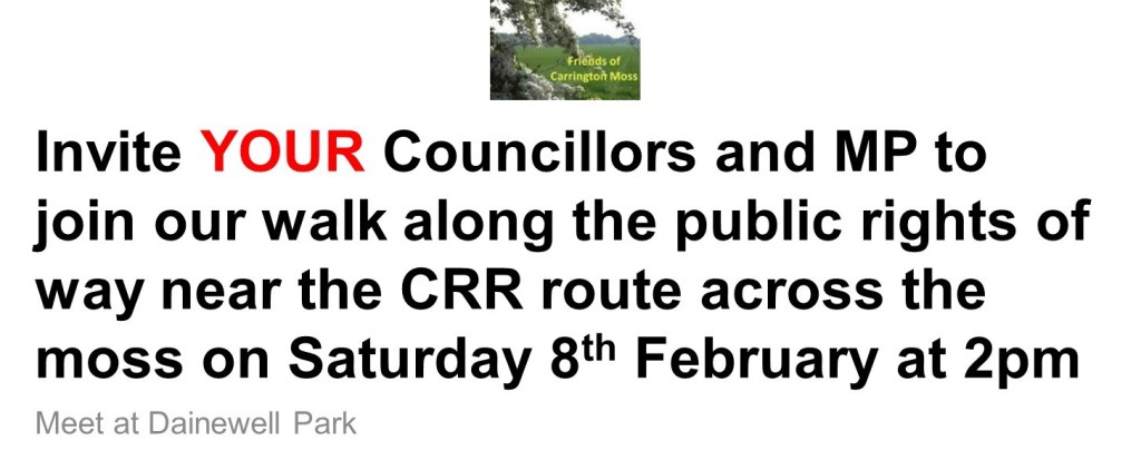
The Friends of Carrington Moss have responded to the Environmental Scoping Report for the Carrington Relief Road. Take a look at the issues we identified in our letter below:

Dear Planning and Development Team

The Friends of Carrington Moss are responding to the EIASCO Scoping report for the Carrington Relief Road (CRR) as there are a number of inconsistencies, errors and concerns in relation to the document.  We set out the most important issues below and in the attachment.

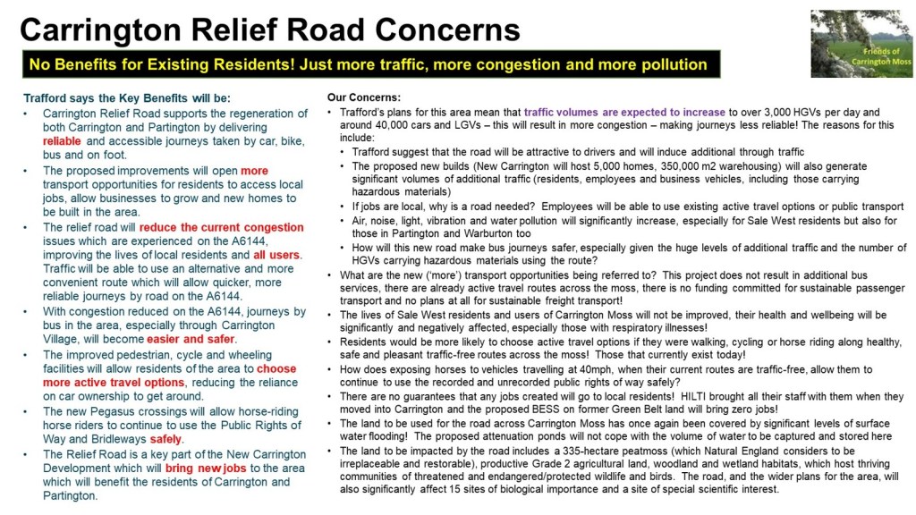
The document confirms that (paragraph 1.2) the key objective of the road “is to provide sufficient capacity within the transport network to deliver growth of housing and employment in the wider New Carrington masterplan area, and realise the socio-economic benefits of the future development”.  Yet, it has been sold to existing residents as a means of addressing their transport and isolation issues – which it will not do for the following reasons:

  • It will significantly increase traffic in the area, as acknowledged within the report
  • It does not provide any relief from the huge and increasing number of HGVs that travel on local roads every single day (along with the consequential air, dust, noise, light, and vibration pollution)
  • It will not bring any benefits to Partington or Sale West residents and whilst it is “intended to take traffic away from the A6144 Carrington Lane and Manchester Road” (paragraph 16.63), the expected significant increase in traffic levels is likely to result in Carrington Village being surrounded by a highly congested road network.

We do not believe these issues will be adequately tested within the Environmental Assessment (based on the contents of this Scoping report).  In addition, whilst the document purports to bring public transport benefits, other than delivering an increasingly congested road surface, the provision of improved public transport services is outside the scope of the scheme (despite paragraph 16.3 suggesting that the “new relief road will provide significant upgrades to public transport”).  An alternative scheme to reopen the former railway lines would bring significantly more benefits to current and future local residents.  We do not agree with the demolition of the Burford Bridge as that will restrict opportunities for rail connectivity to Carrington businesses in the future.

One of the main inconsistencies is that the document repeatedly states that the CRR “will comprise 4.1km of single carriageway road”.  Yet, the report also suggests that part of the road will be dualled.  This will, of course, result in greater land take, higher costs and more congestion (especially for West-bound traffic).

We are concerned that dualling even part of the road will result in inappropriate speeds (drivers tend to exceed the limit, rather than drive more slowly than allowed) and we will object to the proposed 40mph speed limit on the Eastern extent of the road (paragraph 4.38, see also paragraph 14.46).  This will be dangerous for those crossing, especially with horses, dogs or young children and will also lead to more wildlife casualties.

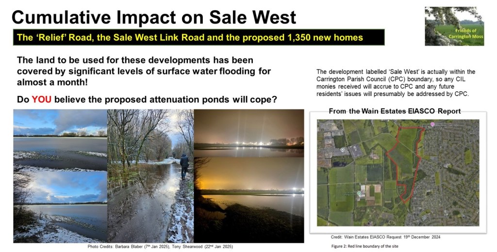
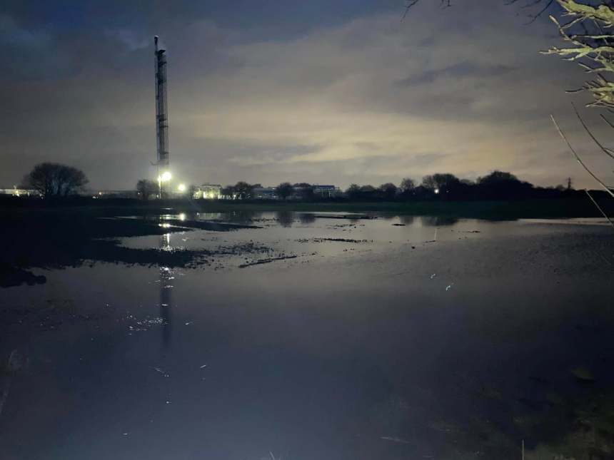
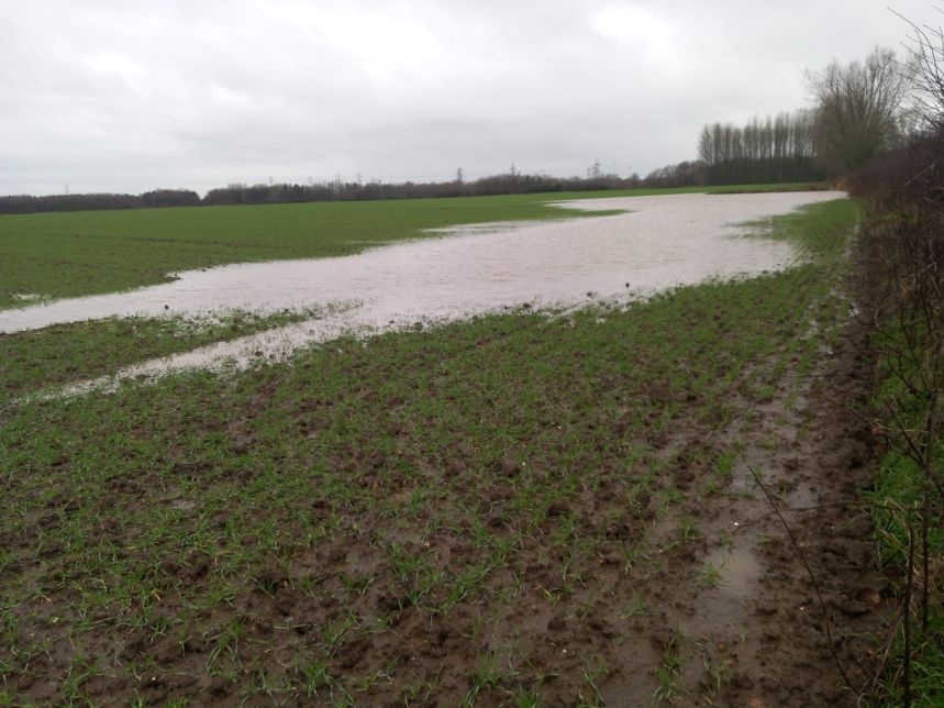
Whilst the document confirms (eg paragraphs 4.138, 9.21) that the CRR route is in Flood Zone 1 (the lowest risk of flooding), we are concerned that the lack of local knowledge underestimates the level of water captured in the area (please see the videos and images on the Carrington Lake page on our website which shows extensive surface water flooding on the site of the road).  According to the document it is intended that all the Attenuation Ponds will discharge into the River Mersey.  We are rather alarmed that this will lead to the potential for the Mersey to breach its banks more frequently than it currently does today.  This will have an impact on local residents and users of the Mile Road in Flixton.

In addition, Natural England suggested (at the Places for Everyone Examination) that there are 335 hectares of restorable peat at Carrington and we do not believe the impact of the proposed hydrological changes on the peat has been fully covered by the EIASCO Scoping exercise.

We will review the comments of the statutory consultees in relation to the issues scoped in and scoped out once they become available and we may have further comments at that time but we would like to highlight that Operational Vibration (paragraph 13.12) should be scoped in, rather than scoped out because of the number and weight of the HGVs that will travel the full length of the CRR (which could have significant adverse effects for the proposed new homes at the Eastern end of the site and the existing businesses at the Western end).

Furthermore, paragraph 16.23 dismisses the impact of the scheme on businesses within Aston upon Mersey but does not consider the productivity implications of the increased traffic and the delays they will be facing both at the Carrington Spur junction and on the Spur itself.

Whilst we appreciate that the document acknowledges (eg paragraphs 10.63 and 10.65) that the construction of the road will have significant effects, we do not believe all the impacts on human and wildlife health have been fully considered.  The Air Quality measures, for example, include locations way beyond the red line boundary (eg TR27, SAIN, TR25) and, as acknowledged in the report, refer to the Covid 19 period.  We are unclear whether the DEFRA modelling anticipates the level of development, especially the huge and increasing numbers of HGVs.  You may already be aware that Carrington Parish Council has installed an Air Quality Monitoring System on Manchester Road opposite the entrance to the business park.  The data from this system should be considered within the Environmental Assessment, along with relevant monitoring locations within the red line boundary.

The document confirms, in relation to Greenhouse Gas emissions, (paragraph 18.10) that “At the time of drafting this scoping report, only preliminary data and background research is available to inform the decisions”.  We would welcome further information as soon as it becomes available.

With all of the above and our attachment below in mind, we would appreciate the opportunity to discuss the road design and intended future actions in detail with the project team.

Kind regards

Marj Powner (Chair)

On behalf of the Friends of Carrington Moss

Summary of Issues and Concerns

Consultation

It is with great disappointment that we note that communities do not feature in this Environmental Scoping exercise in any way, shape or form, despite residents being the key stakeholder and the people with the most knowledge about the area within the red line boundary. 

Section 3 of the Scoping Report does not make it clear that there is a role for communities in the Environmental Scoping exercise (see paragraph 3.4).  This is a huge omission as the Scoping exercise should take into account inputs from (among others), the Parish Councils, the Friends of Carrington Moss, Trafford Wildlife, Peak and Northern Footpaths Society, and the British Horse Society.  We are the organisations with the in-depth knowledge of this site.  There should also be inputs from, for example, of the children with Special Educational Needs who regularly use the PROWs at the Eastern end of the site, between the Carrington Spur and Isherwood Road.

Paragraph 3.13 states that “Engagement with key stakeholders has been regularly undertaken over a number of years”.  This is incorrect.  Communities have only been involved in one very limited engagement exercise and, even then, our inputs were not included in the report to Committee (neither was the Natural England response). 

There is no mention of consultation in relation to the Environmental Scoping (ES) exercise in Sections 7, 8, 9 and 10

Section 11 (Biodiversity) suggests that future consultation for the ES will be carried out only with the GMEU.  Whilst their input is very valuable, the reserves on Carrington Moss are maintained by Trafford Wildlife and are also well known by Cheshire Wildlife Trust.

Section 12 (Socio Economic and Human Health) does mention “other interested parties” (paragraph 12.3) but it is not clear which organisations this refers to.

Sections 13, 14 and 15 suggest future ES consultation will only be carried out with statutory consultees.  Sections 16, 17 and 18 state that no consultation with statutory bodies has been carried out to date and does not mention involvement of communities.

Increasing Traffic Volumes

The document repeatedly highlights the impact of increasing traffic, with many references to the number of HGVs (see, for example, paragraphs 4.46, 4.47, 4.114, 7.5, 7.6, 10.72, 11.57 and 14.46), emphasising that design features will be needed to accommodate increased traffic volumes (including, for example, a signalised junction at the Lyondell Basell compound, along with a dedicated left-hand turning lane, and alterations to the Banky Lane junction to accommodate future traffic demands).  The report suggests that the CRR is planned to “limit the growth of road traffic” to single carriageway capacity (paragraph 7.5).  We do not believe the Environmental Assessment will test that premise (based on this scoping document), especially as that paragraph 11.57 suggests that traffic volume (and air pollution) increase is only a possibility, which is ludicrous given that the purpose of the road is to support extensive development.

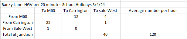
The Friends of Carrington Moss has offered to share the outcome of our traffic counts with the project team to supplement the reliance on other outdated information (paragraph 7.14).  Our counts are up to date, taken by residents, in specific locations on the existing route, at various times (including during term time and school holidays).

Health and Wellbeing of existing residents and wildlife

Section 12 (Socio Economic and Human Health) appears to underestimate and minimise the potential impact of the scheme on existing residents.  We would like to see more emphasis on:

  • Alternative sustainable freight transport – rail and water
  • Alternative sustainable passenger transport – firm commitments to increase the bus services (these have been promised in the 2006 UDP and the 2012 Core Strategy)
  • The health implications of walking, cycling and horse riding next to over 3,000 HGVs a day and thousands of cars – rather than using the current safe, pleasant & healthy routes across Carrington Moss
  • The productivity benefits of green spaces and access to nature
  • The impact of the scheme on the health and populations of wildlife and birds (it seems the plan is to further reduce the already significantly depleted population of skylarks, for example, moving them elsewhere is not the answer)
  • The loss of recreational space and opportunities
  • Schools within the allocation area

There is a recognition that:

  • the prevalence of asthma and COPD in the Study Area is likely to be higher than could be anticipated at a national level” (paragraph 12.80)
  • the “Site LSOAs are within the 6-8th worst performing deciles nationally for air quality, and within the 8-9th worst-performing deciles nationally for sulphur dioxide (SO2) levels” (paragraph 12.95)
  • air pollution in Trafford generally (relating to fine particulate matter) is worse than regional or national levels” (paragraph 12.96)
  • There are significantly more people living with disability within the area surrounding the Site than Trafford generally, or nationally” (paragraph 12.111)
  • There is considered to be significantly higher prevalence of Asthma and COPD in the area surrounding the Site than could be anticipated at national level” (paragraph 12.113)
  • Air quality in the Study Area is considered to be poor, and the Site lies within the Trafford Air Quality Management Area” (paragraph 12.114)

Given the above, we would like more information about the proposed mitigation of the significant health impacts of the scheme.

Inaccuracies and Inconsistencies

It would also be helpful if the report was accurate.  Paragraph 16.6, for example, states that “the Site was traditionally dominated by a long-established Petrochemical works” and paragraph 12.90 states that the “area surrounding the Site is largely industrial in nature, dominated by the Carrington chemical works and power station, and business parks”.  That is incorrect.  These statements refer only to the Western part of the site, which is not contentious.  The Eastern part of the CRR will be constructed on Grade 2 agricultural land.  This part of the site is dominated by fields, woodland and extensive landscape views!  

Paragraph 4.3 suggests that the site “is located close to the SRN including the M60, M62, M6 and M56 Motorways” and paragraph 12.103 describes Stretford & Gorse Hill communities as being “close” to the Site.  What is the definition of close?

Paragraph 11.14 states that “Brookheys Covert is managed by the Cheshire Conservation Trust as a nature reserve”.  Cheshire Conservation Trust hasn’t existed for quite some time – it was a forerunner of Cheshire Wildlife Trust.  Brookheys Covert is owned by the National Trust and the community organisation Trafford Wildlife conducts conservation work on their behalf.

Paragraph 4.25 suggests that “Between the Redline Site Boundary and the A6144 Carrington Lane to the north of the CRR Route is Sale Sharks Rugby Club Training Ground“.  We believe this should say Sale Rugby FC Training Ground.

There is a lot of confusion about Wards, populations and communities, which is why it would be a good idea to involve resident groups in this exercise.  Paragraph 12.61, for example, states that “The Proposed Development is located within Trafford Local Authority Area which had a usual resident population of 10,291 people, according to Census 2021 data”.  Which area does this figure actually relate to?

Similarly, paragraph 16.16 states that “the overall proposal of new Carrington will provide approximately 5,000 new houses across a total area of approximately 179.7 hectares”.  This figure should be checked as the overall allocation area is 1,153 hectares (which will provide both housing and warehousing development), of which Green Belt is 169 hectares.

St Marys Ward is now called Manor Ward (paragraphs 12.24, 12.127).  In terms of Wards “immediately surrounding the Site”, if Davyhulme, Flixton and Urmston are considered to meet this criteria, then Broadheath and Bowdon Wards should also be included.  Paragraph 12.190 mentions Warburton Ward.  Warburton is a village, it is in Bowdon Ward.

Paragraph 12.24 also mentions that, for comparative purposes, Salford City Council and Manchester City Council will be used as a baseline.  On what basis are these Councils comparative to Trafford (they are both urban/City areas with very limited rural locations)?  A more appropriate Council to use would be Tameside (which has a similar land area and a similar population level). 

Paragraph 12.31 suggests that “the most important sectors, by total employment for Trafford is within the Professional, Scientific, and Technical Sectors, followed by business support services, and Retail”.  These are not the sectors being provided by the New Carrington development!  Further information is required about this analysis.

Similarly, paragraph 12.47 states that “there is capacity at Primary and Secondary schools across Trafford” and paragraph 12.51 states that “Trafford have firm plans to deliver 1,330 additional new primary school places on a permanent basis to cater for the additional needs, for the period 2023/24 to 2024/25”.  This is not consistent with our own research and again, we would welcome more information about this analysis.

Paragraph 12.54 does not mention dentists or access to hospitals, which will be key community facilities and paragraph 16.22 does not mention Manchester United or Sale Rugby FC as local businesses.

There is an ironic typo in paragraph 4.4 but of more concern is the inference that the Ship Canal is a beneficial transport corridor (to the Atlantic Gateway).  The alternative of making use of this sustainable transport option has been dismissed in favour of an unsustainable road solution.

Finally, we believe that this document needs a further review to ensure it is as up to date as it should be.  Paragraph 14.6, for example, states that the consultation on the Trafford Local Plan has recently closed.  We do not believe there has been a consultation on the new plan since 2021.  Paragraph 17.8 refers to the Environment Bill 2020, which became law in 2021.

What will be the true cost of the Carrington Relief Road?

Committee member, Lorraine Eagling, reviews the agenda item relating to the plan for the Carrington Relief Road, which was discussed at Trafford’s Scrutiny Committee on 13th March 2024.  A link to the recording (from 47:49 minutes) can be found here and the report is available here.

The new part of the relief road will be constructed across farmland, parallel to the A6144 between Isherwood Road and the Carrington Spur.  In the presentation to the Scrutiny Committee the new road was described as ‘not a big road’ (despite previous suggestions that it would be a dual carriageway).  The main carriageway that carries motor traffic will be 7.3 metres wide and there will be 5 metres on either side for active travel (2.5m for pedestrians and 2.5m for cyclists), so a total of 17.3 metres wide.  

This field, which grew potatoes last year, will be sacrificed for the road and for housing

It is really encouraging to see that pedestrians and cyclists are given so much consideration, but would residents want to walk, let alone cycle beside a major road that carries over 3,000 heavy goods vehicles a day, along with a huge number of cars? 

Would an active travel corridor that runs parallel to the existing road be a better option?  We think it would!

And what about horse riders, we have over 1,000 horses stabled on and around Carrington Moss!  We have repeatedly raised their needs with Trafford and yet they still don’t even get a mention in this presentation!  At least one of the stables provides services to children with special educational needs.  Those children will not be able to ride near to the thousands of motor vehicles that will be travelling along the Carrington Relief Road every day, the noise alone will be an issue.  They currently have lots of options for circular routes along the very safe and very quiet public rights of way, short circuits or longer rides.  The road is going to fracture their routes and reduce the opportunities for these very vulnerable members of our community.

The Scrutiny Committee were given a presentation on the history of New Carrington, which showed that since the closure of the railway line in the 1980’s, Partington and Carrington have become increasingly isolated and car dependant.  Several Councillors raised the question of why sustainable options aren’t being re-introduced like re-opening the old railway bridge to allow for a light rail or full rail link between Irlam and Timperley.  Councillor Holden explained that this idea has been around for some considerable time because a bridge was built in Broadheath so that this train line would remain viable.  We know that former MP, Kate Green, with the backing of the residents of Partington and Carrington, lobbied Parliament about re-opening the line, so it is not new to Government. 

Now that HS2 has been scrapped, shouldn’t this be something the GMCA and Trafford Council actively pursues? Especially when New Carrington is the largest development in the Greater Manchester Spatial Framework (frustratingly, New Carrington is described by executive members as ‘one of the largest brownfield sites in Greater Manchester’, which is highly misleading given the majority of the brownfield land already has planning approval and 169 hectares of greenbelt will be released for the development of housing, warehousing and roads, affecting a 335 hectare peatmoss, Grade 2 agricultural land, woodland and wetland habitats).

Interestingly, Stockport Council, which pulled out of GMCA’s Places for Everyone (PfE) Plan in order to protect its greenbelt, is now in talks with TfGM and GMCA to have the Metrolink extended to their new transport interchange

So, as the largest site in the PfE Plan, why isn’t New Carrington being prioritised for such sustainable transport investment, especially when it is described as the ‘Western Gateway’?

In a recent traffic survey, carried out by Friends of Carrington Moss, during peak times we recorded approximately 50% of the traffic coming from the M60 going towards Carrington and less than 50% of the traffic from Carrington headed towards the M60.  In fact, approximately 50% of the traffic coming from the M60 is headed towards Sale West and over 60% of the traffic from Carrington and Partington headed towards Flixton.  Full details of our survey can be found in my previous blog here.

During term time, peak time traffic increased by approximately 500% and there was significant traffic queuing from the M60 to Sale West and from Sale West to the M60.  There was no queuing traffic in other directions or at other junctions.

In essence, only half of the traffic surveyed used the existing A6144, which the new road aims to relieve!  It is evident that the main cause of congestion is school traffic which could be reduced by reviewing Trafford’s school admissions policy and providing school buses.  Shouldn’t the Council tackle this issue instead of spending £76.5 million on a road that only 50% of existing traffic will use and that will offer no relief to the residents of Partington and Sale West as explained in my previous blog?

At the Scrutiny meeting, Councillors also raised the issue of how the Council will raise in excess of £54 million of public money for the relief road.  The Council’s Director of Growth & Regulatory Services, Adrian Fisher, acknowledged the risks and explained that when the planning committee addressed all of the infrastructure needs of New Carrington, which includes all roads, schools, playing fields etc, they decided that in theory there is enough funding from developers to meet needs.  He explained that the main issue is with the sequencing of the funding, that where the main risks arise is getting the first bit of infrastructure up and running.

Sequencing is definitely an issue, as it’s the chicken or the egg scenario.  Developers’ contributions are based on all development completed, but they won’t develop all sites unless the relief road is built!  Mr Fisher describes the site as the biggest in Greater Manchester and it will not able to deliver houses unless the road is built!

So, at what point will the developers make their contribution?  Trafford have recently had their fingers burnt when it comes to developers Section 106 contribution.  Also, as mentioned in the meeting, the developer contributions are not only for this road, but for other roads that will be needed for this huge site, for schools and other community facilities.  Will the developer contributions be enough for all this infrastructure?  The answer is a definite NO!

Councillor Carter asked how the new road would impact the peat land to the south of the proposed carriageway, in particular relating to drainage.  Mr Fisher acknowledged that there is significant peat in the south part of the site and that this will be an issue when it comes to development in that area and will be an important consideration.

We know how important peat moss is, so much so that the Government is investing in peat restoration to fight climate change.  With this in mind, why would Trafford Council give planning permission to build on this precious habitat?  The answer is that they are wedded to building a road, rather than advancing more sustainable options and, if they don’t give planning permission, they will not get the developers’ contributions towards the costs of the road.

Councillor Holden raised the issue of extensive contamination, and now there is the recent discovery of PFAS (Per-and polyfluoroalkyl substances) on the site.  Mr Fisher acknowledged that this will be addressed when building the new road and this is why the costs of the road has increased significantly.  He explained that a separate drainage system is needed to avoid contamination of groundwater as a result of run off from the road.  It was confirmed that the Council will be working with the land owner/developer and the Environment Agency to come up with a solution that avoids flushing out contaminants into local watercourses and environment.  We know that this area is particularly sensitive for the water environment given its location above a principal aquifer and nearby surface waters including the River Mersey and Sinderland Brook, so it is vital any contamination risks are appropriately remediated.

So, what will the true cost of the Carrington Relief Road be? Not just in financial terms but in relation to the ecology and biodiversity of the area, in relation to the health and wellbeing of residents and in relation to climate mitigation issues that will impact future generations, our children and our grandchildren? 

New Carrington Transport Strategy

Lorraine Eagling looks at what the Strategy means to residents given today’s traffic volumes!

It’s without question that a transport strategy is desperately needed by the residents of Carrington, Partington, Sale West, Warburton and Ashton on Mersey even before the plans for New Carrington get underway, so it was encouraging when Trafford Council published The New Carrington Transport Strategy but very disappointing that no residents had been involved in its development.   

The residents of these isolated and poorly served towns have long been promised and waited for a plan that provides the transport solutions they deserve, that are sustainable and will provide long term options for existing residents and for future generations.

The Strategy describes all the sustainable options (scenario 3) that would provide residents with regular and reliable connectivity to the rest of Manchester.  Solutions that would provide the residents with access to trains and trams and reduce traffic on local roads.   The Strategy goes on to explain, however, that these long-awaited public transport services are not an option because they are too expensive to implement and the only affordable option is a relief road, now expected to cost a minimum of £76.5m (and that is before any resident requirements such as additional junctions, crossings and traffic calming measures, for example are included in the design). Reminiscent of Bullseye’s infamous phrase ‘look at what you could have won!’, residents have once again been let down. 

The proposed relief road will run along the existing A1 Road, which starts opposite the Saica paper factory, to Isherwood Road.  From here a new road will be constructed adjacent to the peat moss and across the farmland to meet the Carrington Spur Road at the junction with Carrington Lane in Sale West.  The new section of the road will have massive implications to the environment. More details about the impact of the CRR can be found at this link, where you can look at our many previous blogs about the Carrington Relief Road by scrolling down the web page.

It’s a very disappointing outcome and it is questionable when the following is taken into consideration:

  • There is no mention of HGV traffic anywhere in the report.  As we know, the huge number of HGVs is the main concern for residents in Carrington Village and beyond.
  • The traffic data used in the report is taken from TfGM 2017 base year, which is outdated and pre-covid.  Considering the implications of this Strategy, the data should be current.  It is not clear whether any actual traffic monitoring has been done at key locations in order to access what road interventions would have the greatest benefit.
  • In addition to the outdated TfGM data, the Strategy interpreted daily travel modes from evidence of what it describes as ‘comparable brownfield’ development sites in South Gloucestershire, including areas of Stoke Gifford, Bradley Stoke, Patchway and Filton, on the northern edge of Bristol.  These sites have their own train stations and are home to industries such as aerospace and hi-tech engineering.  This is hardly comparable to New Carrington, Partington, Warburton and Sale West, where there are no train stations and the main industry is HGV intensive warehousing and logistics.   Also, New Carrington is not just brownfield, it is green belt, comprising peatmoss, woodlands, wetlands and grade 2 agricultural land.

What about the traffic data?

We have been collecting our own traffic data at key junctions in Carrington and Sale West for several years, but to verify the figures in the report, we collected some specific data in February and March 2024.   The results of our survey are as follows:

Cars and Vans

Table 1 shows the average number of cars per hour, during peak times, at the junction of the Carrington Spur and Carrington Lane in Sale West.  The red data was recorded during school term time and the blue data was recorded during school holidays.

As expected, the number of cars increases around this junction during term time.  The data shows during term time there are almost four times as many cars travelling from the M60 to Sale West.  Also, the number of cars travelling from Carrington to Sale West is more than double during term time and the number of cars travelling from Sale West to Carrington is more than tripled.    

On average, a total of 2,728 cars pass through this junction during peak times.   During term time, 48% of the car traffic from the M60 is heading towards Sale West and 43% of the traffic heading towards the M60 is from Sale West.  Additionally, 39% of the traffic from Carrington is heading towards Sale West and 47% of the traffic from Sale West is heading towards Carrington.

Other observations at this junction are:

  • Traffic queuing along the Carrington Spur Road from the M60.
  • Traffic queuing along Carrington Lane towards the M60.
  • Other routes were flowing freely.
  • 2 buses maximum during the survey period.

Table 2 shows the average number of cars per hour during peak times at the junction of the A6144, Flixton Road and Isherwood Road in Carrington.  The red data was recorded during school term time and the blue data was recorded during school holidays.

As expected, car traffic increases during term time, with the exception of those vehicles headed towards Isherwood Road.  During term time the car traffic from Carrington to Flixton increases by almost five times.  62% of the car traffic from Carrington is headed towards Flixton.  It is also interesting to see that 36% of the traffic headed towards the M60 is from Flixton.

Other observations at this junction are:

  • All traffic was flowing and there was no queuing at any junction.
  • Some traffic was travelling at excessive speeds, including HGVs.
  • 3 buses maximum during the survey period.

According to the data in the Transport Strategy, 875 cars travel from Partington and Carrington to Urmston (the report does not mention Flixton) on a daily basis.  We recorded 678 in one hour during one peak time and 282 and hour during non-peak time.  It suggests that the data in the report is an underestimation for traffic moving in this direction.

The data in the transport strategy is not as specific as the data we collected but assuming the traffic from Carrington and Partington heading to ‘Sale West’ and ‘10km inside GM’ is the traffic headed towards M60, then their data suggests there are 10,587 cars per day travelling along the A6144 between Isherwood Road and the Carrington Spur Road.  Our data shows 663 cars during peak time and 502 cars during non-peak time per hour.  Assuming two peak times and 10 hours of non-peak traffic, that is a total of 6,346 cars travelling along this route.  This time, the data in the report seems an over-estimation for cars travelling along this section of the A6144. 

We will repeat our traffic count in the coming months, to test the validity of this result.

HGV Traffic

The data shows that during peak times there are approximately 152 heavy goods vehicles at the Carrington Spur junction and 213 at the Isherwood Road junction per hour.   At non-peak times, there are 208 and 206 respectively.  This suggests that HGV traffic is consistent irrespective of peak or non-peak times and is in excess of 2,000 per day. This figure will increase significantly as the proposed new warehousing is built.

Conclusions

Our data shows that:

  • The A6144 Carrington Lane in Sale West has as much car traffic as the A6144 in the direction of Carrington, as 48% of the traffic from the M60 turns towards Sale West during peak times.
  • The A6144 between Isherwood Road and the Carrington Spur has less car traffic than that suggested in the report.
  • There was no queuing traffic at the junction of the A6144 and Flixton Road during peak time. There was, however, significant queuing on the Carrington Spur and on Carrington Lane.
  • There is a massive increase in car traffic during term time indicating that there is insufficient public transport for students to get to school and a large proportion of students are travelling to schools from either outside the catchment area or from outside the borough.

Considering the findings of this data, how will the relief road reduce the traffic issues highlighted?

The biggest issue for the residents of Carrington Village has always been the large number of heavy goods vehicles that pass their front door every day.  The existing A1 Road could be opened immediately to redirect HGVs away from the village.  This would be a quick win (if the businesses in Carrington are willing to use that road).

Partington is experiencing housing development on a huge scale.  The new developments on Lock Lane, Hall Lane, Oak Road, Heath Farm Lane and the Greyhound will create another 1,291 dwellings.  Despite these developments increasing the number of houses in Partington by 38%, the routes in and out of Partington will remain the same.  Only after the cars and buses have contended with the congestion in Partington itself, can they access the proposed relief road further along the A6144.

For residents in Sale West and Ashton on Mersey to benefit from the proposed relief road to Carrington, they will have to access it from Carrington Lane which is already heavily congested even before the new relief road joins this junction. 

In essence, residents in Carrington Village will only benefit if HGV traffic moves onto the existing A1 Road.  Residents in Partington, Sale West and Ashton on Mersey will have to queue in traffic in their towns before they can access the relief road.  The new relief road, which will cost at least £76 million offers no relief to these residents who will see the population in their area increase significantly as a result of the Places for Everyone Plan.  There will be an additional 2,260 houses in Partington and Warburton, 1,443 in Sale West (in addition to the 263 already with planning permission) and 603 in Carrington Village. 

So how can this Transport Strategy justify such significant expenditure on a road that offers no solution to traffic issues that already exist? 

There are other considerations here too: 

  • Why hasn’t the A1 Road already been opened to HGV traffic to resolve the issues in Carrington Village? 
  • Why are so many students being driven to school? 
  • Do the school admissions policies in Trafford need reforming?
  • Does the Education authority or TfGM need to look at providing school buses? 

The data shows that it is school traffic and heavy goods vehicles that create the congestion along the A6144.   These are the issues that need addressing rather than spending £76 million on a scheme that will not solve the transport issues that have plagued this area for decades.  This money could contribute towards the ‘scenario 3’ solution in the Transport Strategy and should be invested in long term, sustainable passenger and freight transport interventions. 

There are several options that could be considered, such as:

  • opening the railway bridge between Irlam and Partington to give residents access to trains
  • opening up the ‘greenway’ and the former railway line from Partington to Altrincham to give residents access to trams
  • revisiting the 2012 Local Plan option to build a bridge from Carrington to Port Salford. 

These are long term sustainable options that will reduce congestion and open up Greater Manchester and the rest of the UK to residents of these local areas.

What we need is a Transport Strategy that meets residents’ requirements, why isn’t Trafford talking to us about it?

Does the New Carrington Outline Transport Strategy address resident priorities?

We had hoped the collaborative way the New Carrington Masterplan is being managed would prevail for other aspects of development in the area, but sadly, no!  Once again, we have a “strategy” that has been agreed by Trafford’s Executive without any input from the residents who will be severely impacted by its implementation (not only by what is in the “strategy” but also by what is not)!

At a recent Trafford Executive Committee meeting (29th January 2024), the report about Infrastructure and Development in New Carrington was introduced (we note there is a typo in the report date but it was presented in 2024, not 2023).  As part of this report the New Carrington Outline Transport Strategy was presented to the Executive.

On the positive side, the Council has begun an open and transparent process for developing the Masterplan for New Carrington (the details are on their website here).  This is good news, because, it is clear that residents have a lot to bring to the table in relation to what is needed in the area.

The Executive report itself is actually a marked improvement on previous documents created by Trafford about the Carrington Relief Road.  It does acknowledge some of the issues that have arisen (and continue to be identified).  In view of Trafford’s declaration of a climate emergency back in 2018 and its carbon neutral goals, set out in 2020, the accompanying Transport Strategy document, however, remains unambitious and has several major omissions.

Interestingly, that “strategy” document was produced in September 2023 but has been kept under wraps until after the Places for Everyone (P4E) Modifications Consultation was completed, which is rather disingenuous of Trafford’s politicians and officers, given that its contents signal concerns about whether the huge list of “Necessary Transport Interventions” set out at Appendix D (page 708) of the P4E Plan can, or will, be delivered. 

Resident Priorities?

Whilst the production of this “strategy” is to be welcomed, there has been no involvement of the community in determining the Vision, or the aspirations, and there is nothing in the document that suggests that communities will be engaged as the “strategy” evolves in the future!  It is, therefore, not a surprise that it merely continues to promote car/HGV-dependency, leaving a legacy of huge levels of air, noise, light, vibration and water pollution (to say nothing of the carbon emissions), that will result in poorer health outcomes for residents and higher costs to the public purse.  There is a reference to a specific consultation about one initiative, the Carrington Relief Road, but that was supposed to commence in January 2024, so is already behind schedule.

HGV traffic on the A6144 is, by far, the biggest concern for residents, yet there are no figures in this document which identify the size of the issue (either now or in the future), nor does it explain how Trafford proposes to address this problem.  The “strategy” confirms that the new road will be the panacea for freight transport!  Yet, we know that businesses are not in favour of restricting HGV use on the A6144, as was confirmed in a response to a planning application.  There is no indication about how the proposed route changes will be agreed with businesses and implemented so that travel through Carrington Village can be limited to local resident movements.

So, what we have now is a “strategy” which:

  • does not address any of the issues related to the huge number of HGVs that are travelling on local roads, there are no references to sustainable freight transport solutions and no aspirations to even consider them – is this really a strategic document?
  • does not estimate the anticipated induced traffic that will arise from the construction of the proposed new roads (causing more congestion, much higher levels of pollution and increased travel incidents), particularly for Partington, nor does it reveal the ultimate aim, set out in the GM Transport Strategy 2040, to create a link between the M60 and the M62 via Carrington (page 124/125), which will undoubtedly induce immense volumes of motor vehicle traffic through the area
  • does not even mention the importance of local travel routes to horse riders (there are more 1,000 horses stabled in and around the area – source British Horse Society) – this is a huge gap as horse riders need specific surfaces (to reduce the potential for the animals to slip in wet weather, for example, and specific crossing points) – it would be inappropriate to consider active travel routes here without including their considerations.

The background facts are rather selective, there is no reference, for example, noting that Partington has a much lower rate of car ownership (27.2% of households with no cars or vans according to Census 2021) compared to the rest of Trafford (19.3%).  Neither is there any mention of the likely changes arising from the increased charges on the Warburton Toll Bridge.  There are no figures highlighting the difference in traffic volumes during school term times and school holidays (there is a marked variation in numbers which we have observed in our traffic counts that could be addressed through increased school bus services, cycling buses and other initiatives).

Because the proposed new road will be constructed adjacent to and beyond Carrington, it is more likely to induce additional traffic into Partington than to relieve traffic for residents there.  Other initiatives are needed to improve transport options for Partington residents, such as community transport and the reopening of the former railway line between Timperley and Irlam.  This latter scheme would be highly beneficial to the people of Partington and would enable sustainable passenger and freight transport to be fully examined.  Given the lack of consideration for this option from Trafford, Partington Parish Council has begun to explore opportunities to raise the funding needed for a feasibility study for the initiative.

What about the funding?

There is very little information in the document about the costs/funding of the overall “strategy”.  There are only figures related to the Carrington Relief Road (£76.5m) and the overall Greater Manchester Transport Strategy 2040 (£1.1b).  Our own very conservative estimate puts the overall cost of the “Necessary Transport Interventions” for the New Carrington development to be over £400m, see Appendix D (page 708) and listed in the graphic above. 

That GM Transport Strategy 2040 aims to reduce car use to no more than 50% of daily trips by 2040 and reduce demand on road space from freight, moving freight traffic onto rail and water-based transport by the same date. The associated Transport Delivery Plan states that “The Right-Mix aim is for 50% of trips to be made by sustainable modes across GM.  This will require zero net growth in motor vehicle traffic between 2017 and 2040, and non-car mode share to increase from 39% of all trips in 2017 to 50% of trips in 2040”.

With the strategic aim to significantly reduce motor vehicle traffic by 2040 (just 16 years away) in mind, along with the requirement for zero net growth in motor vehicle traffic, there is surely no business case for public money to be invested in a new road, that will impact the borough’s and the region’s carbon neutral ambitions, and generate huge levels of air, noise, light, vibration and water pollution.

Given the very marginal viability of the allocation, especially taking into consideration the contamination issues raised at the Executive Committee meeting, we believe that the public purse will be required to pick up the vast majority of these funding requirements and/or local residents will be forced to accept a huge development without the benefit of the Necessary Transport Interventions to make it, not only sustainable, but also tolerable. 

The Committee Report particularly highlights (paragraph 5.9) the long-elapsed time of the funding period for the Carrington Relief Road (a 9-year funding programme).  Consideration should be given to alternative options that may reduce the cost impact for the public purse and make sustainable transport solutions a reality.  This could include upgrading the existing routes (A6144 and the A1 currently private road in Carrington), along with significant enhancements to the public rights of way across Carrington Moss, making them suitable for extensive active travel, horse riding and, possibly, bus services only.  This would be a much more attractive option for encouraging modal shift as walking and cycling next to huge numbers of HGVs and other motor vehicle traffic is unpleasant, unhealthy and unsafe.

At the Executive Committee meeting a number of insightful questions were raised by Councillors, including Councillor Welton, who asked why there is no analysis of the costs of not achieving Scenario 3 (which is the most sustainable option).  As Councillor Welton highlighted, not achieving that scenario will lead to higher costs in terms of carbon emissions, poorer public health outcomes, increased traffic incidents and congestion and higher costs of road maintenance. 

More Missing information – Carbon Emissions!

The Transport Strategy does not include any information about the carbon implications.  There are no calculations that estimate what impact the different scenarios could have on Trafford’s carbon neutral ambitions. 

Interestingly, the “strategy” references the Greater Cambridge Local Plan to support its assertions in relation to compable sites.  In the P4E assessment work we have done with partner organisations, including Steady State Manchester (who produced an excellent document which calculates the carbon emissions resulting from P4E), our responses to the Planning Inspectors included reference to the Greater Cambridge Local Plan.  Their plan, unlike P4E, incorporated a Strategic Environmental Assessment that calculated the projected carbon emissions for each spatial option being considered (and they were comparable to the spatial options set out in P4E).  Cambridge discovered that coupling residential development and public transport leads to approximately 20% lower carbon emissions than a strategy that promotes car-dependent development in the Green Belt!

Given Trafford’s climate emergency declaration and carbon neutral ambitions, the document should be very clear how such a large development, and the associated road infrastructure, will impact both Trafford’s and the region’s carbon neutral goals.  The lack of sustainable freight transport options is a key consideration here because the carbon implications of the huge numbers of HGVs will be significant.

Comparing New Carrington with similar areas?

The “comparable” areas mentioned in the document are not actually analogous with New Carrington.  The benchmark sites (such as Filton, which has the UK’s largest Aerospace Area – BAE Systems, Rolls Royce, Airbus to name a few) are home to a Global Technology Centre and companies such as Filton Systems, Hewlett Packard and Viridor.  These industries are not like those businesses that are currently operating in (or are proposed for) New Carrington, which are predominantly warehousing/logistics units that generate extremely high numbers of HGV journeys.

Additionally, Filton and the surrounding areas of Stoke Gifford, and Patchway each have their own train station, whereas Carrington, Partington, Sale West and Warburton have no train stations and non are proposed in this “strategy”.  Another “comparable” site, Waterbeach, is a new development but, unlike New Carrington, it is getting its own train station.  There are no large warehousing sites proposed for that location.  It will have flexible workspaces and hubs (more cottage industry makers and creators) and, therefore, limited HGV traffic!  It is a real challenge to understand how these sites can be considered to be “comparable” to the New Carrington location!

The Executive Report states (paragraph 9.1) that “New Carrington will be the main growth point in Trafford for the next decade or more” but the New Carrington allocation is not even comparable to Trafford’s other major warehousing location – Trafford Park does have sustainable freight transport solutions!

What about the deep peat deposits on Carrington Moss?

At the P4E Examination in Public, Natural England’s contributions included the following:

  • Natural England (NE) wrote to the planning inspectors in June 2023 (OD42), stating that there is extensive and restorable deep peat within allocation JPA33 (New Carrington), that the deep peat should be considered to be an irreplaceable habitat, and that “the combination of the location and the extent of development proposed by the allocation policy means the proposed development is incompatible with avoiding the deterioration of this irreplaceable habitat
  • NE’s view, set out in OD23, is that the development will not only prevent future restoration but “will cause irreversible damage to the body of peat directly under the developed land and the wider peat mass, which depends on the continuity of the flow of water”.  They go on to recognise that the degradation of the peat mass will also result in significant greenhouse gas emissions
  • NE confirmed (in OD42) that their position is in line with the England Peat Action Plan, that there should be no development on (restorable) deep peat, and that peat should be kept wet and in the ground.  NE drew attention to their “extensive experience of peatland restoration projects” which provides considerable credibility to their professional judgement in this matter.

So, for Trafford to conclude in the report (paragraph 7.7) that “peat is not considered to be a significant constraint on future infrastructure provision” demonstrates a huge lack of understanding of the impact of hydrology on the main body of peat, which Natural England estimates to be around 335 hectares.  This is not a surprise, as it is recognised that Natural England are the experts, not Trafford, and their advice should be followed.

Even More Omissions from the “Strategy”!

Whilst the 29th January Executive Committee report mentions that the 2006 Unitary Development Plan (UDP) included a safeguarded route for the road and that the 2012 Core Strategy significantly underestimated the cost of such a route, it does not explain why the land that was safeguarded for the Manchester Ship Canal bridge is not included in the Transport Strategy.  This was also a Proposal E15 requirement in the 2006 UDP and one of the Implementation Projects listed in the 2012 Core Strategy (p80).  This initiative would reduce the number of HGVs (and other vehicles) on local roads significantly.  It is clear that the majority of the actions set out in previous local plans have not been delivered in this area and the potential benefits of the most sustainable solutions, particularly for freight, (such as bringing the former railway line back into use and/or transporting goods via the Manchester Ship Canal) have been totally ignored by Trafford for almost two decades.

The Carrington Relief Road appears to be going through a name change to the A1 Link Road.  The recognition that this road will not “relieve” anyone is welcome but we do wonder where the road will link from and to!  The government’s announcement about the funding to be made available as a result of cancelling HS2:states that “more than £500 million in funding will be provided for 2 major road schemes around Manchester. These include a new link road between the M62 and the M60Whilst this initiative is set out in the Greater Manchester 2040 Transport Delivery Plan, and we assume the A1 link road is ultimately being proposed to provide the first stage of this scheme, the “strategy” makes no mention of this longer-term proposal.

More information:

There are many tables full of confusing information throughout the document.  The calculations about the number of trips do not include the current traffic numbers, the HGV movements and there is no estimate about the expected level of induced traffic.  So, effectively, there is no assessment of the expected overall traffic levels on the new road. 

The “strategy” states (page 18) that “Employment provision in the area should offer a wide range of employment types” and (page 15) that currently 6% of car journeys and 7% of public transport journeys are internal (within Carrington and Partington).  This suggests few residents currently work in the Carrington area, an assertion borne out by our own research.  The current and proposed employment development does not offer a diverse range of job opportunities (despite the assumption on page 38).  It is predominantly warehousing which requires a small, low paid workforce.  There should be more evidence to show how the target of 17% of internal journeys can be achieved.

The current conditions (set out on page 14) focus on Carrington and Partington, without referencing the issues related to Sale West or Warburton, which will be impacted significantly by this “strategy” and, as mentioned above, totally omits any reference to the huge number of HGV movements in the area.

What next?

We have requested a meeting with Trafford to discuss the contents of the “strategy” further and will provide an update to residents as soon as we are clearer about the implications.

Trafford has a website page dedicated to the Carrington Relief Road, you can access it here.

You can find our previous blogs about the Carrington Relief Road by scrolling down at this link.

Is the New Carrington Allocation Aligned with Trafford’s Corporate Plan Priorities?

At a recent Trafford Executive Committee meeting (11th December 2023), the leader of the Council introduced their report about performance against the Council’s Corporate Plan, 2023/24.

On the positive side, the Council has a wide range of responsibilities and there are areas for which Officers and Elected Members should be congratulated but ………..

the report highlights (paragraph 1.6) that

The priorities for 2021-2024 are described as ‘better health, better jobs, greener future’ as outlined below:

Reducing Health Inequalities
Working with people, communities and partners, particularly in deprived areas, to improve the physical and mental health of our residents.

Supporting people out of poverty
Tackling the root causes to prevent people from falling into poverty and raising people out of it.

Addressing our Climate Crisis
Leading the way in our region’s response, reducing our carbon footprint and tackling the impact of climate change”.

Reducing Health Inequalities:

Carrington Moss currently provides deprived communities with a huge area of free to access green space, which will no longer be available due to the proposed development of 5,000 homes, 350,000 m2 warehousing and the plans for 4 major new roads. The moss currently has:

  • almost no traffic, so no air, noise, light, vibration or water pollution – fresh air to breathe (for both humans and wildlife), a peaceful environment for those with anxieties or other wellbeing issues, an area where you can hear and see red listed birds and other endangered wildlife, encouraging outdoor activities and hobbies that improve the health of local people
  • local residents participate in a number of sporting and recreational activities on Carrington Moss, including those professional athletes and children attending the Manchester United or Sale Rugby training grounds, the horse riders who use many of the circular routes (there are over 1,000 horses stabled on or around the moss) and the walkers, cyclists, bird watchers, nature spotters, photographers, artists ….  the list goes on!

Supporting people out of poverty:

  • in the plans for the area, there is only one transport option being funded and prioritised – and that is a new road!  So, those in transport poverty (and there are many in the local area who cannot afford to run a car) will have no benefits from this allocation (Trafford itself describes the area as currently having poor public transport provision)
  • furthermore, the only job opportunities being provided by the allocation are warehousing, which is very limiting in terms of both career choices and wages
  • and those currently working in the rural economy in the area (and their supply chains) will have their job or volunteer opportunities decimated or eliminated entirely!

Addressing the Climate Crisis:

  • the current habitats on Carrington Moss are essential to support the mitigation of climate change and the achievement of Trafford (and the region’s) carbon neutral ambition
  • these habitats include the 335 hectares of peat moss itself (which can be restored to capture and store huge volumes of carbon), Grade 2 agricultural land (which is perfect for growing crops to support the food security of current and future generations), large areas of woodland (which again are a great carbon store and provide shelter and food for the red listed birds and endangered wildlife) and wetlands (which capture and store huge volumes of surface water, that will have to be directed elsewhere when the area is concreted over
  • there are also a number of sites of biological importance and sites of special scientific interest on and around Carrington Moss, these are extremely important for conservation and nature’s recovery.

In addition to all of these benefits, Carrington Moss also has fantastic historical value.  Obviously, the peat has been forming for thousands of years, horses have been ridden over the moss since medieval times, the Victorians used it for dumping night soil and waste (the remnants of the train tracks remain) and, in the Second World War, it was used as a decoy bombing site to save the centre of Manchester.  As typical flat peatland terrain, it also boasts expansive views (you can see the hills over 20 miles away on a clear day).  Imagine the future, with those views changed to HGVs thundering down the planned new road and 22m warehouses blotting out everything else in the landscape!

Paragraph 1.9 of the Council’s report confirms that a “new Corporate Plan is expected for July 2024”.  Given the Places for Everyone Plan significantly reduces the protections brought in by the 2012 Core Strategy, ignores the advice of Natural England and unnecessarily decimates the largest natural capital asset in Trafford, can we expect a similar weakening of Trafford’s future corporate plan priorities? 

PS The Greater Manchester Combined Authority has published the responses to the Places For Everyone modifications consultation, our friends at Steady State Manchester have included the link in their short blog, available here.

PPS The Friends of Carrington Moss are working with other Greater Manchester groups to determine the next steps in our campaign to prioritise brownfield development across the region (and let’s face it, there is a lot of brownfield land that could be used, and GM has received significant public funding to regenerate it)!  We’ll keep you updated as more information becomes available.

« Older Entries Recent Entries »