Not current or new local communities in the surrounding areas, who will suffer from significantly increased traffic, more congestion and the health consequences of air, noise, light, vibration, dust and water pollution, many homes will also be at a considerable risk of flooding
Not horse riders, walkers or cyclists who frequently use the traffic-free routes on, across and around Carrington Moss, whose current safe, healthy and very pleasant trips will be fractured by huge volumes of traffic, they will be required to walk or ride alongside hundreds of highly polluting vehicles, travelling at speed, which will be unsafe, unhealthy and very unpleasant
Not the red listed birds or the endangered wildlife species that breed and feed on Carrington Moss, their homes will be destroyed, their foraging corridors shattered, their lives at risk as victims of roadkill
Government data makes it clear that there are many households in the area which do not have access to a car. Building a new road will not benefit them at all (but they will still suffer the health consequences of increased pollution that are caused by others driving through their areas).
Over the past almost 10 years, despite confirming that this area is poorly served by public transport, Trafford has been unwilling to explore more sustainable alternatives, such as those proposed by the Friends of Carrington Moss.
We hope you will support our campaign to remove the Eastern part of the Carrington Relief Road (CRR) from the plans. This will bring numerous benefits to local communities and users of the moss and will reduce the costs to the public purse.
The submission of a planning application for the road is expected before Christmas. Once it has been validated by Trafford’s planning team, the documents will be made public, and the Friends of Carrington Moss will review them over the following couple of weeks. We’ll share our findings on social media, in our newsletter and at our online public meeting.
In the meantime, please follow, like and share our posts on social media and don’t hesitate to send any comments you may have to friendsofcarringtonmoss@gmail.com.
What is it? What are the key issues? and Why is it important for residents to respond?
As you know, the proposed developments on and around Carrington Moss are huge! 5,000 houses, 350,000m2 employment space and 4 major new roads, all threatening the 335 hectare peat moss (restorable irreplaceable habitat), the productive Grade 2 agricultural land, the woodlands and the wetlands, and all impacting 15 sites of biological importance and a site of special scientific interest, to say nothing of the populations of numerous red listed birds and endangered wildlife species.
Because of the size and scale of the proposed schemes, in addition to the typical costs that would be incurred when they put forward a planning application, developers will be required to contribute to the strategic requirements (such as roads, buildings to support education and healthcare, and utilities), which Trafford describes as ‘hard’ infrastructure. These costs would not have been required had the development been focused on previously developed (brownfield) land, rather than on former Green Belt and greenfield land in an isolated, unsustainable location.
The consultation documentation aims to set out the proportionate financial contributions for schemes that have not yet secured planning permission.
The strategy focuses on those so called ‘hard’ infrastructure items and supposedly prioritises the delivery of New Carrington “in a comprehensive and coordinated manner”. The document confirms (figure 19) that almost half of the identified ‘hard’ infrastructure costs will be funded from developer contributions, and the other half will be funded by the public sector and other sources.
Balanced? Sadly not!
Developer contributions are limited by government guidance. This means that, for a scheme to be considered viable, developers must achieve a certain level of profit. The contributions developers pay cannot be increased to the extent that the scheme would be considered unviable (ie they do not make the necessary level of profit). So, if there are any excluded or missing costs not incorporated within the calculations (and there are a lot of them), the proportions shown in the graphic above are very misleading.
The total contributions to be paid by the public sector should be explicitly and transparently shown, rather than covertly hidden in an appendix or not included at all! It is vital that communities understand the full cost of destroying our essential natural resources to facilitate building in such an unsustainable location.
The biggest issue is the lack of consideration of harms to, or destruction of, natural capital assets.
Given the extensive environmental and ecological harm/destruction to be caused as a consequence of Trafford choosing this location for development, the calculations should include the costs related to the mitigation of, or compensation for, the loss of Green Belt, the cumulative harm to natural capital assets (such as, for example, the peat moss, the woodlands, and the farmland). These have been explicitly excluded from the costs and subordinated to a future phase of the masterplanning work.
This means that the information provided in the documentation is incomplete and does not reflect the actual costs to be incurred if all the proposed developments go ahead.
Effectively, in omitting what we are calling the ‘Natural Infrastructure’ strategy from these calculations, the harms can be caused but funding may NEVER be available to provide the obligatory mitigation and compensation.
Why are we concerned?
Take a look at our response (here), but, in summary, not only have the natural infrastructure requirements been shelved to some point in the future, but our suggested amendments to the proposals have been summarily dismissed, resulting in unnecessarily inflated costs for the public purse.
The cost of the road schemes, for example, would be significantly reduced if our alternative proposals were accepted.
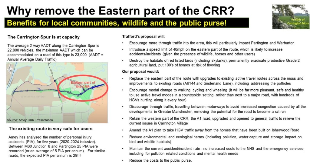
The eastern part of the Carrington Relief Road (CRR), across the moss, could be replaced with upgrades to existing active travel routes and improvements to existing roads (A6144 and Sinderland Lane). This would encourage modal change to walking, cycling and wheeling (it will be far more pleasant, safe and healthy to use active travel modes in a countryside setting, rather than next to a major road, with hundreds of HGVs hurtling along it every hour). It would also discourage the huge levels of induced traffic that will use this road, travelling between motorways and significantly impacting Partington and Warburton. The western part of the CRR, the A1 road, should be upgraded and opened to general traffic as planned to relieve the current issues in Carrington Village. The plan for the A1 should be amended to take HGV traffic away from the homes that have been built on Isherwood Road. This would require a very short road to run in parallel with Isherwood Road/Ackers Lane, rather than a new road all the way to the Carrington Spur.
The latest information received from the CRR team[1] shows that the current road (A6144) is much safer than an average road of the same type and that there is ZERO capacity to increase traffic on the Carrington Spur. Trafford should, therefore, not be proposing a new road that will allow traffic to travel at much higher speeds (particularly given the hazardous materials carried by some of the HGVs), or encourage more through traffic into the area.
Because it includes the eastern part of the road, the current CRR proposal unnecessarily inflates the cost of construction and ongoing maintenance (including for the attenuation ponds needed to capture all that water[2] currently stored on the moss), and the costs of the mitigation needed to address air, noise, light, vibration, dust and water pollution, along with other environmental enhancements. Costs will also increase for the NHS and other emergency services because of increased pollution and traffic accidents/incidents, and there is likely to be an upsurge in the requirement for mental health services due to the stresses caused to local residents because of construction, congestion, the loss of green spaces, and, possibly, future flooding!
Facilitating vehicle access onto Firsway from the new Sale West developments (1,500 homes) will significantly increase traffic and will result in that road becoming a rat run from the M60. It will require the felling of hundreds of trees, drastically affecting the wildlife and birds and impacting the dark skies in this area. It will also increase safety concerns on Firsway and, consequentially, the costs to the NHS/emergency services of dealing with any resulting pollution related health conditions and accidents/incidents on the road network. Limiting access through the Firs Plantation to active travel users only, would not only reduce the costs of constructing the Sale West Link Road, it would also reduce the cost of mitigating or compensating for environmental/ecological harms and the costs to the NHS.
For all the same reasons, we suggested that the Eastern and Southern Link Roads should not connect with each other, as this will result in huge levels of increased through traffic from the M60 and other motorways, particularly impacting Warburton. The proposed approach will also cause extensive damage to the very deep peat that will need to be compensated for. As with the other schemes, it will also significantly increase pollution and will impact the dark skies in this area, with consequential costs for the NHS and other agencies.
All the current proposals for these roads result in the need for higher contributions from the public purse, whilst our alternative options reduce the cost of constructing, the cost of mitigation/compensation for environmental/ ecological harms and the consequential costs to the healthcare sector and the emergency services.
The Healthcare costs included in the calculations seems to be limited to primary healthcare (which comprises doctors, dentists, pharmacists, and opticians), not mental health provision, not hospital provision (known as secondary healthcare) and not other emergency service provision. All of which will significantly increase as a result of the proposed developments. Furthermore, the Council does not recognise the impact on the need for increased social infrastructure because of the employment development (our objection to this is explained in our response).
Sustainable Development
The documentation repeatedly suggests that the ‘hard’ infrastructure is of the utmost importance to the sustainable delivery of New Carrington. Yet, given the definition of sustainable development this is hugely misleading.
The government’s National Planning Policy Framework (known as the NPPF[3]) defines sustainable development as “meeting the needs of the present without compromising the ability of future generations to meet their own needs”.
Given the proposed harms to, or destruction of, irreplaceable habitat, food producing cropland, woodland and wetland, it seems ‘sustainable development’ has a much narrower definition in this suite of documents.
With that definition in mind, it is clear that the New Carrington allocation cannot be ‘sustainable’, even with the proposed ‘hard’ infrastructure investment, because development here is dependent on considerable harm to, or the complete loss of, a number of essential natural capital assets that future generations will not be able to reverse.
And, what is worse, as mentioned above, the costs of mitigating and/or compensating for those cumulative harms is not even included in the calculations set out in this consultation and no information has been provided about how such funding requirements will be addressed, or when!
We would encourage you all to respond to the consultation. You do not have to go into the detail we have in our response, but it is important that the community voice is heard, particularly given that there will be future consultations related to the masterplan. Send your feedback to newcarrington.masterplan@trafford.gov.uk
What should you be asking for (in your own words)?
The masterplan project priorities should be reviewed to ensure that there is a comprehensive understanding of the costs of all elements of these proposals. The Natural Infrastructure Strategy should be considered a prerequisite to finalising the contributions scheme. It should be progressed with urgency, with its evolution including extensive engagement with communities. The land to be used for environmental and ecological mitigation or compensation should also be identified as a matter of urgency.
The documentation provided in this consultation should be updated and implemented when the full costs of the impact of development are known.
No environmental or ecological harms/destruction should be allowed to be caused until it is confirmed that funding for the mitigation and compensation for the loss of Green Belt and those extensive cumulative harms to the environment and ecology will become available. We also need confirmation of where any agreed mitigation or compensation will be located – it is possible that, because of the size and scale of the developments proposed here, enhancements will be implemented elsewhere, which means our local communities suffer all the health, wellbeing and traffic consequences of these plans, and others will benefit from environmental and ecological improvements in their areas!
There has been lots of commentary about Stockport’s withdrawal from the Greater Manchester Spatial Plan (Places for Everyone, or PfE) since they made the decision in 2020, especially about the consequential risk that being out of the plan will lead to more Green Belt release and speculative development. The same threats are being made to those who, more recently, want to remove Oldham from PfE, with some Councillors suggesting the arguments in favour of withdrawal are misleading residents and that this approach “would lead to further developments on the greenbelt”.
Breaking News!
It doesn’t matter whether you are in or out of PfE that risk is still there. Trafford’s rejection of a Battery Energy Storage System (BESS) on retained Green Belt has been approved on appeal by the Planning Inspectorate, despite participation in PfE that supposedly gave protection to that land!
Given the £millions of public money spent on Places for Everyone over the more than 10 years it took to bring the plan to fruition, why hasn’t the media picked up on this issue and who is auditing this failure to achieve even the basic aims of the plan?
Places for Everyone is supposed to be a brownfield first plan, it is supposed to protect retained Green Belt from development, it is supposed to help resolve the housing crisis in Greater Manchester.
It does none of those things!
Green Belt allocations are coming forward across the region (much reported in local press and the MEN) and are being approved in advance of all the swathes of brownfield land available for development (despite huge amounts of public money being made available to regenerate that previously developed land).
Retained Green Belt is not protected by participation in the PfE plan. In the particular case mentioned above, the Planning Inspector used the Government’s ‘Grey Belt’ rules to assert that it is appropriate development. There were no concerns raised about the number of fires that have occurred on such developments, including the BESS fire in Liverpool that burned for 59 hours, or more recent fires in Essex and Aberdeen. At least there will be plenty of water available from the River Mersey should a fire break out, but All Saints Catholic Primary school is just down-wind of the site, so alarms should be raised to alert the school and local residents if a fire or the associated toxic fumes are released. Nothing was mentioned about this by the Planning Inspectorate, which seems to be blindly allowing as much development as possible to support the Government’s war on nature and communities.
There are many ways to resolve the housing crisis, none of which require the release of Green Belt. These are outlined in the Community Planning Alliance Homes for Everyone Report.
The Government and Greater Manchester’s leadership are explicitly ignoring the data that shows:
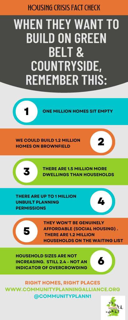
There is sufficient brownfield land available to deliver at least 1.2m homes nationwide
There are 1.55m empty homes across England and Wales (including 70,000 homes owned by councils and housing associations)
There are an estimated 165,000 empty commercial properties that could be turned into houses and/or flats
More innovative solutions could also be looked at, such as promoting the 26m empty bedrooms in the UK that could provide income for the householder and a place to live for someone on a waiting list.
Shockingly, there are many sites which have been granted planning permission but have not been developed that could provide over 1m new homes – yet there is no impetus from the Government to ensure these sites are brought forward BEFORE any Green Belt is released.
Finally, the biggest issue with the housing crisis is the lack of genuinely affordable homes (social or Council housing). This is an issue that has been disregarded for many years and the current Government has not even set a target to ensure Councils increase the number of these homes to address the huge and growing waiting lists. Places for Everyone should have been renamed ‘Places for those who can afford to buy’ because the target for all affordable housing was removed from policy during the modifications process and the target for social housing was removed from the plan altogether!
We have frequently highlighted the impact on nature’s recovery, climate mitigation and our future food security when Places for Everyone was adopted by the Greater Manchester leadership in March 2024. The consequence of the loss of environmentally and ecologically rich Green Belt land which provides all these benefits, along with the other issues set out above, shows the extent of the betrayal of future generations that is now becoming increasingly obvious.
The Planning and Infrastructure Bill (published by the Government on 11th March 2025) intensifies the Government’s war on nature and communities by reducing democracy and weakening protections for flora and fauna. It introduces Spatial Development Strategies, similar to Places for Everyone, but without the consultation previously required. We’ll say more about this in a future blog, but it appears to be yet another Developer’s Charter, as someone else succinctly put it – another Government initiative providing
As the first Carrington Relief Road (CRR) consultation goes live today (20th January 2025), we are issuing our first Call for Action to local communities. Please take the time to respond and encourage friends and family to participate too.
The consultation period includes some face-to-face sessions, and we hope you will be able to attend one of these. Just a reminder that the current CRR team are NOT responsible for the decisions made in the past and that they have been directed to give a very limited scope to the consultation, which is only based on the design of the road!
The inadequacies of this consultation have been determined by Trafford Council, and they have repeatedly rejected our requests for communities to be able to influence the wider aspects of transport solutions for the area – our next Call for Action will address this failure (see below).
This consultation ends on 28th February. Your inputs are extremely important, so do click on this link to read Trafford’s materials and submit your own response. We will be discussing this consultation at our next online public meeting on 28th January (6pm),the link to the meeting is hereand all are very welcome to join us.
At the meeting, we will highlight some of the key points to consider, which include the following:
there are two parts to the Carrington Relief Road (CRR):
we are totally supportive of the upgrading of the A1 route in Carrington (this runs through the employment zone from Isherwood Road to the A6144 near Saica Paper), all HGVs should be encouraged to use this road, rather than the A6144 through Carrington Village – this could have come forward years ago without any objections!
we are totally against the development of the road across Carrington Moss and have been proposing our alternative to Trafford for the last 4 years, without success – they are only interested in promoting the CRR, despite its escalating costs – it is a commitment to support development – not a solution aimed at benefiting existing communities
how the current design ‘benefits’ communities:
Carrington residents will only benefit from this new road if through-traffic and HGVs are unable to use the A6144 through the village, with appropriate traffic calming mechanisms put in place (otherwise, residents here will just be surrounded by constant traffic and the associated pollutant impacts)
Partington and Warburton residents will, sadly, not benefit from the scheme – Trafford has acknowledged that the road will induce additional traffic, much of which is likely to continue through Partington and Warburton, seeking an alternative route to the motorways, furthermore, given the low levels of car ownership in Partington, a new road will not reduce the isolation of this community (unlike a tram/train connection)
Sale West residents will be the most negatively affected by the scheme, they will suffer from huge increases to air, noise, light, vibration and water pollution, a significant, intensified and more frequent risk of local flooding, and the loss of the current safe, healthy and pleasant traffic-free recreational routes – we recognise that the recorded and unrecorded public rights of way will still be there, but, with the road solution, residents will be walking, cycling and horse riding next to the over 40,000 motor vehicles expected to use the road each day (including over 3,000 HGVs) – the number of vehicles will significantly increase from the current traffic numbers due to the proposed developments in the area and the induced traffic using the road as a ‘rat-run’!
Urmston residents will not benefit from the scheme either, but they are also likely to see an increase in traffic on their local roads and the risk of local flooding will increase due to the loss of water capture and storage on Carrington Moss (we do not believe the proposed attenuation ponds will be sufficient to replace the capacity lost when the road is built)
how the design ‘mitigates and compensates for the impact on the natural environment’:
the part of the road that cuts across Carrington Moss will severely impact red listed birds (including, for example, the skylark, which is prevalent along the route of the road) and protected/endangered species – we are very saddened by the thought of yet more roadkill!
the road will fracture the corridors used by wildlife and birds to access food and water sources – this will result in further depletion of their species
the road will also damage the peat moss (a restorable 335-hectare irreplaceable habitat according to Natural England) and the sites of biological importance/site of special scientific interest, even where these are not directly impacted – this is because of the changes to hydrology that will be required to keep the road water-free
it is likely that Trafford will consider that the attenuation ponds will replace the immense water capture and storage functionality of the moss – we think they underestimate the level of water captured here and this could lead to huge risks for local communities
Trafford is also likely to assume that these pond areas will create biodiversity gains, but what must be considered is that the losses will be experienced immediately, whereas any gains could take years to deliver, and, in that time, species will be lost to the area forever
the road will also impact the potential opportunities to support the Local Nature Recovery Strategy
the loss of productive Grade 2 agricultural land will impact future food security as this cannot be replaced elsewhere in Trafford
how the design constrains the development of the New Carrington Masterplan which is currently under development and covers the whole allocation area:
the CRR will significantly restrict and constrain what is possible in terms of recreational, ecological and natural capital benefits for the Sale West area, considerably increasing the inequities of access to green space for residents
the Natural Infrastructure Strategy underpinning the Masterplan has not yet even been discussed – this should determine the approach to mitigation and compensation for environmental and ecological harms to be caused across the allocation area (including the cumulative harms) – such issues should not be addressed as piecemeal solutions for individual developments, including the CRR.
Whilst we are keen for residents to respond as constructively as possible to this consultation, we also need to recognise that Trafford has not given communities the opportunity to influence either:
the choice of transport options for this area (why weren’t we asked if we wanted trams or trains, given the size and scale of the developments they are proposing, the number of years this has been under consideration, and the sheer common sense that we should make full use of the former railway lines running through the allocation area and the proximity of the Manchester Ship Canal?), or
the route options for the road.
You might want to mention this in the final section of the response questionnaire (headed “Further Comments / Queries), but with these things in mind, there will be a future Call for Action from local communities to address the total lack of previous consultation about the CRR.
Look out for our next blog for more community action on the Carrington Relief Road Consultation.
The New Carrington Masterplan will result in the loss of a 335-hectare peat moss, Grade 2 agricultural land, woodlands and wetlands which will have dire consequences for local biodiversity and Trafford Council’s ability to be net zero by 2038. These important habitats are to be concreted over and replaced with 5,000 houses and 350,000sqm of warehousing.
There is no doubt that there is a crisis in the availability of genuinely affordable housing (that is social/council housing) but Trafford and Greater Manchester appear to be planning to continue to build for investors, second home owners and airbnbs!
Building on a peat moss is not the solution to the affordable housing crisis. Research from CPRE has shown that there are enough ‘shovel-ready’ brownfield sites in the UK for 1.2 million new homes, which will make a significant contribution to Labour’s goal of 1.5 million homes.
The Labour Government recently published five golden rules for house building which were articulated in their proposals for the updated National Planning Policy Framework. They propose a sequential test which makes it clear that schemes must look to brownfield first, prioritising the development of previously used land wherever possible.
There are numerous suitable, local, brownfield sites, some of which are Council owned, that could be developed in advance of concreting over land that contributes to climate mitigation, nature’s recovery and our future food security. These brownfield sites could provide much needed social housing, which is not what is proposed for the former Green Belt land on Carrington Moss.
Here are some examples of such Council-owned sites, that are ready to be developed and are in locations that are serviced by good public transport links and local amenities (unlike the isolated area that is Carrington Moss, which the Council acknowledges is poorly served by public transport).
The former Depot on Higher Road, Urmston – this site has been lying empty for a number of years. Following a freedom of information request, Trafford Council confirm this site was sold to a private developer. To date, there have been no planning applications submitted for this site.
The former Woodsend Primary School, Flixton – this site has been lying empty for a number of years. Following a freedom of information request, Trafford Council confirm that they are looking at options to deliver homes on this site and would expect to make a decision within the next 12 months.
Sale Magistrates Court, Sale – this building was demolished a number of years ago and the land sold to a private developer who submitted a planning application in December 2020. To date, no building work has commenced.
In addition to these Council-owned sites, there are many other brownfield sites in Trafford awaiting development, as identified in the Council’s own Strategic Housing Land Availability Assessment (known as a SHLAA for short).
In response to our freedom of information request Trafford Council said
‘Delivery of homes including affordable homes is a priority for the Council. The Council is prioritising the delivery of homes at Council owned sites including Tamworth (Old Trafford), Former Sale Magistrates Court, Chapel Road (Sale) and Stretford Town Centre.
We also have a need to invest in other assets and services that benefit our communities. For example the Council is investing in its leisure portfolio which includes improvements at Urmston, Altrincham and Partington Leisure Centres. The receipts from land sales such as Higher Road Depot are part of the funding for these activities.’
We await progress with interest but, given that planning applications are already coming forward on former Green Belt and greenfield land, there is no doubt that the Brownfield First policy is NOT what is being pursued in Trafford!
Committee member, Lorraine Eagling, reviews the agenda item relating to the plan for the Carrington Relief Road, which was discussed at Trafford’s Scrutiny Committee on 13th March 2024. A link to the recording (from 47:49 minutes) can be found here and the report is available here.
The new part of the relief road will be constructed across farmland, parallel to the A6144 between Isherwood Road and the Carrington Spur. In the presentation to the Scrutiny Committee the new road was described as ‘not a big road’ (despite previous suggestions that it would be a dual carriageway). The main carriageway that carries motor traffic will be 7.3 metres wide and there will be 5 metres on either side for active travel (2.5m for pedestrians and 2.5m for cyclists), so a total of 17.3 metres wide.
This field, which grew potatoes last year, will be sacrificed for the road and for housing
It is really encouraging to see that pedestrians and cyclists are given so much consideration, but would residents want to walk, let alone cycle beside a major road that carries over 3,000 heavy goods vehicles a day, along with a huge number of cars?
Would an active travel corridor that runs parallel to the existing road be a better option? We think it would!
And what about horse riders, we have over 1,000 horses stabled on and around Carrington Moss! We have repeatedly raised their needs with Trafford and yet they still don’t even get a mention in this presentation! At least one of the stables provides services to children with special educational needs. Those children will not be able to ride near to the thousands of motor vehicles that will be travelling along the Carrington Relief Road every day, the noise alone will be an issue. They currently have lots of options for circular routes along the very safe and very quiet public rights of way, short circuits or longer rides. The road is going to fracture their routes and reduce the opportunities for these very vulnerable members of our community.
The Scrutiny Committee were given a presentation on the history of New Carrington, which showed that since the closure of the railway line in the 1980’s, Partington and Carrington have become increasingly isolated and car dependant. Several Councillors raised the question of why sustainable options aren’t being re-introduced like re-opening the old railway bridge to allow for a light rail or full rail link between Irlam and Timperley. Councillor Holden explained that this idea has been around for some considerable time because a bridge was built in Broadheath so that this train line would remain viable. We know that former MP, Kate Green, with the backing of the residents of Partington and Carrington, lobbied Parliament about re-opening the line, so it is not new to Government.
Now that HS2 has been scrapped, shouldn’t this be something the GMCA and Trafford Council actively pursues? Especially when New Carrington is the largest development in the Greater Manchester Spatial Framework (frustratingly, New Carrington is described by executive members as ‘one of the largest brownfield sites in Greater Manchester’, which is highly misleading given the majority of the brownfield land already has planning approval and 169 hectares of greenbelt will be released for the development of housing, warehousing and roads, affecting a 335 hectare peatmoss, Grade 2 agricultural land, woodland and wetland habitats).
Interestingly, Stockport Council, which pulled out of GMCA’s Places for Everyone (PfE) Plan in order to protect its greenbelt, is now in talks with TfGM and GMCA to have the Metrolink extended to their new transport interchange.
So, as the largest site in the PfE Plan, why isn’t New Carrington being prioritised for such sustainable transport investment, especially when it is described as the ‘Western Gateway’?
In a recent traffic survey, carried out by Friends of Carrington Moss, during peak times we recorded approximately 50% of the traffic coming from the M60 going towards Carrington and less than 50% of the traffic from Carrington headed towards the M60. In fact, approximately 50% of the traffic coming from the M60 is headed towards Sale West and over 60% of the traffic from Carrington and Partington headed towards Flixton. Full details of our survey can be found in my previous blog here.
During term time, peak time traffic increased by approximately 500% and there was significant traffic queuing from the M60 to Sale West and from Sale West to the M60. There was no queuing traffic in other directions or at other junctions.
In essence, only half of the traffic surveyed used the existing A6144, which the new road aims to relieve! It is evident that the main cause of congestion is school traffic which could be reduced by reviewing Trafford’s school admissions policy and providing school buses. Shouldn’t the Council tackle this issue instead of spending £76.5 million on a road that only 50% of existing traffic will use and that will offer no relief to the residents of Partington and Sale West as explained in my previous blog?
At the Scrutiny meeting, Councillors also raised the issue of how the Council will raise in excess of £54 million of public money for the relief road. The Council’s Director of Growth & Regulatory Services, Adrian Fisher, acknowledged the risks and explained that when the planning committee addressed all of the infrastructure needs of New Carrington, which includes all roads, schools, playing fields etc, they decided that in theory there is enough funding from developers to meet needs. He explained that the main issue is with the sequencing of the funding, that where the main risks arise is getting the first bit of infrastructure up and running.
Sequencing is definitely an issue, as it’s the chicken or the egg scenario. Developers’ contributions are based on all development completed, but they won’t develop all sites unless the relief road is built! Mr Fisher describes the site as the biggest in Greater Manchester and it will not able to deliver houses unless the road is built!
So, at what point will the developers make their contribution? Trafford have recently had their fingers burnt when it comes to developers Section 106 contribution. Also, as mentioned in the meeting, the developer contributions are not only for this road, but for other roads that will be needed for this huge site, for schools and other community facilities. Will the developer contributions be enough for all this infrastructure? The answer is a definite NO!
Councillor Carter asked how the new road would impact the peat land to the south of the proposed carriageway, in particular relating to drainage. Mr Fisher acknowledged that there is significant peat in the south part of the site and that this will be an issue when it comes to development in that area and will be an important consideration.
We know how important peat moss is, so much so that the Government is investing in peat restoration to fight climate change. With this in mind, why would Trafford Council give planning permission to build on this precious habitat? The answer is that they are wedded to building a road, rather than advancing more sustainable options and, if they don’t give planning permission, they will not get the developers’ contributions towards the costs of the road.
Councillor Holden raised the issue of extensive contamination, and now there is the recent discovery of PFAS (Per-and polyfluoroalkyl substances) on the site. Mr Fisher acknowledged that this will be addressed when building the new road and this is why the costs of the road has increased significantly. He explained that a separate drainage system is needed to avoid contamination of groundwater as a result of run off from the road. It was confirmed that the Council will be working with the land owner/developer and the Environment Agency to come up with a solution that avoids flushing out contaminants into local watercourses and environment. We know that this area is particularly sensitive for the water environment given its location above a principal aquifer and nearby surface waters including the River Mersey and Sinderland Brook, so it is vital any contamination risks are appropriately remediated.
So, what will the true cost of the Carrington Relief Road be? Not just in financial terms but in relation to the ecology and biodiversity of the area, in relation to the health and wellbeing of residents and in relation to climate mitigation issues that will impact future generations, our children and our grandchildren?
Lorraine Eagling looks at what the Strategy means to residents given today’s traffic volumes!
It’s without question that a transport strategy is desperately needed by the residents of Carrington, Partington, Sale West, Warburton and Ashton on Mersey even before the plans for New Carrington get underway, so it was encouraging when Trafford Council published The New Carrington Transport Strategy but very disappointing that no residents had been involved in its development.
The residents of these isolated and poorly served towns have long been promised and waited for a plan that provides the transport solutions they deserve, that are sustainable and will provide long term options for existing residents and for future generations.
The Strategy describes all the sustainable options (scenario 3) that would provide residents with regular and reliable connectivity to the rest of Manchester. Solutions that would provide the residents with access to trains and trams and reduce traffic on local roads. The Strategy goes on to explain, however, that these long-awaited public transport services are not an option because they are too expensive to implement and the only affordable option is a relief road, now expected to cost a minimum of £76.5m (and that is before any resident requirements such as additional junctions, crossings and traffic calming measures, for example are included in the design). Reminiscent of Bullseye’s infamous phrase ‘look at what you could have won!’, residents have once again been let down.
The proposed relief road will run along the existing A1 Road, which starts opposite the Saica paper factory, to Isherwood Road. From here a new road will be constructed adjacent to the peat moss and across the farmland to meet the Carrington Spur Road at the junction with Carrington Lane in Sale West. The new section of the road will have massive implications to the environment. More details about the impact of the CRR can be found at this link, where you can look at our many previous blogs about the Carrington Relief Road by scrolling down the web page.
It’s a very disappointing outcome and it is questionable when the following is taken into consideration:
There is no mention of HGV traffic anywhere in the report. As we know, the huge number of HGVs is the main concern for residents in Carrington Village and beyond.
The traffic data used in the report is taken from TfGM 2017 base year, which is outdated and pre-covid. Considering the implications of this Strategy, the data should be current. It is not clear whether any actual traffic monitoring has been done at key locations in order to access what road interventions would have the greatest benefit.
In addition to the outdated TfGM data, the Strategy interpreted daily travel modes from evidence of what it describes as ‘comparable brownfield’ development sites in South Gloucestershire, including areas of Stoke Gifford, Bradley Stoke, Patchway and Filton, on the northern edge of Bristol. These sites have their own train stations and are home to industries such as aerospace and hi-tech engineering. This is hardly comparable to New Carrington, Partington, Warburton and Sale West, where there are no train stations and the main industry is HGV intensive warehousing and logistics. Also, New Carrington is not just brownfield, it is green belt, comprising peatmoss, woodlands, wetlands and grade 2 agricultural land.
What about the traffic data?
We have been collecting our own traffic data at key junctions in Carrington and Sale West for several years, but to verify the figures in the report, we collected some specific data in February and March 2024. The results of our survey are as follows:
Cars and Vans
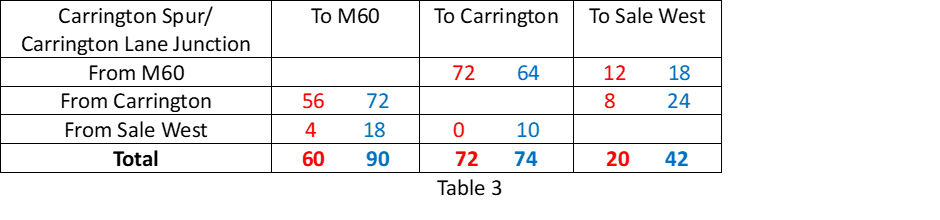
Table 1 shows the average number of cars per hour, during peak times, at the junction of the Carrington Spur and Carrington Lane in Sale West. The red data was recorded during school term time and the blue data was recorded during school holidays.
As expected, the number of cars increases around this junction during term time. The data shows during term time there are almost four times as many cars travelling from the M60 to Sale West. Also, the number of cars travelling from Carrington to Sale West is more than double during term time and the number of cars travelling from Sale West to Carrington is more than tripled.
On average, a total of 2,728 cars pass through this junction during peak times. During term time, 48% of the car traffic from the M60 is heading towards Sale West and 43% of the traffic heading towards the M60 is from Sale West. Additionally, 39% of the traffic from Carrington is heading towards Sale West and 47% of the traffic from Sale West is heading towards Carrington.
Other observations at this junction are:
Traffic queuing along the Carrington Spur Road from the M60.
Traffic queuing along Carrington Lane towards the M60.
Other routes were flowing freely.
2 buses maximum during the survey period.
Table 2 shows the average number of cars per hour during peak times at the junction of the A6144, Flixton Road and Isherwood Road in Carrington. The red data was recorded during school term time and the blue data was recorded during school holidays.
As expected, car traffic increases during term time, with the exception of those vehicles headed towards Isherwood Road. During term time the car traffic from Carrington to Flixton increases by almost five times. 62% of the car traffic from Carrington is headed towards Flixton. It is also interesting to see that 36% of the traffic headed towards the M60 is from Flixton.
Other observations at this junction are:
All traffic was flowing and there was no queuing at any junction.
Some traffic was travelling at excessive speeds, including HGVs.
3 buses maximum during the survey period.
According to the data in the Transport Strategy, 875 cars travel from Partington and Carrington to Urmston (the report does not mention Flixton) on a daily basis. We recorded 678 in one hour during one peak time and 282 and hour during non-peak time. It suggests that the data in the report is an underestimation for traffic moving in this direction.
The data in the transport strategy is not as specific as the data we collected but assuming the traffic from Carrington and Partington heading to ‘Sale West’ and ‘10km inside GM’ is the traffic headed towards M60, then their data suggests there are 10,587 cars per day travelling along the A6144 between Isherwood Road and the Carrington Spur Road. Our data shows 663 cars during peak time and 502 cars during non-peak time per hour. Assuming two peak times and 10 hours of non-peak traffic, that is a total of 6,346 cars travelling along this route. This time, the data in the report seems an over-estimation for cars travelling along this section of the A6144.
We will repeat our traffic count in the coming months, to test the validity of this result.
HGV Traffic
The data shows that during peak times there are approximately 152 heavy goods vehicles at the Carrington Spur junction and 213 at the Isherwood Road junction per hour. At non-peak times, there are 208 and 206 respectively. This suggests that HGV traffic is consistent irrespective of peak or non-peak times and is in excess of 2,000 per day. This figure will increase significantly as the proposed new warehousing is built.
Conclusions
Our data shows that:
The A6144 Carrington Lane in Sale West has as much car traffic as the A6144 in the direction of Carrington, as 48% of the traffic from the M60 turns towards Sale West during peak times.
The A6144 between Isherwood Road and the Carrington Spur has less car traffic than that suggested in the report.
There was no queuing traffic at the junction of the A6144 and Flixton Road during peak time. There was, however, significant queuing on the Carrington Spur and on Carrington Lane.
There is a massive increase in car traffic during term time indicating that there is insufficient public transport for students to get to school and a large proportion of students are travelling to schools from either outside the catchment area or from outside the borough.
Considering the findings of this data, how will the relief road reduce the traffic issues highlighted?
The biggest issue for the residents of Carrington Village has always been the large number of heavy goods vehicles that pass their front door every day. The existing A1 Road could be opened immediately to redirect HGVs away from the village. This would be a quick win (if the businesses in Carrington are willing to use that road).
Partington is experiencing housing development on a huge scale. The new developments on Lock Lane, Hall Lane, Oak Road, Heath Farm Lane and the Greyhound will create another 1,291 dwellings. Despite these developments increasing the number of houses in Partington by 38%, the routes in and out of Partington will remain the same. Only after the cars and buses have contended with the congestion in Partington itself, can they access the proposed relief road further along the A6144.
For residents in Sale West and Ashton on Mersey to benefit from the proposed relief road to Carrington, they will have to access it from Carrington Lane which is already heavily congested even before the new relief road joins this junction.
In essence, residents in Carrington Village will only benefit if HGV traffic moves onto the existing A1 Road. Residents in Partington, Sale West and Ashton on Mersey will have to queue in traffic in their towns before they can access the relief road. The new relief road, which will cost at least £76 million offers no relief to these residents who will see the population in their area increase significantly as a result of the Places for Everyone Plan. There will be an additional 2,260 houses in Partington and Warburton, 1,443 in Sale West (in addition to the 263 already with planning permission) and 603 in Carrington Village.
So how can this Transport Strategy justify such significant expenditure on a road that offers no solution to traffic issues that already exist?
There are other considerations here too:
Why hasn’t the A1 Road already been opened to HGV traffic to resolve the issues in Carrington Village?
Why are so many students being driven to school?
Do the school admissions policies in Trafford need reforming?
Does the Education authority or TfGM need to look at providing school buses?
The data shows that it is school traffic and heavy goods vehicles that create the congestion along the A6144. These are the issues that need addressing rather than spending £76 million on a scheme that will not solve the transport issues that have plagued this area for decades. This money could contribute towards the ‘scenario 3’ solution in the Transport Strategy and should be invested in long term, sustainable passenger and freight transport interventions.
There are several options that could be considered, such as:
opening the railway bridge between Irlam and Partington to give residents access to trains
opening up the ‘greenway’ and the former railway line from Partington to Altrincham to give residents access to trams
revisiting the 2012 Local Plan option to build a bridge from Carrington to Port Salford.
These are long term sustainable options that will reduce congestion and open up Greater Manchester and the rest of the UK to residents of these local areas.
What we need is a Transport Strategy that meets residents’ requirements, why isn’t Trafford talking to us about it?
On the positive side, the Council has a wide range of responsibilities and there are areas for which Officers and Elected Members should be congratulated but ………..
the report highlights (paragraph 1.6) that
“The priorities for 2021-2024 are described as ‘better health, better jobs, greener future’ as outlined below:
Reducing Health Inequalities Working with people, communities and partners, particularly in deprived areas, to improve the physical and mental health of our residents. Supporting people out of poverty Tackling the root causes to prevent people from falling into poverty and raising people out of it. Addressing our Climate Crisis Leading the way in our region’s response, reducing our carbon footprint and tackling the impact of climate change”.
So, how does the New Carrington Allocation fit with those priorities?
It contradicts each of them!
Reducing Health Inequalities:
Carrington Moss currently provides deprived communities with a huge area of free to access green space, which will no longer be available due to the proposed development of 5,000 homes, 350,000 m2 warehousing and the plans for 4 major new roads. The moss currently has:
almost no traffic, so no air, noise, light, vibration or water pollution – fresh air to breathe (for both humans and wildlife), a peaceful environment for those with anxieties or other wellbeing issues, an area where you can hear and see red listed birds and other endangered wildlife, encouraging outdoor activities and hobbies that improve the health of local people
local residents participate in a number of sporting and recreational activities on Carrington Moss, including those professional athletes and children attending the Manchester United or Sale Rugby training grounds, the horse riders who use many of the circular routes (there are over 1,000 horses stabled on or around the moss) and the walkers, cyclists, bird watchers, nature spotters, photographers, artists …. the list goes on!
Supporting people out of poverty:
in the plans for the area, there is only one transport option being funded and prioritised – and that is a new road! So, those in transport poverty (and there are many in the local area who cannot afford to run a car) will have no benefits from this allocation (Trafford itself describes the area as currently having poor public transport provision)
furthermore, the only job opportunities being provided by the allocation are warehousing, which is very limiting in terms of both career choices and wages
and those currently working in the rural economy in the area (and their supply chains) will have their job or volunteer opportunities decimated or eliminated entirely!
Addressing the Climate Crisis:
the current habitats on Carrington Moss are essential to support the mitigation of climate change and the achievement of Trafford (and the region’s) carbon neutral ambition
these habitats include the 335 hectares of peat moss itself (which can be restored to capture and store huge volumes of carbon), Grade 2 agricultural land (which is perfect for growing crops to support the food security of current and future generations), large areas of woodland (which again are a great carbon store and provide shelter and food for the red listed birds and endangered wildlife) and wetlands (which capture and store huge volumes of surface water, that will have to be directed elsewhere when the area is concreted over
there are also a number of sites of biological importance and sites of special scientific interest on and around Carrington Moss, these are extremely important for conservation and nature’s recovery.
In addition to all of these benefits, Carrington Moss also has fantastic historical value. Obviously, the peat has been forming for thousands of years, horses have been ridden over the moss since medieval times, the Victorians used it for dumping night soil and waste (the remnants of the train tracks remain) and, in the Second World War, it was used as a decoy bombing site to save the centre of Manchester. As typical flat peatland terrain, it also boasts expansive views (you can see the hills over 20 miles away on a clear day). Imagine the future, with those views changed to HGVs thundering down the planned new road and 22m warehouses blotting out everything else in the landscape!
Paragraph 1.9 of the Council’s report confirms that a “new Corporate Plan is expected for July 2024”. Given the Places for Everyone Plan significantly reduces the protections brought in by the 2012 Core Strategy, ignores the advice of Natural England and unnecessarily decimates the largest natural capital asset in Trafford, can we expect a similar weakening of Trafford’s future corporate plan priorities?
Time will tell!
PS The Greater Manchester Combined Authority has published the responses to the Places For Everyone modifications consultation, our friends at Steady State Manchester have included the link in their short blog, available here.
PPS The Friends of Carrington Moss are working with other Greater Manchester groups to determine the next steps in our campaign to prioritise brownfield development across the region (and let’s face it, there is a lot of brownfield land that could be used, and GM has received significant public funding to regenerate it)! We’ll keep you updated as more information becomes available.
Some very interesting points arose at the Executive meeting (held on 25th September) which approved the Places for Everyone Modifications Consultation
Councillor Patel, for example, suggested that Green Belt campaigners have taken a “narrow view of how future development can be accommodated”. This is utterly untrue, totally uninformed and highly insulting. Green Belt campaigners have used their own time, their own money and their own, and independent, expertise / advice to consider ALL aspects of the Plan. The Chair of the Friends of Carrington Moss was one of the very few people to attend ALL of the Examination Hearings about the thematic policies. To describe the work of this and other Green Belt groups as narrow demonstrates the complete lack of engagement the ruling elite has had with the community, and their unwillingness to conscientiously consider the feedback we have been giving (contrary to the Gunning Principles).
The same is true of our concerns about the lack of evidence that has been provided.
Let’s be clear, a development of 5,000 homes is a new town and should have been subject to much more detailed scrutiny. Partington currently has around 3,500 households. It will be dwarfed by the proposed new town and the requirements of the new community. The New Carrington development is the largest in the Places for Everyone Plan, representing 25% of Trafford’s housing requirement, the vast majority of which will be built in just one Trafford Ward!
The main report, which can be found in the papers for the Executive Committee at this link, sets out a series of implications of the Places for Everyone Plan. It is a very misleading set of indicators.
Indeed, Councillor Coggins raised the greenwashing in the report, particularly in relation to the carbon emissions. Councillor Patel felt that it would be difficult to summarise in a short paragraph but it is important that such momentous decisions (this is a 17 year plan), that will have a huge impact on current and future communities should be based on an honest and transparent assessment of the implications. There is more information about the carbon emissions implications in the analysis below.
Councillor Coggins raised a number of questions on behalf of the Friends of Carrington Moss, to which Councillor Patel suggested that FOCM should put their questions to the Executive so they can make a detailed response. We would be delighted to do so, but other emails sent to Councillors have resulted in no response from the Executive.
The recording of the Executive Committee can be found at this link. The item about Places for Everyone starts at 4:57 and the discussion lasts for around 40 minutes.
Read on for a more detailed analysis of the content of the Executive meeting.
Councillor Patel’s opening presentation, sadly, focused on the spin, suggesting that:
The plan is “the best route for a sustainable future for Trafford”
Incorrect given Trafford is proposing development on a peat moss, Grade 2 agricultural land, woodland and wetland habitats, without committed funding for public transport and/or sustainable freight.
There is “huge public interest in the plan’s adoption”
There is huge public interest in removing the Green Belt allocations. There were, for example, 27,000 responses objecting to the release of Green Belt in 2016, these objections have not subsided.
Implementation of the plan represents:
“sustainable regional growth”
“better future for communities”
“tackles the housing crisis”
investment “in skills, jobs and productivity”
a “robust strategic framework of environmental protections, including nature’s restoration and significant enhancements to biodiversity across GM”
Sustainable! – when the growth is the equivalent of creating two new boroughs in GM? Communities will suffer from the impact of increased air, noise, light, vibration and water pollution! The housing crisis is the lack of social housing – the affordable housing target has been removed from policy! The investment in jobs in New Carrington is limited to warehousing! A robust framework that proposes development on a peat moss, Grades 1, 2 and 3 agricultural land, woodland and wetland habitats! There is not one single allocated site in the whole of Places for Everyone with a purpose of enhancing nature’s recovery!
The plan will “maintain a new and defensible Green Belt which will endure beyond the plan period”
Local Authorities can release more Green Belt in their Local Plans – the previous commitment preventing this was not included in P4E Policy.
The “Inspectors have rejected a number of the proposed new additions to the Green Belt”
An interesting way of phrasing the situation, which has led to an increase in Green Belt release. The legal issue that required Green Belt Additions to be removed from the plan was raised by Peel in their regulation 19 consultation response. The GMCA initially categorised the response as “No Change Considered Necessary” but in March 2023, the GMCA confirmed that 32 of the 49 Green Belt Additions did not meet the exceptional circumstances test required.
The “removal of an overarching GM affordable housing target” has “been replaced with site specific allocations reflective of local needs and viability”
Again, an odd way to phrase the removal of this key principle in the plan. The site specific allocations always had an affordable housing target. In fact, the New Carrington affordable housing target was previously 30% but has now been reduced to 15% (the Planning Inspector refused to allow Trafford to remove it altogether, although this was proposed). Later in the meeting Councillor Patel suggested that the Inspectors had requested the Affordable Housing target be removed from policy but this is incorrect, this modification was proposed by the GMCA.
Green Belt has dominated the debate and has been detrimental to the overall understanding of the plan
It has not been detrimental to the understanding of the overall plan for those us who have been fully absorbed in it over the last several years. Given that 27,000 residents objected to the release of Green Belt in 2016, it should be no surprise that a plan that persists in unnecessarily demanding the loss of nature/biodiversity-rich sites continues to be challenged.
Brownfield and urban development will play the most significant part in land identified for development
Of the warehousing developments (for which GM has added a 75% buffer/contingency to their requirements), 49%will be built on unsustainable Green Belt locations. For housing, there is sufficient existing brownfield land supply to build a number of homes that is the equivalent of creating 2 new boroughs in Greater Manchester. Green Belt release is unnecessary and unsustainable!
“in order for the right mix of homes and jobs to be built in the future, some Green Belt release is necessary”
So, a plan that only focuses on market housing and warehousing is the right mix of homes and jobs? That is not the view of many in the community. No targets for social housing, no identification of land to support gypsy/traveller/student communities and no aspirations for the rural economy (despite rural areas comprising almost 50% of Greater Manchester’s land).
This Administration considers this is an acceptable ask of the Green Belt in order to provide the land supply needed to address the housing crisis
How many homes for social rent (which is the housing crisis given that considerably more market houses have been built than households formed) are planned for the Green Belt? This will be monitored but we believe it will be NONE! If tackling the housing crisis is the key consideration, why is Green Belt land being sacrificed for warehouses?
Councillors supporting the development also made some rather misleading statements:
Councillor Williams stated that “in unlocking the Carrington site for development we will be able to see one of the largest single brownfield sites in Greater Manchester unleashed for residential housing development”
Incorrect, the brownfield sites already have planning approval, which has been given outside of Places for Everyone (around 1,200 homes in Carrington and at Heath Farm Lane). It is the Green Belt sites that will be “unlocked” by the plan! In addition, the concerns of the Health and Safety Executive could restrict the regeneration of the brownfield employment sites.
Councillor Wright suggested that the people of Partington will have “access to good jobs through the creation of the Carrington Relief Road”
Again this is incorrect. Only warehousing jobs are being created at Carrington and these are not known for either their quantity or their high pay. Access to jobs further afield will be impacted by the huge increase in traffic – 5,000 homes and 350,000 m2 warehousing will add a significant number of cars and HGVs to local roads and, as there is no commitment to funding for public transport, challenges with local school places and other council services, residents will continue to have limited choices. There are no proposals at all for sustainable freight transport options. The existing Partington community, which has a much lower proportion of car ownership than elsewhere in Trafford, will not benefit in any way from the estimated £80m expenditure of the Carrington Relief Road! Congestion will impact their travel even more in the future than it does today.
Councillor Patel suggested (in response to a question from Councillor Coggins on behalf of the Friends of Carrington Moss) that the Rural Economy was covered in the Examination Hearings and that the Executive do not believe that there is any specific risk to economic activity because of the plan
This is both incorrect and astounding! There is no mention of the Rural Economy in the plan, it was not discussed at the Hearings (other than confirmation that it is subordinated to Local Plans) and no evidence is included in the Examination database about the impact to the Rural Economy as a consequence of the plan. If Trafford has evidence that there is no specific risks to farming, stabling and other rural businesses (and their supply chains), the data that confirms this should be shared. Loss of Grade 2 best and most versatile agricultural land, loss of access to stabling, loss of supply chain contracts, etc cannot be achieved without a severe impact to those businesses!
In response to a question from Councillor Butt, Councillor Patel suggested that “the reference to Carrington Moss is not reflective of an extent of large peat reserves right across the site, it fluctuates tremendously and the area of deep peat resides in the centre of the site”
In 1995 an academic study confirmed there were 325 hectares of deep peat at Carrington Moss (I’d say that is reflective of a large extent of deep peat)! Natural England, the government’s adviser for the natural environment in England, do not agree with the development on the site and confirmed during the Examination that there is an inferred peat extent of 280 hectares on the site. Whilst it is true that peat thickness does fluctuate, it should also be noted that the Heath Farm Lane Ground Investigations found that the “peat is relatively thick in this area (up to c. 2.5m)”. This is on the edge of the site, not in the centre!
Councillor Ennis asked how convinced the Executive is that Trafford will get any Affordable Housing out of the plan. Despite hearing the concerns of Councillor Ennis about the definition of the term “Affordable Housing”, Councillor Patel questioned “why local politicians would somehow object to a housing plan that will deliver such tremendous amounts of Affordable Housing”. We think it is astonishing that the Executive have such confidence in the amount of Affordable Housing that will be delivered. It is clear that communities will need to monitor that these and other aspirations are achieved given the Executive appear to believe developer behaviours will change.
Councillors Paul and Duncan from Manor Ward defended the peat moss and raised questions on behalf of Friends of Carrington Moss including a question about the lack of ecological evidence in the plan (given the size and scale of this development, such evidence should have been available prior to site selection). Councillor Patel advised that she will circulate a detailed note in response to that question. We hope it will be transparently available to residents.
Communities are delighted that the Conservative Party continues to pledge to retain the Green Belt, despite Sir Keir Starmer’s recent vow to concrete it over!
But …….
That pledge does not secure actual protection for our Green Belt.
Despite the National Planning Policy Framework (NPPF) paragraphs 140 and 141 suggesting that ONLY WHEN “exceptional circumstances” are “fully evidenced and justified”, together with a demonstration that “all other reasonable options” have been considered, can Green Belt boundaries be amended, frequent approvals of Green Belt developments occur (including in our region).
Clearly those “exceptional circumstances” are not a hard test to meet!
Many communities nationwide are campaigning to protect Green Belt sites which comprise irreplaceable habitats (peat moss), Grade 1, 2 or 3 agricultural land, woodlands and wetland habitats. Our politicians are unnecessarily putting them under threat of development and the current environmental protections are just not robust enough, with the requirement to make “as much use as possible of suitable brownfield sites and underutilised land” (paragraph 141) a mythical aspiration rather than an objective of the NPPF!
Just one example of those poor environmental protections is the risk to Greater Manchester’s peat mosses (many of which are allocated for significant development in the Places for Everyone Plan).
The Government is taking a very slow pathway to protect peatland soils, despite the increasing recognition of the ecosystem services peat provides. Since 2009, there has been a commitment to Safeguarding our Soils, recognising that soils play a huge role in the fight against climate change (and helping us manage its impacts). In the 2011 Defra Natural Environment White Paper, the Government recognised the natural capital asset of soils. The 25 Year Environment Plan (published in 2018) restates the aspiration to manage our soils sustainably by 2030, including improving soil health and restoring and protecting our peatlands. More recently, the England Peat Action Plan (2021) sets out the Government’s vision to reverse the decline of our peatmosses. The aim is to prevent further loss of peatland habitats, to restore more peatland landscapes and the document recognises that rewetting peatland areas and returning them to their natural state could make a significant contribution to achieving our targets for reducing carbon emissions, as well as having other benefits for water quality, nature and flood mitigation.
Yet, there is still no moratorium on builds on peat mosses and no commitment to change in the recent NPPF consultation.
There have been many interventions from Natural England (which have been summarily dismissed by the GMCA). Yet, even though there is no actual NEED to build on these precious, irreplaceable habitats and despite every district declaring a climate emergency, some of Greater Manchester’s most important natural capital assets are at risk of destruction!
What about Sir Keir Starmer’s commentary?
The Labour Party position is not a surprise to those of us based in Greater Manchester. The Save Greater Manchester’s Green Belt Group wrote to Sir Keir in January 2023, copying members of his Shadow Cabinet, GM’s Labour Mayor and Labour MPs (you can read our letter at this link). To date, we have received no acknowledgement nor a reply from any of the recipients.
Clearly engagement with communities is not a priority for them.
In fact, as a member of a recent Question Time panel (27th April), Lisa Nandy confirmed (in a discussion about housing), that the Labour Party are working with developers, investors, Councils and planning authorities. She made no mention of working with communities.
In this Times article Sir Keir says “Labour would give councils and residents more power to build on green belt land to meet local housing need”. He continues “It’s important for local areas to have the power to decide where housing is going to be”.
In fact, as mentioned above, Local Authorities are already able to make changes to, or build on, land designated as Green Belt. Conversely, residents have NO power within the planning ecosystem!
Research by CPRE highlights that only 1 in 10 homes on the Green Belt are classed as affordable (using the current NPPF definition). The same report suggests that the density of homes built on the Green Belt land has remained at just 14 dwellings per hectare. This is a quarter the density of developments outside of the Green Belt.
In Labour controlled Greater Manchester, 27,000 residents opposed Green Belt development in the first consultation for the spatial plan in 2016. What is now the somewhat disingenuously named Places for Everyone is currently being examined by Planning Inspectors and aims to release 2,430 hectares of Green Belt.
Residents still oppose it but our Labour Councils, the Labour Mayor and Labour MPs are not listening!
As mentioned above, and, as outlined in our letter to Sir Keir, there is no actual NEED to build on the Green Belt, not just here in Greater Manchester but the nationwide picture reflects a similar story.
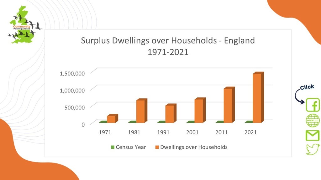
Communities are confused by the commentary from politicians and others in relation to land use. The assertion that there is a backlog of 4.3 million homes is typical, yet the facts do not bear out misleading statements such as this. Political rhetoric repeats these fictional assertions, yet as the following infographic shows, there is not only a surplus of market homes, brownfield is not being prioritised, homes are allowed to remain empty, despite over 1.2m people on the housing waiting list and developers are allowed to hold on to land with planning permissions without building the approved developments.


You must be logged in to post a comment.