Monthly Archives: Jun 2024

Is the Carrington Relief Road really a relief road or just a green light to major development?

By Lorraine Eagling

Following my blog about the New Carrington Transport Strategy (8th March), I decided to carry out some more traffic surveys to further clarify my findings and conclusions (you can read the previous blog here).

I carried out surveys in the morning rush hour during the Easter Holidays and then mid-term time (the week the GCSE examinations started).  This time the data was taken between 8.10 and 8.30, whereas last time the data was collected between 8.30 and 9.00.  I wanted to confirm that traffic increased significantly during term time and what direction was the traffic flowing.

The following tables show the percentage of cars and vans travelling in the different directions at the two major junctions that the relief road is purportedly to relieve.

Car and Van traffic at the Junction of Carrington Spur, Carrington Lane and Banky Lane

Percentiles of traffic flow (cars and vans) during peak times in the Easter holidays April 2024 – average hourly total 1833 vehicles

Percentiles of traffic flow (cars and vans) during peak times and term time April 2024 – average hourly total 2160 vehicles

There were tailbacks from the M60 heading towards Sale West.

Conclusions drawn from these tables regarding car and van traffic at this junction

  • During term time 63% of the traffic from the M60 is travelling towards Sale West, therefore, would not use the new relief road.
  • During school holidays 49% of the traffic from the M60 is travelling towards Sale West, therefore, would not use the new relief road.
  • The majority of the traffic from Sale West during school holidays and during term time (69% and 60% respectively) is travelling towards the M60, therefore, would not use the new relief road.
  • There is a 28% increase in the number of cars travelling from Carrington to Sale West during term time.
  • The busiest route (the highest traffic count) was from Sale West both during term time and school holidays.

This suggests that the majority of the traffic travelling from the M60 and the majority of the traffic from Sale West would not use the new relief road.  Also, the increase of 28% in traffic using the relief road during term time is school traffic which could be addressed using school buses. 

Car and Van traffic at the Junction of Carrington Lane, Flixton Road and Isherwood Road

Percentiles of traffic flow (cars and vans) during peak times of the Easter holidays April 2024 – average hourly total 2204 vehicles.

Percentiles of traffic flow (cars and vans) during peak time and term time April 2024 – average hourly total 3081 vehicles.

There were no tailbacks at any of the junctions, however traffic travelling towards the M60 was slow due to an accident on the M60 at Eccles.

Conclusions drawn from these tables regarding car and van traffic at this junction

  • During term time 64% of the traffic from Carrington/Partington is travelling towards Flixton.  This means that the majority of the traffic from Carrington and Partington will not use the section of the relief road that runs parallel to the existing A6144 between Isherwood Road and the Carrington Spur.  During school holidays this figure is 43% which is still almost half the traffic. 
  • During term time 49% of the traffic from the M60 travels toward Flixton and during school holidays this figure is 34%
  • It would be more direct to travel along the existing A6144 from the M60 if you were heading towards Flixton as you pass through one junction as appose to two junctions if you were to use the new relief road.  If we consider term time traffic, 37% of the vehicles from the M60 head towards Carrington.  Of this, 49% heads towards Flixton (and will most probably use the existing road), 51% heads towards Carrington and would probably use the new road.  So, that means 51% of the 37% of traffic, which is a total of 18% of the traffic coming off the M60, would benefit from using the new road.

Overall, the data shows that traffic increases significantly during term time.  At the Banky Lane Junction, the heaviest traffic flow is between Sale West and the M60.  At the Isherwood Road junction, the heaviest traffic flow is between Carrington and Flixton.  So, why do the council feel there is a need for a new road between these two junctions, that will cost in excess of £76 million (the figure keeps rising) – rather than seeking to use public money on alternative, more sustainable options?

As local residents have constantly explained, the major issue with the roads in this area, is the high number of HGVs passing residents’ homes, causing structural damage due to the vibrations, as well as air, noise, light and dust pollution. 

The following tables summarise the numbers of HGVs recorded during these surveys, some of which were travelling at excessive speeds.

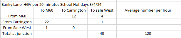
HGVs at the Junction of Carrington Spur, Carrington Lane and Banky Lane

HGVs at the Junction of Carrington Lane, Flixton Road and Isherwood Road

We can see from these figures that the numbers of HGVs are consistent irrespective of the time of year.  Also, the numbers remain consistent whether it is peak time or not, as evidenced in previous traffic surveys.  Assuming a 10-hour working day (although residents will testify that these vehicles are running through the night), this is an average of 1500 HGVs a day.

You have to question why all of these vehicles pass residents, homes when there is already a road that bypasses Carrington Village?  Why hasn’t this road (the A1 service road) already been improved and made available to take HGVs off the A6144 through the Village and alleviate the long suffering of local communities?

During the course of doing these traffic surveys the only congestion I witnessed was along the Carrington Spur Road and that was as a result of an accident on the M60 at Eccles. 

Trafford Council’s website states

“The current route via the A6144 and Manchester Road is heavily congested by both cars and heavy goods vehicles (HGVs).  Affecting the lives and journey times of people living in the area. 

To provide easier and safer journeys, Carrington Relief Road will provide:

A new convenient route (Option F) to encourage HGVs to divert away from the congested A6144

Deliver improvements to make travelling by bus easier and safer

Provide new routes to enjoy when travelling by foot, bike and horse”

This statement is questionable.  Firstly, the route is only heavily congested when there are issues on the surrounding motorway networks.  Secondly, there is already an alternative route for HGVs that could be opened to divert HGV traffic away from the A6144.  Thirdly, we already have routes to enjoy when travelling on foot, by cycle or on horseback – these public rights of way could be improved at a significantly lower cost, bringing considerable health and wellbeing benefits (which will not be generated if residents are walking, cycling or horse riding next to a very busy major road).

The truth is this road is not being built improve the lives and journey times of people living in the area.  As Trafford Council’s own ‘Carrington Relief Road Environmental Impact Scoping Report’ states

“1.2. The key objective of the new Carrington Relief Road is to provide sufficient capacity within the transport network to deliver growth of housing and employment in the wider New Carrington masterplan area, and realise the socio-economic benefits of the future development. The redevelopment of this Site provides an opportunity to deliver a new link road for Trafford that will facilitate future phased development of c.5,000 new homes and 360,000sqm employment floorspace”.

So, Trafford Council admit that this relief road is not about improving the lives of existing communities but it’s to give the green light to build the biggest housing and industrial development in Greater Manchester.  Once again, the communities of Carrington, Partington, Sale West and Warburton have been failed. 

That Environmental Impact Scoping Report also recognises that through traffic will be induced into the area

Traffic flows are likely to increase due to the improved desirability of the route” (paragraph 14.46)

and, if the 5,000 new homes and 360,000sqm of warehousing are built, it will not be long before the new relief road is at capacity and nothing has been gained but so much will have been lost (a 335 hectare peat moss, Grade 2 agricultural land, woodlands, wetlands, biodiversity, endangered species).

Trafford Council has failed to deliver on their promises of good public transport in successive Local Plans. 

Instead of spending in excess of £76million on a short-sighted plan, other options should be seriously considered and pursued, such as opening the train line linking Partington with Irlam and Timperley.  Long term prosperity and equality needs a public transport network that provides connectivity, reliability and sustainability for everyone and this is Trafford Council’s opportunity ensure our communities get this, at long last!

FOCM Response to CRR EIASCO

The Friends of Carrington Moss have responded to the Environmental Scoping Report for the Carrington Relief Road. Take a look at the issues we identified in our letter below:

Dear Planning and Development Team

The Friends of Carrington Moss are responding to the EIASCO Scoping report for the Carrington Relief Road (CRR) as there are a number of inconsistencies, errors and concerns in relation to the document.  We set out the most important issues below and in the attachment.

The document confirms that (paragraph 1.2) the key objective of the road “is to provide sufficient capacity within the transport network to deliver growth of housing and employment in the wider New Carrington masterplan area, and realise the socio-economic benefits of the future development”.  Yet, it has been sold to existing residents as a means of addressing their transport and isolation issues – which it will not do for the following reasons:

  • It will significantly increase traffic in the area, as acknowledged within the report
  • It does not provide any relief from the huge and increasing number of HGVs that travel on local roads every single day (along with the consequential air, dust, noise, light, and vibration pollution)
  • It will not bring any benefits to Partington or Sale West residents and whilst it is “intended to take traffic away from the A6144 Carrington Lane and Manchester Road” (paragraph 16.63), the expected significant increase in traffic levels is likely to result in Carrington Village being surrounded by a highly congested road network.

We do not believe these issues will be adequately tested within the Environmental Assessment (based on the contents of this Scoping report).  In addition, whilst the document purports to bring public transport benefits, other than delivering an increasingly congested road surface, the provision of improved public transport services is outside the scope of the scheme (despite paragraph 16.3 suggesting that the “new relief road will provide significant upgrades to public transport”).  An alternative scheme to reopen the former railway lines would bring significantly more benefits to current and future local residents.  We do not agree with the demolition of the Burford Bridge as that will restrict opportunities for rail connectivity to Carrington businesses in the future.

One of the main inconsistencies is that the document repeatedly states that the CRR “will comprise 4.1km of single carriageway road”.  Yet, the report also suggests that part of the road will be dualled.  This will, of course, result in greater land take, higher costs and more congestion (especially for West-bound traffic).

We are concerned that dualling even part of the road will result in inappropriate speeds (drivers tend to exceed the limit, rather than drive more slowly than allowed) and we will object to the proposed 40mph speed limit on the Eastern extent of the road (paragraph 4.38, see also paragraph 14.46).  This will be dangerous for those crossing, especially with horses, dogs or young children and will also lead to more wildlife casualties.

Whilst the document confirms (eg paragraphs 4.138, 9.21) that the CRR route is in Flood Zone 1 (the lowest risk of flooding), we are concerned that the lack of local knowledge underestimates the level of water captured in the area (please see the videos and images on the Carrington Lake page on our website which shows extensive surface water flooding on the site of the road).  According to the document it is intended that all the Attenuation Ponds will discharge into the River Mersey.  We are rather alarmed that this will lead to the potential for the Mersey to breach its banks more frequently than it currently does today.  This will have an impact on local residents and users of the Mile Road in Flixton.

In addition, Natural England suggested (at the Places for Everyone Examination) that there are 335 hectares of restorable peat at Carrington and we do not believe the impact of the proposed hydrological changes on the peat has been fully covered by the EIASCO Scoping exercise.

We will review the comments of the statutory consultees in relation to the issues scoped in and scoped out once they become available and we may have further comments at that time but we would like to highlight that Operational Vibration (paragraph 13.12) should be scoped in, rather than scoped out because of the number and weight of the HGVs that will travel the full length of the CRR (which could have significant adverse effects for the proposed new homes at the Eastern end of the site and the existing businesses at the Western end).

Furthermore, paragraph 16.23 dismisses the impact of the scheme on businesses within Aston upon Mersey but does not consider the productivity implications of the increased traffic and the delays they will be facing both at the Carrington Spur junction and on the Spur itself.

Whilst we appreciate that the document acknowledges (eg paragraphs 10.63 and 10.65) that the construction of the road will have significant effects, we do not believe all the impacts on human and wildlife health have been fully considered.  The Air Quality measures, for example, include locations way beyond the red line boundary (eg TR27, SAIN, TR25) and, as acknowledged in the report, refer to the Covid 19 period.  We are unclear whether the DEFRA modelling anticipates the level of development, especially the huge and increasing numbers of HGVs.  You may already be aware that Carrington Parish Council has installed an Air Quality Monitoring System on Manchester Road opposite the entrance to the business park.  The data from this system should be considered within the Environmental Assessment, along with relevant monitoring locations within the red line boundary.

The document confirms, in relation to Greenhouse Gas emissions, (paragraph 18.10) that “At the time of drafting this scoping report, only preliminary data and background research is available to inform the decisions”.  We would welcome further information as soon as it becomes available.

With all of the above and our attachment below in mind, we would appreciate the opportunity to discuss the road design and intended future actions in detail with the project team.

Kind regards

Marj Powner (Chair)

On behalf of the Friends of Carrington Moss

Summary of Issues and Concerns

Consultation

It is with great disappointment that we note that communities do not feature in this Environmental Scoping exercise in any way, shape or form, despite residents being the key stakeholder and the people with the most knowledge about the area within the red line boundary. 

Section 3 of the Scoping Report does not make it clear that there is a role for communities in the Environmental Scoping exercise (see paragraph 3.4).  This is a huge omission as the Scoping exercise should take into account inputs from (among others), the Parish Councils, the Friends of Carrington Moss, Trafford Wildlife, Peak and Northern Footpaths Society, and the British Horse Society.  We are the organisations with the in-depth knowledge of this site.  There should also be inputs from, for example, of the children with Special Educational Needs who regularly use the PROWs at the Eastern end of the site, between the Carrington Spur and Isherwood Road.

Paragraph 3.13 states that “Engagement with key stakeholders has been regularly undertaken over a number of years”.  This is incorrect.  Communities have only been involved in one very limited engagement exercise and, even then, our inputs were not included in the report to Committee (neither was the Natural England response). 

There is no mention of consultation in relation to the Environmental Scoping (ES) exercise in Sections 7, 8, 9 and 10

Section 11 (Biodiversity) suggests that future consultation for the ES will be carried out only with the GMEU.  Whilst their input is very valuable, the reserves on Carrington Moss are maintained by Trafford Wildlife and are also well known by Cheshire Wildlife Trust.

Section 12 (Socio Economic and Human Health) does mention “other interested parties” (paragraph 12.3) but it is not clear which organisations this refers to.

Sections 13, 14 and 15 suggest future ES consultation will only be carried out with statutory consultees.  Sections 16, 17 and 18 state that no consultation with statutory bodies has been carried out to date and does not mention involvement of communities.

Increasing Traffic Volumes

The document repeatedly highlights the impact of increasing traffic, with many references to the number of HGVs (see, for example, paragraphs 4.46, 4.47, 4.114, 7.5, 7.6, 10.72, 11.57 and 14.46), emphasising that design features will be needed to accommodate increased traffic volumes (including, for example, a signalised junction at the Lyondell Basell compound, along with a dedicated left-hand turning lane, and alterations to the Banky Lane junction to accommodate future traffic demands).  The report suggests that the CRR is planned to “limit the growth of road traffic” to single carriageway capacity (paragraph 7.5).  We do not believe the Environmental Assessment will test that premise (based on this scoping document), especially as that paragraph 11.57 suggests that traffic volume (and air pollution) increase is only a possibility, which is ludicrous given that the purpose of the road is to support extensive development.

The Friends of Carrington Moss has offered to share the outcome of our traffic counts with the project team to supplement the reliance on other outdated information (paragraph 7.14).  Our counts are up to date, taken by residents, in specific locations on the existing route, at various times (including during term time and school holidays).

Health and Wellbeing of existing residents and wildlife

Section 12 (Socio Economic and Human Health) appears to underestimate and minimise the potential impact of the scheme on existing residents.  We would like to see more emphasis on:

  • Alternative sustainable freight transport – rail and water
  • Alternative sustainable passenger transport – firm commitments to increase the bus services (these have been promised in the 2006 UDP and the 2012 Core Strategy)
  • The health implications of walking, cycling and horse riding next to over 3,000 HGVs a day and thousands of cars – rather than using the current safe, pleasant & healthy routes across Carrington Moss
  • The productivity benefits of green spaces and access to nature
  • The impact of the scheme on the health and populations of wildlife and birds (it seems the plan is to further reduce the already significantly depleted population of skylarks, for example, moving them elsewhere is not the answer)
  • The loss of recreational space and opportunities
  • Schools within the allocation area

There is a recognition that:

  • the prevalence of asthma and COPD in the Study Area is likely to be higher than could be anticipated at a national level” (paragraph 12.80)
  • the “Site LSOAs are within the 6-8th worst performing deciles nationally for air quality, and within the 8-9th worst-performing deciles nationally for sulphur dioxide (SO2) levels” (paragraph 12.95)
  • air pollution in Trafford generally (relating to fine particulate matter) is worse than regional or national levels” (paragraph 12.96)
  • There are significantly more people living with disability within the area surrounding the Site than Trafford generally, or nationally” (paragraph 12.111)
  • There is considered to be significantly higher prevalence of Asthma and COPD in the area surrounding the Site than could be anticipated at national level” (paragraph 12.113)
  • Air quality in the Study Area is considered to be poor, and the Site lies within the Trafford Air Quality Management Area” (paragraph 12.114)

Given the above, we would like more information about the proposed mitigation of the significant health impacts of the scheme.

Inaccuracies and Inconsistencies

It would also be helpful if the report was accurate.  Paragraph 16.6, for example, states that “the Site was traditionally dominated by a long-established Petrochemical works” and paragraph 12.90 states that the “area surrounding the Site is largely industrial in nature, dominated by the Carrington chemical works and power station, and business parks”.  That is incorrect.  These statements refer only to the Western part of the site, which is not contentious.  The Eastern part of the CRR will be constructed on Grade 2 agricultural land.  This part of the site is dominated by fields, woodland and extensive landscape views!  

Paragraph 4.3 suggests that the site “is located close to the SRN including the M60, M62, M6 and M56 Motorways” and paragraph 12.103 describes Stretford & Gorse Hill communities as being “close” to the Site.  What is the definition of close?

Paragraph 11.14 states that “Brookheys Covert is managed by the Cheshire Conservation Trust as a nature reserve”.  Cheshire Conservation Trust hasn’t existed for quite some time – it was a forerunner of Cheshire Wildlife Trust.  Brookheys Covert is owned by the National Trust and the community organisation Trafford Wildlife conducts conservation work on their behalf.

Paragraph 4.25 suggests that “Between the Redline Site Boundary and the A6144 Carrington Lane to the north of the CRR Route is Sale Sharks Rugby Club Training Ground“.  We believe this should say Sale Rugby FC Training Ground.

There is a lot of confusion about Wards, populations and communities, which is why it would be a good idea to involve resident groups in this exercise.  Paragraph 12.61, for example, states that “The Proposed Development is located within Trafford Local Authority Area which had a usual resident population of 10,291 people, according to Census 2021 data”.  Which area does this figure actually relate to?

Similarly, paragraph 16.16 states that “the overall proposal of new Carrington will provide approximately 5,000 new houses across a total area of approximately 179.7 hectares”.  This figure should be checked as the overall allocation area is 1,153 hectares (which will provide both housing and warehousing development), of which Green Belt is 169 hectares.

St Marys Ward is now called Manor Ward (paragraphs 12.24, 12.127).  In terms of Wards “immediately surrounding the Site”, if Davyhulme, Flixton and Urmston are considered to meet this criteria, then Broadheath and Bowdon Wards should also be included.  Paragraph 12.190 mentions Warburton Ward.  Warburton is a village, it is in Bowdon Ward.

Paragraph 12.24 also mentions that, for comparative purposes, Salford City Council and Manchester City Council will be used as a baseline.  On what basis are these Councils comparative to Trafford (they are both urban/City areas with very limited rural locations)?  A more appropriate Council to use would be Tameside (which has a similar land area and a similar population level). 

Paragraph 12.31 suggests that “the most important sectors, by total employment for Trafford is within the Professional, Scientific, and Technical Sectors, followed by business support services, and Retail”.  These are not the sectors being provided by the New Carrington development!  Further information is required about this analysis.

Similarly, paragraph 12.47 states that “there is capacity at Primary and Secondary schools across Trafford” and paragraph 12.51 states that “Trafford have firm plans to deliver 1,330 additional new primary school places on a permanent basis to cater for the additional needs, for the period 2023/24 to 2024/25”.  This is not consistent with our own research and again, we would welcome more information about this analysis.

Paragraph 12.54 does not mention dentists or access to hospitals, which will be key community facilities and paragraph 16.22 does not mention Manchester United or Sale Rugby FC as local businesses.

There is an ironic typo in paragraph 4.4 but of more concern is the inference that the Ship Canal is a beneficial transport corridor (to the Atlantic Gateway).  The alternative of making use of this sustainable transport option has been dismissed in favour of an unsustainable road solution.

Finally, we believe that this document needs a further review to ensure it is as up to date as it should be.  Paragraph 14.6, for example, states that the consultation on the Trafford Local Plan has recently closed.  We do not believe there has been a consultation on the new plan since 2021.  Paragraph 17.8 refers to the Environment Bill 2020, which became law in 2021.