Not current or new local communities in the surrounding areas, who will suffer from significantly increased traffic, more congestion and the health consequences of air, noise, light, vibration, dust and water pollution, many homes will also be at a considerable risk of flooding
Not horse riders, walkers or cyclists who frequently use the traffic-free routes on, across and around Carrington Moss, whose current safe, healthy and very pleasant trips will be fractured by huge volumes of traffic, they will be required to walk or ride alongside hundreds of highly polluting vehicles, travelling at speed, which will be unsafe, unhealthy and very unpleasant
Not the red listed birds or the endangered wildlife species that breed and feed on Carrington Moss, their homes will be destroyed, their foraging corridors shattered, their lives at risk as victims of roadkill
Government data makes it clear that there are many households in the area which do not have access to a car. Building a new road will not benefit them at all (but they will still suffer the health consequences of increased pollution that are caused by others driving through their areas).
Over the past almost 10 years, despite confirming that this area is poorly served by public transport, Trafford has been unwilling to explore more sustainable alternatives, such as those proposed by the Friends of Carrington Moss.
We hope you will support our campaign to remove the Eastern part of the Carrington Relief Road (CRR) from the plans. This will bring numerous benefits to local communities and users of the moss and will reduce the costs to the public purse.
The submission of a planning application for the road is expected before Christmas. Once it has been validated by Trafford’s planning team, the documents will be made public, and the Friends of Carrington Moss will review them over the following couple of weeks. We’ll share our findings on social media, in our newsletter and at our online public meeting.
In the meantime, please follow, like and share our posts on social media and don’t hesitate to send any comments you may have to friendsofcarringtonmoss@gmail.com.
Have you noticed changes taking place on and around Carrington Moss? These changes largely involve the removal and loss of natural habitat or longstanding features of the landscape. Some are taking place without any planning permission or council oversight at all.
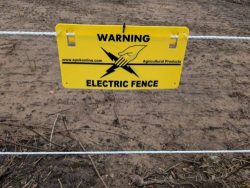
Residents have noticed changes on Isherwood Rd (on the left as you drive in from the A6144). A large vehicle was observed removing hedgerow recently. The site was left with ground disturbed and an electric fence installed.
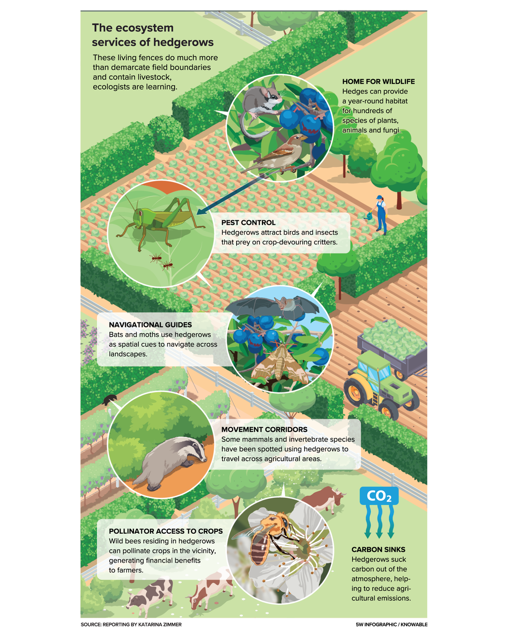
Many hedgerows are considered to be protected priority habitat. They are vital for a wide range of species, including birds, insects, and mammals, and provide essential movement and feeding corridors for wildlife. Because of their high ecological value, the conservation, restoration, and enhancement of hedgerows are typically a material consideration in planning decisions. Yet, if there is no planning application, there is no protection and no consideration of the Hedgerows Regulations 1997. Hedges and trees also protect the land from soil erosion and flooding, particularly in areas that are subject to significant surface water flooding, like Carrington Moss.
Sadly, this hedgerow destruction is not the only example. The temporary road to the planned Battery Storage System (BESS) will also damage the natural environment. That environmental damage will be carried out under ‘permitted development’ rules. This is development which requires no planning permission, there is much less oversight and NO environmental assessment! So, huge harm to the deep peat in the area, perhaps impacting the wider mossland, no protection for wildlife and birds or the habitats they use for breeding and feeding. The BESS itself will be adjacent to a Grade A site of biological importance, and the developer identified 79 bird species that will be impacted by their scheme.
Elsewhere on the moss, despite alternatives that would reduce car use to their site, MUFC has created an overspill car park on productive Grade 2 agricultural land, without any planning permission, again impacting wildlife corridors and the land used by red listed ground nesting birds, such as the skylark.
In addition, numerous large established trees were felled at the back of the National Grid site, leading to the forestry Commission posting notices forbidding any further tree felling activity without permission.
Nearby, the copse at the junction of Carrington Lane and the Spur Road has been stripped of its trees and shrubs, degrading the land before any potential planning application is submitted. The remnants of this vital former bird and wildlife corridor can be seen opposite the Mersey Farm pub
So, biodiversity can be seriously harmed without a planning application being put forward and this is all happening in addition to the destruction of the natural environment that will be caused by the proposed developments on and around Carrington Moss, including the Carrington Relief Road.
It cannot be sustainable to further deplete the populations of threatened or endangered species. And it is not only the birds and wildlife that suffer, without those trees and hedgerows, where do you think all that water will go??? Your homes and gardens, your health and wellbeing could be seriously impacted – so continue to share your photographs of all the damage being caused on and around Carrington Moss and let your councillors know what YOU think.
What is it? What are the key issues? and Why is it important for residents to respond?
As you know, the proposed developments on and around Carrington Moss are huge! 5,000 houses, 350,000m2 employment space and 4 major new roads, all threatening the 335 hectare peat moss (restorable irreplaceable habitat), the productive Grade 2 agricultural land, the woodlands and the wetlands, and all impacting 15 sites of biological importance and a site of special scientific interest, to say nothing of the populations of numerous red listed birds and endangered wildlife species.
Because of the size and scale of the proposed schemes, in addition to the typical costs that would be incurred when they put forward a planning application, developers will be required to contribute to the strategic requirements (such as roads, buildings to support education and healthcare, and utilities), which Trafford describes as ‘hard’ infrastructure. These costs would not have been required had the development been focused on previously developed (brownfield) land, rather than on former Green Belt and greenfield land in an isolated, unsustainable location.
The consultation documentation aims to set out the proportionate financial contributions for schemes that have not yet secured planning permission.
The strategy focuses on those so called ‘hard’ infrastructure items and supposedly prioritises the delivery of New Carrington “in a comprehensive and coordinated manner”. The document confirms (figure 19) that almost half of the identified ‘hard’ infrastructure costs will be funded from developer contributions, and the other half will be funded by the public sector and other sources.
Balanced? Sadly not!
Developer contributions are limited by government guidance. This means that, for a scheme to be considered viable, developers must achieve a certain level of profit. The contributions developers pay cannot be increased to the extent that the scheme would be considered unviable (ie they do not make the necessary level of profit). So, if there are any excluded or missing costs not incorporated within the calculations (and there are a lot of them), the proportions shown in the graphic above are very misleading.
The total contributions to be paid by the public sector should be explicitly and transparently shown, rather than covertly hidden in an appendix or not included at all! It is vital that communities understand the full cost of destroying our essential natural resources to facilitate building in such an unsustainable location.
The biggest issue is the lack of consideration of harms to, or destruction of, natural capital assets.
Given the extensive environmental and ecological harm/destruction to be caused as a consequence of Trafford choosing this location for development, the calculations should include the costs related to the mitigation of, or compensation for, the loss of Green Belt, the cumulative harm to natural capital assets (such as, for example, the peat moss, the woodlands, and the farmland). These have been explicitly excluded from the costs and subordinated to a future phase of the masterplanning work.
This means that the information provided in the documentation is incomplete and does not reflect the actual costs to be incurred if all the proposed developments go ahead.
Effectively, in omitting what we are calling the ‘Natural Infrastructure’ strategy from these calculations, the harms can be caused but funding may NEVER be available to provide the obligatory mitigation and compensation.
Why are we concerned?
Take a look at our response (here), but, in summary, not only have the natural infrastructure requirements been shelved to some point in the future, but our suggested amendments to the proposals have been summarily dismissed, resulting in unnecessarily inflated costs for the public purse.
The cost of the road schemes, for example, would be significantly reduced if our alternative proposals were accepted.
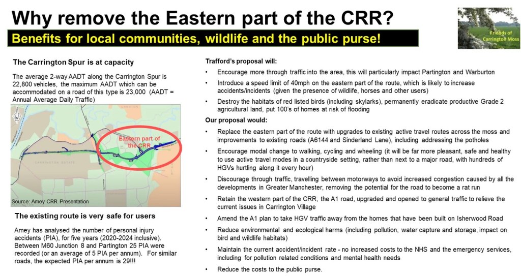
The eastern part of the Carrington Relief Road (CRR), across the moss, could be replaced with upgrades to existing active travel routes and improvements to existing roads (A6144 and Sinderland Lane). This would encourage modal change to walking, cycling and wheeling (it will be far more pleasant, safe and healthy to use active travel modes in a countryside setting, rather than next to a major road, with hundreds of HGVs hurtling along it every hour). It would also discourage the huge levels of induced traffic that will use this road, travelling between motorways and significantly impacting Partington and Warburton. The western part of the CRR, the A1 road, should be upgraded and opened to general traffic as planned to relieve the current issues in Carrington Village. The plan for the A1 should be amended to take HGV traffic away from the homes that have been built on Isherwood Road. This would require a very short road to run in parallel with Isherwood Road/Ackers Lane, rather than a new road all the way to the Carrington Spur.
The latest information received from the CRR team[1] shows that the current road (A6144) is much safer than an average road of the same type and that there is ZERO capacity to increase traffic on the Carrington Spur. Trafford should, therefore, not be proposing a new road that will allow traffic to travel at much higher speeds (particularly given the hazardous materials carried by some of the HGVs), or encourage more through traffic into the area.
Because it includes the eastern part of the road, the current CRR proposal unnecessarily inflates the cost of construction and ongoing maintenance (including for the attenuation ponds needed to capture all that water[2] currently stored on the moss), and the costs of the mitigation needed to address air, noise, light, vibration, dust and water pollution, along with other environmental enhancements. Costs will also increase for the NHS and other emergency services because of increased pollution and traffic accidents/incidents, and there is likely to be an upsurge in the requirement for mental health services due to the stresses caused to local residents because of construction, congestion, the loss of green spaces, and, possibly, future flooding!
Facilitating vehicle access onto Firsway from the new Sale West developments (1,500 homes) will significantly increase traffic and will result in that road becoming a rat run from the M60. It will require the felling of hundreds of trees, drastically affecting the wildlife and birds and impacting the dark skies in this area. It will also increase safety concerns on Firsway and, consequentially, the costs to the NHS/emergency services of dealing with any resulting pollution related health conditions and accidents/incidents on the road network. Limiting access through the Firs Plantation to active travel users only, would not only reduce the costs of constructing the Sale West Link Road, it would also reduce the cost of mitigating or compensating for environmental/ecological harms and the costs to the NHS.
For all the same reasons, we suggested that the Eastern and Southern Link Roads should not connect with each other, as this will result in huge levels of increased through traffic from the M60 and other motorways, particularly impacting Warburton. The proposed approach will also cause extensive damage to the very deep peat that will need to be compensated for. As with the other schemes, it will also significantly increase pollution and will impact the dark skies in this area, with consequential costs for the NHS and other agencies.
All the current proposals for these roads result in the need for higher contributions from the public purse, whilst our alternative options reduce the cost of constructing, the cost of mitigation/compensation for environmental/ ecological harms and the consequential costs to the healthcare sector and the emergency services.
The Healthcare costs included in the calculations seems to be limited to primary healthcare (which comprises doctors, dentists, pharmacists, and opticians), not mental health provision, not hospital provision (known as secondary healthcare) and not other emergency service provision. All of which will significantly increase as a result of the proposed developments. Furthermore, the Council does not recognise the impact on the need for increased social infrastructure because of the employment development (our objection to this is explained in our response).
Sustainable Development
The documentation repeatedly suggests that the ‘hard’ infrastructure is of the utmost importance to the sustainable delivery of New Carrington. Yet, given the definition of sustainable development this is hugely misleading.
The government’s National Planning Policy Framework (known as the NPPF[3]) defines sustainable development as “meeting the needs of the present without compromising the ability of future generations to meet their own needs”.
Given the proposed harms to, or destruction of, irreplaceable habitat, food producing cropland, woodland and wetland, it seems ‘sustainable development’ has a much narrower definition in this suite of documents.
With that definition in mind, it is clear that the New Carrington allocation cannot be ‘sustainable’, even with the proposed ‘hard’ infrastructure investment, because development here is dependent on considerable harm to, or the complete loss of, a number of essential natural capital assets that future generations will not be able to reverse.
And, what is worse, as mentioned above, the costs of mitigating and/or compensating for those cumulative harms is not even included in the calculations set out in this consultation and no information has been provided about how such funding requirements will be addressed, or when!
We would encourage you all to respond to the consultation. You do not have to go into the detail we have in our response, but it is important that the community voice is heard, particularly given that there will be future consultations related to the masterplan. Send your feedback to newcarrington.masterplan@trafford.gov.uk
What should you be asking for (in your own words)?
The masterplan project priorities should be reviewed to ensure that there is a comprehensive understanding of the costs of all elements of these proposals. The Natural Infrastructure Strategy should be considered a prerequisite to finalising the contributions scheme. It should be progressed with urgency, with its evolution including extensive engagement with communities. The land to be used for environmental and ecological mitigation or compensation should also be identified as a matter of urgency.
The documentation provided in this consultation should be updated and implemented when the full costs of the impact of development are known.
No environmental or ecological harms/destruction should be allowed to be caused until it is confirmed that funding for the mitigation and compensation for the loss of Green Belt and those extensive cumulative harms to the environment and ecology will become available. We also need confirmation of where any agreed mitigation or compensation will be located – it is possible that, because of the size and scale of the developments proposed here, enhancements will be implemented elsewhere, which means our local communities suffer all the health, wellbeing and traffic consequences of these plans, and others will benefit from environmental and ecological improvements in their areas!
As the first Carrington Relief Road (CRR) consultation goes live today (20th January 2025), we are issuing our first Call for Action to local communities. Please take the time to respond and encourage friends and family to participate too.
The consultation period includes some face-to-face sessions, and we hope you will be able to attend one of these. Just a reminder that the current CRR team are NOT responsible for the decisions made in the past and that they have been directed to give a very limited scope to the consultation, which is only based on the design of the road!
The inadequacies of this consultation have been determined by Trafford Council, and they have repeatedly rejected our requests for communities to be able to influence the wider aspects of transport solutions for the area – our next Call for Action will address this failure (see below).
This consultation ends on 28th February. Your inputs are extremely important, so do click on this link to read Trafford’s materials and submit your own response. We will be discussing this consultation at our next online public meeting on 28th January (6pm),the link to the meeting is hereand all are very welcome to join us.
At the meeting, we will highlight some of the key points to consider, which include the following:
there are two parts to the Carrington Relief Road (CRR):
we are totally supportive of the upgrading of the A1 route in Carrington (this runs through the employment zone from Isherwood Road to the A6144 near Saica Paper), all HGVs should be encouraged to use this road, rather than the A6144 through Carrington Village – this could have come forward years ago without any objections!
we are totally against the development of the road across Carrington Moss and have been proposing our alternative to Trafford for the last 4 years, without success – they are only interested in promoting the CRR, despite its escalating costs – it is a commitment to support development – not a solution aimed at benefiting existing communities
how the current design ‘benefits’ communities:
Carrington residents will only benefit from this new road if through-traffic and HGVs are unable to use the A6144 through the village, with appropriate traffic calming mechanisms put in place (otherwise, residents here will just be surrounded by constant traffic and the associated pollutant impacts)
Partington and Warburton residents will, sadly, not benefit from the scheme – Trafford has acknowledged that the road will induce additional traffic, much of which is likely to continue through Partington and Warburton, seeking an alternative route to the motorways, furthermore, given the low levels of car ownership in Partington, a new road will not reduce the isolation of this community (unlike a tram/train connection)
Sale West residents will be the most negatively affected by the scheme, they will suffer from huge increases to air, noise, light, vibration and water pollution, a significant, intensified and more frequent risk of local flooding, and the loss of the current safe, healthy and pleasant traffic-free recreational routes – we recognise that the recorded and unrecorded public rights of way will still be there, but, with the road solution, residents will be walking, cycling and horse riding next to the over 40,000 motor vehicles expected to use the road each day (including over 3,000 HGVs) – the number of vehicles will significantly increase from the current traffic numbers due to the proposed developments in the area and the induced traffic using the road as a ‘rat-run’!
Urmston residents will not benefit from the scheme either, but they are also likely to see an increase in traffic on their local roads and the risk of local flooding will increase due to the loss of water capture and storage on Carrington Moss (we do not believe the proposed attenuation ponds will be sufficient to replace the capacity lost when the road is built)
how the design ‘mitigates and compensates for the impact on the natural environment’:
the part of the road that cuts across Carrington Moss will severely impact red listed birds (including, for example, the skylark, which is prevalent along the route of the road) and protected/endangered species – we are very saddened by the thought of yet more roadkill!
the road will fracture the corridors used by wildlife and birds to access food and water sources – this will result in further depletion of their species
the road will also damage the peat moss (a restorable 335-hectare irreplaceable habitat according to Natural England) and the sites of biological importance/site of special scientific interest, even where these are not directly impacted – this is because of the changes to hydrology that will be required to keep the road water-free
it is likely that Trafford will consider that the attenuation ponds will replace the immense water capture and storage functionality of the moss – we think they underestimate the level of water captured here and this could lead to huge risks for local communities
Trafford is also likely to assume that these pond areas will create biodiversity gains, but what must be considered is that the losses will be experienced immediately, whereas any gains could take years to deliver, and, in that time, species will be lost to the area forever
the road will also impact the potential opportunities to support the Local Nature Recovery Strategy
the loss of productive Grade 2 agricultural land will impact future food security as this cannot be replaced elsewhere in Trafford
how the design constrains the development of the New Carrington Masterplan which is currently under development and covers the whole allocation area:
the CRR will significantly restrict and constrain what is possible in terms of recreational, ecological and natural capital benefits for the Sale West area, considerably increasing the inequities of access to green space for residents
the Natural Infrastructure Strategy underpinning the Masterplan has not yet even been discussed – this should determine the approach to mitigation and compensation for environmental and ecological harms to be caused across the allocation area (including the cumulative harms) – such issues should not be addressed as piecemeal solutions for individual developments, including the CRR.
Whilst we are keen for residents to respond as constructively as possible to this consultation, we also need to recognise that Trafford has not given communities the opportunity to influence either:
the choice of transport options for this area (why weren’t we asked if we wanted trams or trains, given the size and scale of the developments they are proposing, the number of years this has been under consideration, and the sheer common sense that we should make full use of the former railway lines running through the allocation area and the proximity of the Manchester Ship Canal?), or
the route options for the road.
You might want to mention this in the final section of the response questionnaire (headed “Further Comments / Queries), but with these things in mind, there will be a future Call for Action from local communities to address the total lack of previous consultation about the CRR.
Look out for our next blog for more community action on the Carrington Relief Road Consultation.
Houses on stilts? An estate by the lake? HGVs replaced by boats (well we like that idea)!
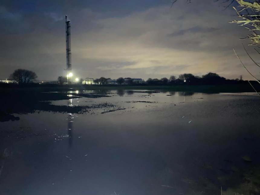
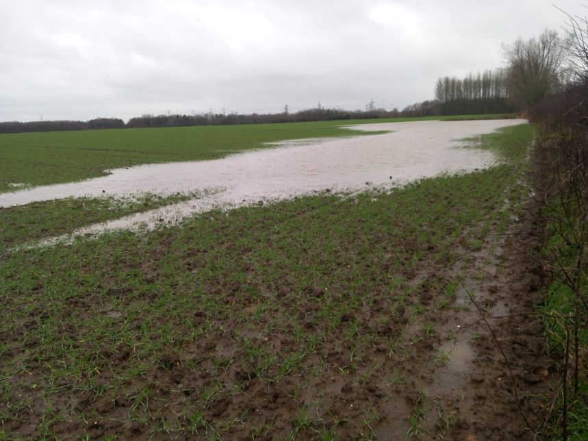
The recent heavy rainfall event significantly impacted many in our communities (and beyond), not only causing disruption to travel and a lot of inconvenience (wonder who’ll be jailed for that*) but also, very sadly, causing the deaths of wildlife and domestic animals. The Manchester Evening News (2nd January) reported that 1,000 people were evacuated from their homes and several major roads were under water and closed for a long period.
Whilst Trafford was “working closely with the Environment Agency, fire and rescue services, and the police to provide support to those in urgent need”, there was a huge amount of community support too. Thanks to everyone who did their bit, particular thanks to Carrington Riding Centre for their support to those affected (humans and animals).
Despite the Environment Agency issuing six flood warning and four flood alerts, the Mayor of Greater Manchester, Andy Burnham, astoundingly stated that the severity of the flooding took authorities by surprise because no specific warnings were given! He has called for “accountability”. We wonder what he actually means by that.
Will he and his colleagues, the leaders of 9 districts in Greater Manchester, be held accountable, for example, for their decision to allocate land that is essential for climate mitigation in his Places for Everyone Spatial Plan. One of those allocations is New Carrington, in which Trafford Council proposes to approve the development of 5,000 houses, 350,000m2 warehousing and 4 major new roads!
These developments will mean that huge swathes of land that is currently capturing and storing thousands of litres of water will be concreted over, against the wishes of local communities, causing significant environmental and ecological harm and causing enormous risks to future generations (and not just in relation to flooding).
There is a lack of understanding at Trafford Council about just how much water is hosted by Carrington Moss. This area has saved local communities from more severe flooding for decades. You can see some of our videos showing the extent of flooding in previous years on the Carrington Lake page of our website.
The Met Office (and many others) have reported that rainfall is now heavier and more frequent than in the past. Their scientists found that “rainfall associated with storms is becoming both more intense and more likely”. Whereas we could, at one time, expect such events to be once in 50 years or so, those extreme weather conditions are now expected to occur at least once every five years.
This means that wetland habitats, like Carrington Moss, are hugely valuable for the ecosystem services they provide.
What is really worrying many in existing communities though, is that, if this very wet land is developed, future heavy rainfall events will not have the benefit of Carrington Moss to protect local areas. Once a flood event has happened to their homes, residents will find it difficult to get insurance and there will be huge costs to the public sector (which is funded by us).
Much of the land that is proposed for development is under high levels of water. The Council and developers will tell residents that they have a sustainable drainage strategy but let’s be clear, draining all this water into the River Mersey (or Sinderland Brook) will cause local and downstream flooding. This is contrary to national guidance and our concerns about this issue have been repeatedly ignored by Trafford, the Greater Manchester Combined Authority and the PfE Planning Inspectors.
Will they all be held accountable for future flood events that occur here and in surrounding communities?
Many of you will have seen the Manchester Evening News article that reported the closure (once again) of the A555 Airport Relief Road, which had cars submerged to their rooftops! Transport solutions such as this do not benefit anyone, and as Trafford themselves admit, the new road here (Carrington Relief Road) is expected to induce additional traffic into the area (definitely not what we need).
We are currently expecting the consultation for the Carrington Relief Road to be issued later this month. Please keep this flooding in mind when you respond. We believe our alternative option is a more sustainable solution that will benefit both current and future residents.
For more information about our ongoing campaign, please sign up to our monthly newsletter here and join us at our monthly online public meetings.
Note: Image credits Rob Duncan, Mary Lennon and Tony Shearwood
*for anyone who does not understand this reference, protestors who cause inconvenience to others by, for example, sitting in the road to raise an issue, can be jailed – yet those who knowingly make decisions that result in far more serious implications, such as planning for or approving development in areas that should be capturing flood water, putting current and future communities at real risk of harm, currently escape any accountability or punishment!


You must be logged in to post a comment.